Property Record
2815 Dixie Hwy, Dry Ridge, KY 41035

NEARBY LISTINGS FOR SALE OR LEASE
-
-
View all Dry Ridge listings for lease on LoopNet.com
Property Detail
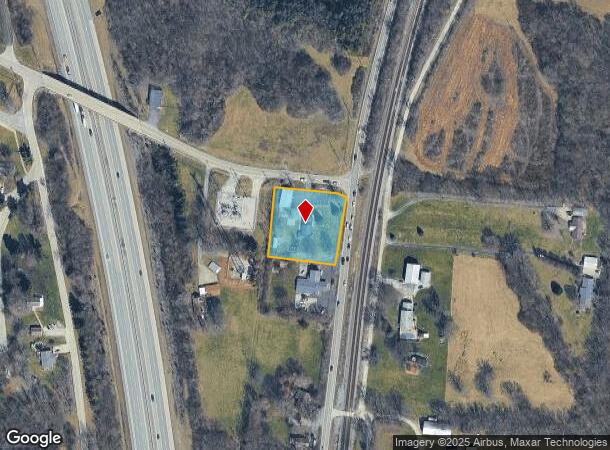
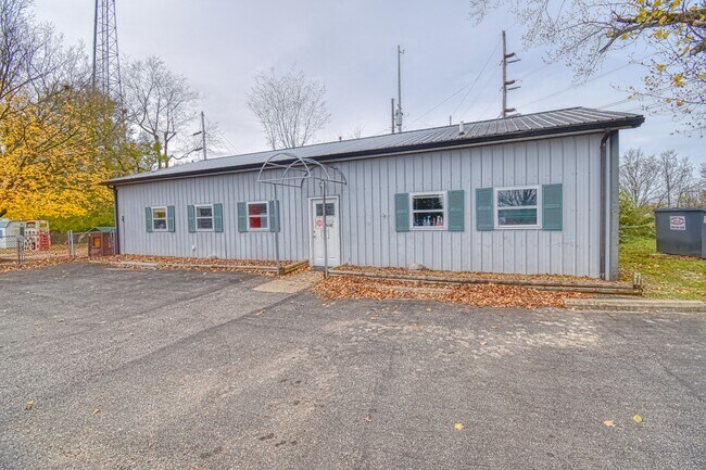
2815 Dixie Hwy
043-00-00-002.00
CHILD CARE CENTER & 1.06 AC
Privateschool
Grant
X
Kentucky
21015C0325D
1.06 AC
2025
Grant County
2025
Cincinnati/Dayton
920102
Cincinnati, OH-KY-IN
1,914 SF
DEMOGRAPHICS near 2815 Dixie Hwy
1 Mile
3 Mile
5 Mile
2024 Total Population
1,408
5,909
14,348
2029 Population
1,514
6,296
15,147
Pop Growth 2024-2029
+ 7.53%
+ 6.55%
+ 5.57%
Average Age
34
36
37
2024 Total Households
469
1,998
5,135
HH Growth 2024-2029
+ 7.68%
+ 6.56%
+ 5.59%
Median Household Inc
$68,707
$74,499
$61,700
Avg Household Size
3.00
2.90
2.80
2024 Avg HH Vehicles
2.00
2.00
2.00
Median Home Value
$151,479
$160,323
$180,699
Median Year Built
1992
1995
1992
Nearby Places
Map Layers
Map Styles
 Street
 Aerial
- Restaurants
- Banks
- Shops
- Fitness
- Groceries
PUBLIC TRANSPORTATION
AIRPORT
Cincinnati/Northern Kentucky International
DRIVE
WALK
Distance
Cincinnati/Northern Kentucky International
33 min
22.1 mi
Freight Ports
Port of Toledo
DRIVE
WALK
Distance
Port of Toledo
275 min
234.1 mi
SALE & LEASE HISTORY
LISTING DATE
SALE/LEASE

Nov 08, 2020
For Sale
May 12, 2020
For Sale
Jan 07, 2021
For Lease
Nearby Properties
Address
Land Use
TOTAL SIZE
Lot Size
Zoning
Address
Land Use
TOTAL SIZE
Lot Size
Zoning
3.88 AC
Address
Land Use
TOTAL SIZE
Lot Size
Zoning
2,032 SF
28.30 AC
Address
Land Use
TOTAL SIZE
Lot Size
Zoning
4,736 SF
0.50 AC
Address
Land Use
TOTAL SIZE
Lot Size
Zoning
39,000 SF
5.97 AC
Address
Land Use
TOTAL SIZE
Lot Size
Zoning
1,680 SF
65.43 AC
Address
Land Use
TOTAL SIZE
Lot Size
Zoning
66.39 AC
Address
Land Use
TOTAL SIZE
Lot Size
Zoning
20,000 SF
5 AC
Address
Land Use
TOTAL SIZE
Lot Size
Zoning
114.02 AC
Address
Land Use
TOTAL SIZE
Lot Size
Zoning
5,760 SF
0.76 AC
Address
Land Use
TOTAL SIZE
Lot Size
Zoning
33.67 AC
Address
Land Use
TOTAL SIZE
Lot Size
Zoning
3,488 SF
6.42 AC
Address
Land Use
TOTAL SIZE
Lot Size
Zoning
11,787 SF
2.33 AC
Address
Land Use
TOTAL SIZE
Lot Size
Zoning
13.50 AC
Address
Land Use
TOTAL SIZE
Lot Size
Zoning
1,680 SF
44.58 AC
Address
Land Use
TOTAL SIZE
Lot Size
Zoning
14,912 SF
3 AC
Address
Land Use
TOTAL SIZE
Lot Size
Zoning
1.94 AC
Address
Land Use
TOTAL SIZE
Lot Size
Zoning
14,000 SF
2.19 AC
Address
Land Use
TOTAL SIZE
Lot Size
Zoning
2,304 SF
217.90 AC
Address
Land Use
TOTAL SIZE
Lot Size
Zoning
8,064 SF
2.20 AC
Address
Land Use
TOTAL SIZE
Lot Size
Zoning
1,728 SF
12.16 AC
Address
Land Use
TOTAL SIZE
Lot Size
Zoning
6.40 AC
Address
Land Use
TOTAL SIZE
Lot Size
Zoning
0.95 AC
Address
Land Use
TOTAL SIZE
Lot Size
Zoning
20,000 SF
39.26 AC
Address
Land Use
TOTAL SIZE
Lot Size
Zoning
5,218 SF
1.15 AC
Address
Land Use
TOTAL SIZE
Lot Size
Zoning
1.63 AC
Address
Land Use
TOTAL SIZE
Lot Size
Zoning
4,048 SF
1.07 AC
Address
Land Use
TOTAL SIZE
Lot Size
Zoning
23.81 AC
Address
Land Use
TOTAL SIZE
Lot Size
Zoning
9,448 SF
2.59 AC
Address
Land Use
TOTAL SIZE
Lot Size
Zoning
21.99 AC
Address
Land Use
TOTAL SIZE
Lot Size
Zoning
2.19 AC
The World's #1 Commercial Real Estate Marketplace
Connect with us
© 2026 CoStar Group
The information above has been obtained from sources believed reliable. While we do not doubt its accuracy we have not verified it and make no guarantee, warranty or representation about it. It is your responsibility to independently confirm its accuracy and completeness. Any projections, opinions, assumptions, or estimates used are for example only and do not represent the current or future performance of the property. The value of this transaction to you depends on tax and other factors which should be evaluated by your tax, financial, and legal advisors. You and your advisors should conduct a careful, independent investigation of the property to determine to your satisfaction the suitability of the property for your needs.