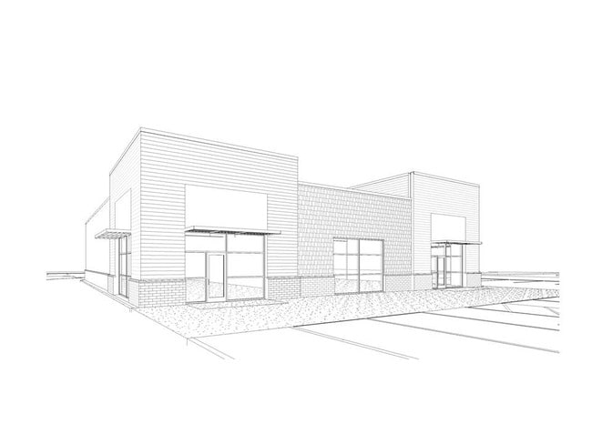
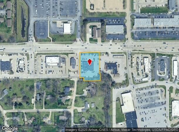
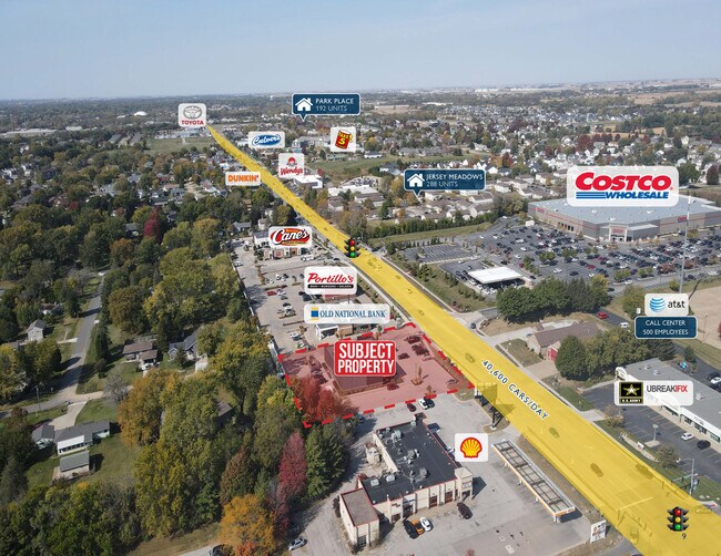
Property Record
2815 E 53Rd St, Davenport, IA 52807
NEARBY LISTINGS FOR SALE OR LEASE
Property Detail
2815 E 53Rd St
N0712A05
Hanlins Crossing
Stripcommercialcenter
HANLIN'S CROSSING LOT: 5
X
Scott
19163C0360H
Iowa
2025
1.25 AC
2025
Greater Davenport
012902
Davenport/Moline/Rock Island
7,796 SF
Davenport-Moline-Rock Island, IA-IL
DEMOGRAPHICS near 2815 E 53Rd St
1 Mile
3 Mile
5 Mile
2024 Total Population
5,888
57,375
129,700
2029 Population
5,836
57,110
129,222
Pop Growth 2024-2029
(0.88%)
(0.46%)
(0.37%)
Average Age
42
40
39
2024 Total Households
2,607
24,232
53,859
HH Growth 2024-2029
(0.96%)
(0.57%)
(0.39%)
Median Household Inc
$72,209
$76,778
$62,583
Avg Household Size
2.20
2.30
2.30
2024 Avg HH Vehicles
2.00
2.00
2.00
Median Home Value
$303,462
$208,167
$186,877
Median Year Built
1996
1975
1970
Nearby Places
Map Layers
Map Styles
 Street
 Aerial
- Restaurants
- Banks
- Shops
- Fitness
- Groceries
PUBLIC TRANSPORTATION
AIRPORT
Quad Cities International
DRIVE
WALK
Distance
Quad Cities International
30 min
15.3 mi
SALE & LEASE HISTORY
LISTING DATE
SALE/LEASE

Nov 04, 2024
For Sale
Jun 25, 2019
For Lease
Nearby Properties
Address
Land Use
TOTAL SIZE
Lot Size
Zoning
Address
Land Use
TOTAL SIZE
Lot Size
Zoning
7,934 SF
8.41 AC
Address
Land Use
TOTAL SIZE
Lot Size
Zoning
157,587 SF
33.92 AC
Address
Land Use
TOTAL SIZE
Lot Size
Zoning
92,431 SF
40.01 AC
Address
Land Use
TOTAL SIZE
Lot Size
Zoning
2,045 SF
29.48 AC
Address
Land Use
TOTAL SIZE
Lot Size
Zoning
128,100 SF
14.65 AC
Address
Land Use
TOTAL SIZE
Lot Size
Zoning
45,602 SF
149.61 AC
Address
Land Use
TOTAL SIZE
Lot Size
Zoning
27,225 SF
40.34 AC
Address
Land Use
TOTAL SIZE
Lot Size
Zoning
27,306 SF
50.57 AC
Address
Land Use
TOTAL SIZE
Lot Size
Zoning
4,518 SF
6.27 AC
Address
Land Use
TOTAL SIZE
Lot Size
Zoning
50,882 SF
5.10 AC
Address
Land Use
TOTAL SIZE
Lot Size
Zoning
472,569 SF
47.24 AC
Address
Land Use
TOTAL SIZE
Lot Size
Zoning
123,823 SF
6.46 AC
Address
Land Use
TOTAL SIZE
Lot Size
Zoning
1,800 SF
60.86 AC
Address
Land Use
TOTAL SIZE
Lot Size
Zoning
133,809 SF
8.26 AC
Address
Land Use
TOTAL SIZE
Lot Size
Zoning
4,944 SF
17.91 AC
Address
Land Use
TOTAL SIZE
Lot Size
Zoning
25,176 SF
13.85 AC
Address
Land Use
TOTAL SIZE
Lot Size
Zoning
26,472 SF
17.67 AC
Address
Land Use
TOTAL SIZE
Lot Size
Zoning
27,312 SF
15.04 AC
Address
Land Use
TOTAL SIZE
Lot Size
Zoning
8,000 SF
4.59 AC
Address
Land Use
TOTAL SIZE
Lot Size
Zoning
111,979 SF
6.86 AC
Address
Land Use
TOTAL SIZE
Lot Size
Zoning
156,632 SF
17.67 AC
Address
Land Use
TOTAL SIZE
Lot Size
Zoning
71,820 SF
5.71 AC
Address
Land Use
TOTAL SIZE
Lot Size
Zoning
197,946 SF
18.64 AC
Address
Land Use
TOTAL SIZE
Lot Size
Zoning
3,543 SF
14.79 AC
Address
Land Use
TOTAL SIZE
Lot Size
Zoning
4,800 SF
18.86 AC
Address
Land Use
TOTAL SIZE
Lot Size
Zoning
84,002 SF
21.76 AC
Address
Land Use
TOTAL SIZE
Lot Size
Zoning
4,958 SF
15.49 AC
Address
Land Use
TOTAL SIZE
Lot Size
Zoning
115,968 SF
2.93 AC
Address
Land Use
TOTAL SIZE
Lot Size
Zoning
226,764 SF
23.52 AC
Address
Land Use
TOTAL SIZE
Lot Size
Zoning
50,880 SF
11.36 AC
The World's #1 Commercial Real Estate Marketplace
Connect with us
© 2025 CoStar Group
The information above has been obtained from sources believed reliable. While we do not doubt its accuracy we have not verified it and make no guarantee, warranty or representation about it. It is your responsibility to independently confirm its accuracy and completeness. Any projections, opinions, assumptions, or estimates used are for example only and do not represent the current or future performance of the property. The value of this transaction to you depends on tax and other factors which should be evaluated by your tax, financial, and legal advisors. You and your advisors should conduct a careful, independent investigation of the property to determine to your satisfaction the suitability of the property for your needs.