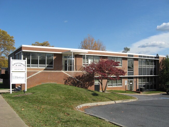
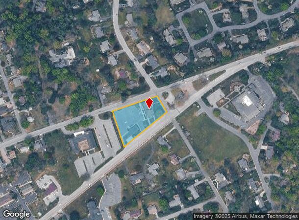
Property Record
2815 N Augusta St, Staunton, VA 24401

NEARBY LISTINGS FOR SALE OR LEASE
Property Detail
2815 N Augusta St
Staunton-Waynesboro, VA
Belmont Terrace
5544
SEC 4 LOTS 4-6 & PORTIONS LOTS 7-9 & 13-16
Officebuilding
Staunton City
X
Virginia
51015C0341D
4-9
2025
0.78 AC
2025
Staunton & Harrisonburg
000500
Other Market Areas
5,000 SF
DEMOGRAPHICS near 2815 N Augusta St
1 Mile
3 Mile
5 Mile
2024 Total Population
3,069
26,206
38,631
2029 Population
3,146
26,836
39,529
Pop Growth 2024-2029
+ 2.51%
+ 2.40%
+ 2.32%
Average Age
47
42
43
2024 Total Households
1,281
11,256
16,415
HH Growth 2024-2029
+ 2.58%
+ 2.53%
+ 2.43%
Median Household Inc
$90,145
$56,787
$55,884
Avg Household Size
2.20
2.10
2.20
2024 Avg HH Vehicles
2.00
2.00
2.00
Median Home Value
$284,931
$213,506
$219,675
Median Year Built
1964
1964
1970
Nearby Places
Map Layers
Map Styles
 Street
 Aerial
- Restaurants
- Banks
- Shops
- Fitness
- Groceries
PUBLIC TRANSPORTATION
COMMUTER RAIL
Staunton Amtrak Station (Cardinal - Amtrak)
DRIVE
WALK
Distance
Staunton Amtrak Station (Cardinal - Amtrak)
4 min
2.3 mi
Freight Ports
Virginia Port Authority - Richmond
DRIVE
WALK
Distance
Virginia Port Authority - Richmond
136 min
117.3 mi
SALE & LEASE HISTORY
LISTING DATE
SALE/LEASE

Dec 10, 2021
For Lease
Nearby Properties
Address
Land Use
TOTAL SIZE
Lot Size
Zoning
Address
Land Use
TOTAL SIZE
Lot Size
Zoning
360,085 SF
66.35 AC
I-1
Address
Land Use
TOTAL SIZE
Lot Size
Zoning
262,369 SF
24.50 AC
GENERAL BU
Address
Land Use
TOTAL SIZE
Lot Size
Zoning
43,097 SF
72.85 AC
R3
Address
Land Use
TOTAL SIZE
Lot Size
Zoning
12,720 SF
13.10 AC
HE
Address
Land Use
TOTAL SIZE
Lot Size
Zoning
132,832 SF
50.44 AC
GENERAL BU
Address
Land Use
TOTAL SIZE
Lot Size
Zoning
218,331 SF
40 AC
PLANNED CO
Address
Land Use
TOTAL SIZE
Lot Size
Zoning
103,781 SF
32.37 AC
R3
Address
Land Use
TOTAL SIZE
Lot Size
Zoning
700,000 SF
46.55 AC
I2
Address
Land Use
TOTAL SIZE
Lot Size
Zoning
515,766 SF
81.76 AC
GENERAL IN
Address
Land Use
TOTAL SIZE
Lot Size
Zoning
20,304 SF
6.67 AC
R4
Address
Land Use
TOTAL SIZE
Lot Size
Zoning
32,976 SF
6.20 AC
R4
Address
Land Use
TOTAL SIZE
Lot Size
Zoning
202,650 SF
33.59 AC
B2
Address
Land Use
TOTAL SIZE
Lot Size
Zoning
72,933 SF
8.71 AC
B2
Address
Land Use
TOTAL SIZE
Lot Size
Zoning
18,750 SF
16.51 AC
HE
Address
Land Use
TOTAL SIZE
Lot Size
Zoning
101,384 SF
11.77 AC
R3
Address
Land Use
TOTAL SIZE
Lot Size
Zoning
222,668 SF
34.23 AC
I2
Address
Land Use
TOTAL SIZE
Lot Size
Zoning
38,772 SF
8.58 AC
GENERAL BU
Address
Land Use
TOTAL SIZE
Lot Size
Zoning
158,300 SF
30 AC
R2
Address
Land Use
TOTAL SIZE
Lot Size
Zoning
66,309 SF
12.09 AC
B2
Address
Land Use
TOTAL SIZE
Lot Size
Zoning
61,798 SF
8.52 AC
R2
Address
Land Use
TOTAL SIZE
Lot Size
Zoning
100,501 SF
0.32 AC
B2
Address
Land Use
TOTAL SIZE
Lot Size
Zoning
54,507 SF
2.69 AC
B2
Address
Land Use
TOTAL SIZE
Lot Size
Zoning
25,002 SF
10.04 AC
R3
Address
Land Use
TOTAL SIZE
Lot Size
Zoning
56,600 SF
18.89 AC
B2
Address
Land Use
TOTAL SIZE
Lot Size
Zoning
48,904 SF
5.17 AC
P1
Address
Land Use
TOTAL SIZE
Lot Size
Zoning
107,455 SF
5.82 AC
P1
Address
Land Use
TOTAL SIZE
Lot Size
Zoning
121,204 SF
12.99 AC
B2
Address
Land Use
TOTAL SIZE
Lot Size
Zoning
8,640 SF
3.23 AC
R3
Address
Land Use
TOTAL SIZE
Lot Size
Zoning
111,992 SF
7.13 AC
PLANNED CO
Address
Land Use
TOTAL SIZE
Lot Size
Zoning
41,264 SF
2.70 AC
B2
The World's #1 Commercial Real Estate Marketplace
Connect with us
© 2025 CoStar Group
The information above has been obtained from sources believed reliable. While we do not doubt its accuracy we have not verified it and make no guarantee, warranty or representation about it. It is your responsibility to independently confirm its accuracy and completeness. Any projections, opinions, assumptions, or estimates used are for example only and do not represent the current or future performance of the property. The value of this transaction to you depends on tax and other factors which should be evaluated by your tax, financial, and legal advisors. You and your advisors should conduct a careful, independent investigation of the property to determine to your satisfaction the suitability of the property for your needs.