Property Record
2815 Packerland Dr, Green Bay, WI 54313

Save to a Folder
{{folder.Name}}
{{folder.ListingIds.length}} Properties
{{folder.ListingIds.length}} Property
Create a New Folder
Property Detail
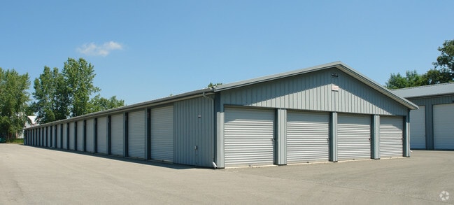
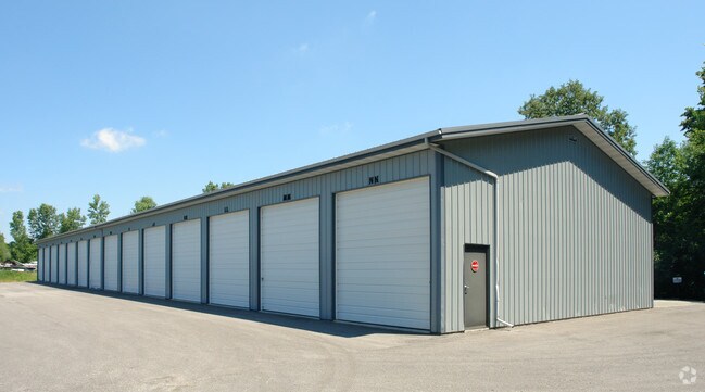
2815 Packerland Dr
Green Bay, WI
132,000 SQ FT LOT 1 OF 42 CSM 48 MAP 6310 IN 1791533 BNG PART OF LOTS 2 & 3 SEC 8 T23N R20E
HB-905
Brown
Commercialnec
Wisconsin
B and X Area of moderate flood hazard, usually the area between the limits of the 100-year and 500-year floods.
1,2,3
2025
3.03 AC
2025
Ashwaubenon
940006
Green Bay
NEARBY LISTINGS FOR SALE OR LEASE
-
-
View all Green Bay listings for sale on LoopNet.com
DEMOGRAPHICS near 2815 Packerland Dr
1 mile
3 mile
5 mile
2025 Total Population
3,698
36,487
114,580
2030 Population
3,712
37,136
116,464
Pop Growth 2025-2030
+ 0.38%
+ 1.78%
+ 1.64%
Average Age
43
42
41
2025 Total Households
1,480
15,698
48,116
HH Growth 2025-2030
+ 0.41%
+ 1.95%
+ 1.73%
Median Household Inc
$105,986
$78,979
$75,121
Avg Household Size
2.50
2.30
2.30
2025 Avg HH Vehicles
2.00
2.00
2.00
Median Home Value
$299,778
$267,805
$255,426
Median Year Built
1977
1978
1974
Nearby Places
Map Layers
Map Styles
 Street
 Aerial
Layers
 Traffic
 Biking
Places
Listings with unknown addresses are not visible on the map
- Restaurants
- Banks
- Shops
- Fitness
- Groceries
PUBLIC TRANSPORTATION
AIRPORT
Green Bay/Austin Straubel International
Drive
Walk
Distance
Green Bay/Austin Straubel International
4 min
0.9 mi
Appleton International
Drive
Walk
Distance
Appleton International
43 min
34.2 mi
Nearby Properties
Address
Land Use
TOTAL SIZE
Lot Size
Zoning
Address
Land Use
TOTAL SIZE
Lot Size
Zoning
11.89 AC
Address
Land Use
TOTAL SIZE
Lot Size
Zoning
21.87 AC
Address
Land Use
TOTAL SIZE
Lot Size
Zoning
0.62 AC
Address
Land Use
TOTAL SIZE
Lot Size
Zoning
27.86 AC
Address
Land Use
TOTAL SIZE
Lot Size
Zoning
Address
Land Use
TOTAL SIZE
Lot Size
Zoning
25.31 AC
Address
Land Use
TOTAL SIZE
Lot Size
Zoning
Address
Land Use
TOTAL SIZE
Lot Size
Zoning
71.85 AC
Address
Land Use
TOTAL SIZE
Lot Size
Zoning
45.50 AC
Address
Land Use
TOTAL SIZE
Lot Size
Zoning
18.61 AC
Address
Land Use
TOTAL SIZE
Lot Size
Zoning
3.90 AC
Address
Land Use
TOTAL SIZE
Lot Size
Zoning
17,227 SF
3.13 AC
GI
Address
Land Use
TOTAL SIZE
Lot Size
Zoning
1.99 AC
Address
Land Use
TOTAL SIZE
Lot Size
Zoning
20.83 AC
Address
Land Use
TOTAL SIZE
Lot Size
Zoning
26.42 AC
Address
Land Use
TOTAL SIZE
Lot Size
Zoning
9.14 AC
Address
Land Use
TOTAL SIZE
Lot Size
Zoning
Address
Land Use
TOTAL SIZE
Lot Size
Zoning
37.22 AC
Address
Land Use
TOTAL SIZE
Lot Size
Zoning
Address
Land Use
TOTAL SIZE
Lot Size
Zoning
Address
Land Use
TOTAL SIZE
Lot Size
Zoning
2.11 AC
Address
Land Use
TOTAL SIZE
Lot Size
Zoning
2.98 AC
Address
Land Use
TOTAL SIZE
Lot Size
Zoning
5.94 AC
Address
Land Use
TOTAL SIZE
Lot Size
Zoning
17.66 AC
Address
Land Use
TOTAL SIZE
Lot Size
Zoning
13.58 AC
Address
Land Use
TOTAL SIZE
Lot Size
Zoning
43.27 AC
Address
Land Use
TOTAL SIZE
Lot Size
Zoning
15.41 AC
Address
Land Use
TOTAL SIZE
Lot Size
Zoning
6.34 AC
Address
Land Use
TOTAL SIZE
Lot Size
Zoning
1.65 AC
Address
Land Use
TOTAL SIZE
Lot Size
Zoning
6.55 AC
The World's #1 Commercial Real Estate Marketplace
Connect with us
© 2026 CoStar Group
The information above has been obtained from sources believed reliable. While we do not doubt its accuracy we have not verified it and make no guarantee, warranty or representation about it. It is your responsibility to independently confirm its accuracy and completeness. Any projections, opinions, assumptions, or estimates used are for example only and do not represent the current or future performance of the property. The value of this transaction to you depends on tax and other factors which should be evaluated by your tax, financial, and legal advisors. You and your advisors should conduct a careful, independent investigation of the property to determine to your satisfaction the suitability of the property for your needs.