Property Record
2815 Saint Andrews Loop, Pasco, WA 99301


Save to a Folder
{{folder.Name}}
{{folder.ListingIds.length}} Properties
{{folder.ListingIds.length}} Property
Create a New Folder
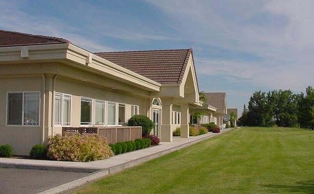
Property Detail
2815 Saint Andrews Loop
Kennewick-Richland, WA
PTN 19-9-30 DAF: BINDING SITE PLAN 98-3 LOT 2
113-300-216
Franklin
Commercialnec
Washington
0
2
2025
0.62 AC
020300
Yakima/Kennewick
10,772 SF
Other Market Areas
NEARBY LISTINGS FOR SALE OR LEASE
DEMOGRAPHICS near 2815 Saint Andrews Loop
1 mile
3 mile
5 mile
2025 Total Population
7,937
54,944
132,916
2030 Population
8,197
57,047
138,493
Pop Growth 2025-2030
+ 3.28%
+ 3.83%
+ 4.20%
Average Age
34
34
35
2025 Total Households
2,298
16,457
43,314
HH Growth 2025-2030
+ 3.44%
+ 3.95%
+ 4.29%
Median Household Inc
$56,655
$76,340
$71,439
Avg Household Size
3.20
3.20
3.00
2025 Avg HH Vehicles
2.00
2.00
2.00
Median Home Value
$259,259
$357,364
$357,030
Median Year Built
1969
1983
1980
Nearby Places
Map Layers
Map Styles
 Street
 Aerial
Layers
 Traffic
 Biking
Places
Listings with unknown addresses are not visible on the map
- Restaurants
- Banks
- Shops
- Fitness
- Groceries
PUBLIC TRANSPORTATION
COMMUTER RAIL
Drive
Walk
Distance
7 min
2.9 mi
AIRPORT
Tri-Cities
Drive
Walk
Distance
Tri-Cities
3 min
0.8 mi
SALE & LEASE HISTORY
LISTING DATE
SALE/LEASE

Oct 31, 2023
For Lease
Feb 01, 2019
For Lease
Aug 01, 2022
For Lease
Apr 06, 2017
For Lease
Nearby Properties
Address
Land Use
TOTAL SIZE
Lot Size
Zoning
Address
Land Use
TOTAL SIZE
Lot Size
Zoning
277,478 SF
27.86 AC
Address
Land Use
TOTAL SIZE
Lot Size
Zoning
53,980 SF
25.90 AC
Address
Land Use
TOTAL SIZE
Lot Size
Zoning
32.48 AC
Address
Land Use
TOTAL SIZE
Lot Size
Zoning
2,863,808 SF
28.33 AC
Address
Land Use
TOTAL SIZE
Lot Size
Zoning
375,317 SF
17.68 AC
Address
Land Use
TOTAL SIZE
Lot Size
Zoning
189,054 SF
28.48 AC
Address
Land Use
TOTAL SIZE
Lot Size
Zoning
444,084 SF
58 AC
Address
Land Use
TOTAL SIZE
Lot Size
Zoning
204,680 SF
39.50 AC
Address
Land Use
TOTAL SIZE
Lot Size
Zoning
161,465 SF
24.12 AC
Address
Land Use
TOTAL SIZE
Lot Size
Zoning
214,102 SF
9.88 AC
Address
Land Use
TOTAL SIZE
Lot Size
Zoning
163,900 SF
11.90 AC
Address
Land Use
TOTAL SIZE
Lot Size
Zoning
153,320 SF
7.37 AC
Address
Land Use
TOTAL SIZE
Lot Size
Zoning
114,673 SF
6.58 AC
Address
Land Use
TOTAL SIZE
Lot Size
Zoning
84,951 SF
4.39 AC
Address
Land Use
TOTAL SIZE
Lot Size
Zoning
64,936 SF
Address
Land Use
TOTAL SIZE
Lot Size
Zoning
84,680 SF
3 AC
Address
Land Use
TOTAL SIZE
Lot Size
Zoning
181,290 SF
33.52 AC
Address
Land Use
TOTAL SIZE
Lot Size
Zoning
67,635 SF
5.95 AC
Address
Land Use
TOTAL SIZE
Lot Size
Zoning
278,800 SF
110.64 AC
Address
Land Use
TOTAL SIZE
Lot Size
Zoning
241,912 SF
12.99 AC
Address
Land Use
TOTAL SIZE
Lot Size
Zoning
88,510 SF
14.04 AC
Address
Land Use
TOTAL SIZE
Lot Size
Zoning
20,919 SF
58.49 AC
KENNEWICK
Address
Land Use
TOTAL SIZE
Lot Size
Zoning
103,750 SF
14.97 AC
Address
Land Use
TOTAL SIZE
Lot Size
Zoning
58,701 SF
11.34 AC
Address
Land Use
TOTAL SIZE
Lot Size
Zoning
80,604 SF
4.30 AC
Address
Land Use
TOTAL SIZE
Lot Size
Zoning
75,542 SF
6.36 AC
Address
Land Use
TOTAL SIZE
Lot Size
Zoning
125,508 SF
3.49 AC
Address
Land Use
TOTAL SIZE
Lot Size
Zoning
110,458 SF
20 AC
Address
Land Use
TOTAL SIZE
Lot Size
Zoning
96,442 SF
7.46 AC
Address
Land Use
TOTAL SIZE
Lot Size
Zoning
86,712 SF
4.15 AC
The World's #1 Commercial Real Estate Marketplace
Connect with us
© 2026 CoStar Group
The information above has been obtained from sources believed reliable. While we do not doubt its accuracy we have not verified it and make no guarantee, warranty or representation about it. It is your responsibility to independently confirm its accuracy and completeness. Any projections, opinions, assumptions, or estimates used are for example only and do not represent the current or future performance of the property. The value of this transaction to you depends on tax and other factors which should be evaluated by your tax, financial, and legal advisors. You and your advisors should conduct a careful, independent investigation of the property to determine to your satisfaction the suitability of the property for your needs.