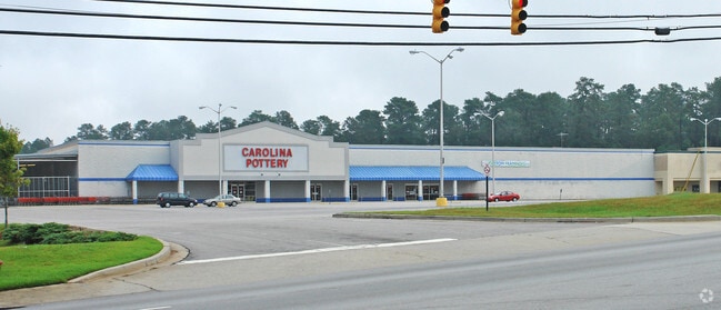
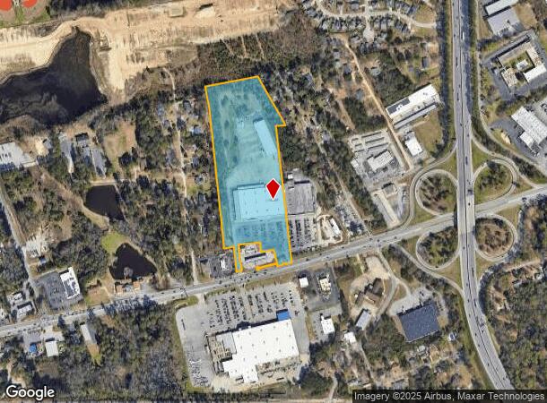
Property Record
2816 Augusta Rd, West Columbia, SC 29170


NEARBY LISTINGS FOR SALE OR LEASE
Property Detail
2816 Augusta Rd
004599-07-039
Prepared For Marsh Pottery Llc
Wholesaleoutletdiscountstore
TRACT 1
X
Lexington
45063C0276J
South Carolina
2025
13.56 AC
2024
Cayce/West Columbia
020513
Columbia
69,870 SF
Columbia, SC
DEMOGRAPHICS near 2816 Augusta Rd
1 Mile
3 Mile
5 Mile
2024 Total Population
5,141
42,524
121,099
2029 Population
5,607
46,427
129,048
Pop Growth 2024-2029
+ 9.06%
+ 9.18%
+ 6.56%
Average Age
40
41
37
2024 Total Households
2,133
18,964
52,197
HH Growth 2024-2029
+ 9.14%
+ 9.39%
+ 6.74%
Median Household Inc
$56,461
$53,902
$53,351
Avg Household Size
2.30
2.20
2.10
2024 Avg HH Vehicles
2.00
2.00
2.00
Median Home Value
$140,583
$155,252
$163,221
Median Year Built
1988
1976
1979
Nearby Places
Map Layers
Map Styles
 Street
 Aerial
- Restaurants
- Banks
- Shops
- Fitness
- Groceries
PUBLIC TRANSPORTATION
COMMUTER RAIL
Columbia Amtrak Station (Silver Star - Amtrak)
DRIVE
WALK
Distance
Columbia Amtrak Station (Silver Star - Amtrak)
8 min
4.8 mi
AIRPORT
Columbia Metro
DRIVE
WALK
Distance
Columbia Metro
16 min
6.3 mi
Freight Ports
North Charleston Terminal
DRIVE
WALK
Distance
North Charleston Terminal
115 min
102.6 mi
Nearby Properties
Address
Land Use
TOTAL SIZE
Lot Size
Zoning
Address
Land Use
TOTAL SIZE
Lot Size
Zoning
151,470 SF
8.44 AC
RM-2
Address
Land Use
TOTAL SIZE
Lot Size
Zoning
93,384 SF
7.24 AC
EC
Address
Land Use
TOTAL SIZE
Lot Size
Zoning
66,640 SF
3.47 AC
EC
Address
Land Use
TOTAL SIZE
Lot Size
Zoning
66,640 SF
3.45 AC
GC
Address
Land Use
TOTAL SIZE
Lot Size
Zoning
51,794 SF
3.03 AC
EC
Address
Land Use
TOTAL SIZE
Lot Size
Zoning
66,640 SF
4.74 AC
EC
Address
Land Use
TOTAL SIZE
Lot Size
Zoning
461,888 SF
61.50 AC
ID
Address
Land Use
TOTAL SIZE
Lot Size
Zoning
3,614 SF
1,444.32 AC
ID
Address
Land Use
TOTAL SIZE
Lot Size
Zoning
8,330 SF
19.10 AC
ID
Address
Land Use
TOTAL SIZE
Lot Size
Zoning
13,890 SF
1.07 AC
EC
Address
Land Use
TOTAL SIZE
Lot Size
Zoning
1,218 SF
8.99 AC
RG
Address
Land Use
TOTAL SIZE
Lot Size
Zoning
53 AC
INS-ZOO
Address
Land Use
TOTAL SIZE
Lot Size
Zoning
3,426 SF
20.31 AC
C2
Address
Land Use
TOTAL SIZE
Lot Size
Zoning
3,080 SF
18.07 AC
R
Address
Land Use
TOTAL SIZE
Lot Size
Zoning
11,100 SF
0.95 AC
GC
Address
Land Use
TOTAL SIZE
Lot Size
Zoning
17,407 SF
1.36 AC
GC
Address
Land Use
TOTAL SIZE
Lot Size
Zoning
9,864 SF
0.38 AC
EC
Address
Land Use
TOTAL SIZE
Lot Size
Zoning
11,954 SF
1.09 AC
EC
Address
Land Use
TOTAL SIZE
Lot Size
Zoning
7,209 SF
1.34 AC
EC
Address
Land Use
TOTAL SIZE
Lot Size
Zoning
222,557 SF
26.90 AC
ID
Address
Land Use
TOTAL SIZE
Lot Size
Zoning
10,304 SF
11.89 AC
R1
Address
Land Use
TOTAL SIZE
Lot Size
Zoning
16,070 SF
0.92 AC
EC
Address
Land Use
TOTAL SIZE
Lot Size
Zoning
107,890 SF
21.99 AC
C2
Address
Land Use
TOTAL SIZE
Lot Size
Zoning
8,068 SF
0.45 AC
EC
Address
Land Use
TOTAL SIZE
Lot Size
Zoning
1,386 SF
18.75 AC
R1
Address
Land Use
TOTAL SIZE
Lot Size
Zoning
10,883 SF
1.82 AC
GC
Address
Land Use
TOTAL SIZE
Lot Size
Zoning
257,688 SF
23.03 AC
ID
Address
Land Use
TOTAL SIZE
Lot Size
Zoning
99,628 SF
13.09 AC
RD
Address
Land Use
TOTAL SIZE
Lot Size
Zoning
12,876 SF
1.47 AC
GC
Address
Land Use
TOTAL SIZE
Lot Size
Zoning
318,309 SF
33.51 AC
ID
The World's #1 Commercial Real Estate Marketplace
Connect with us
© 2025 CoStar Group
The information above has been obtained from sources believed reliable. While we do not doubt its accuracy we have not verified it and make no guarantee, warranty or representation about it. It is your responsibility to independently confirm its accuracy and completeness. Any projections, opinions, assumptions, or estimates used are for example only and do not represent the current or future performance of the property. The value of this transaction to you depends on tax and other factors which should be evaluated by your tax, financial, and legal advisors. You and your advisors should conduct a careful, independent investigation of the property to determine to your satisfaction the suitability of the property for your needs.