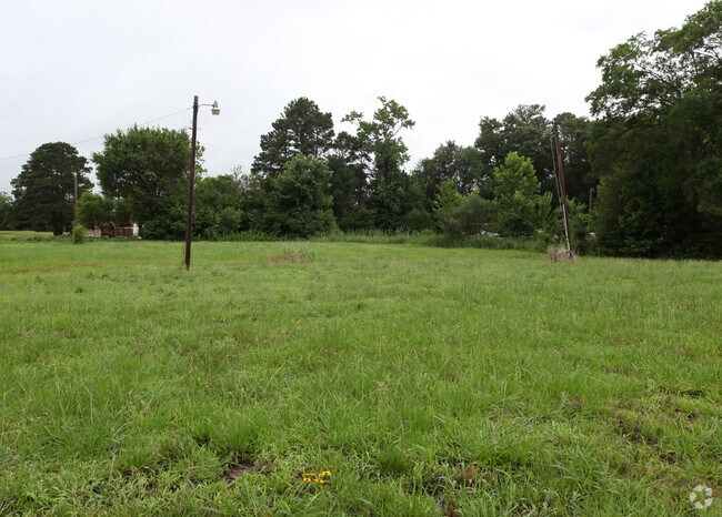
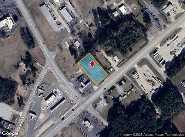
Property Record
2816 Us Highway 301 S, Wilson, NC 27893
NEARBY LISTINGS FOR SALE OR LEASE
Property Detail
2816 Us Highway 301 S
Wilson, NC
2816 US 301 HWY S L2 PATEL SUB 1.13AC 95 659SF DOT
3710-38-7833.000
Wilson
Residentialacreage
North Carolina
X
95
3720371000K
1.13 AC
2024
Rocky Mount/Wilson
2025
Other Market Areas
000402
DEMOGRAPHICS near 2816 Us Highway 301 S
1 Mile
3 Mile
5 Mile
2024 Total Population
733
20,143
48,069
2029 Population
736
20,325
48,354
Pop Growth 2024-2029
+ 0.41%
+ 0.90%
+ 0.59%
Average Age
41
41
41
2024 Total Households
289
8,440
19,969
HH Growth 2024-2029
+ 0.35%
+ 0.81%
+ 0.56%
Median Household Inc
$52,396
$36,989
$45,062
Avg Household Size
2.40
2.20
2.30
2024 Avg HH Vehicles
2.00
2.00
2.00
Median Home Value
$126,389
$117,327
$144,052
Median Year Built
1980
1977
1981
Nearby Places
Map Layers
Map Styles
 Street
 Aerial
- Restaurants
- Banks
- Shops
- Fitness
- Groceries
PUBLIC TRANSPORTATION
COMMUTER RAIL
Wilson (Carolinian - Amtrak, Palmetto - Amtrak)
DRIVE
WALK
Distance
Wilson (Carolinian - Amtrak, Palmetto - Amtrak)
6 min
3.2 mi
Freight Ports
Port of Morehead City
DRIVE
WALK
Distance
Port of Morehead City
164 min
124.8 mi
Nearby Properties
Address
Land Use
TOTAL SIZE
Lot Size
Zoning
Address
Land Use
TOTAL SIZE
Lot Size
Zoning
11,771 SF
31.78 AC
ICD
Address
Land Use
TOTAL SIZE
Lot Size
Zoning
220,639 SF
1.94 AC
CCMX
Address
Land Use
TOTAL SIZE
Lot Size
Zoning
98,777 SF
50 AC
ICD
Address
Land Use
TOTAL SIZE
Lot Size
Zoning
259,000 SF
69.97 AC
HI
Address
Land Use
TOTAL SIZE
Lot Size
Zoning
59,319 SF
1.01 AC
CCMX
Address
Land Use
TOTAL SIZE
Lot Size
Zoning
150,316 SF
10.97 AC
RMX
Address
Land Use
TOTAL SIZE
Lot Size
Zoning
80,000 SF
101.30 AC
HI
Address
Land Use
TOTAL SIZE
Lot Size
Zoning
185,515 SF
19.58 AC
HC
Address
Land Use
TOTAL SIZE
Lot Size
Zoning
25,888 SF
73.36 AC
LI
Address
Land Use
TOTAL SIZE
Lot Size
Zoning
192,420 SF
34.36 AC
HI
Address
Land Use
TOTAL SIZE
Lot Size
Zoning
91,637 SF
1.95 AC
CCMX
Address
Land Use
TOTAL SIZE
Lot Size
Zoning
133,549 SF
21.49 AC
HC
Address
Land Use
TOTAL SIZE
Lot Size
Zoning
1,944 SF
13.64 AC
GR6
Address
Land Use
TOTAL SIZE
Lot Size
Zoning
8,616 SF
40 AC
ICD
Address
Land Use
TOTAL SIZE
Lot Size
Zoning
12,560 SF
11.89 AC
HC
Address
Land Use
TOTAL SIZE
Lot Size
Zoning
3,900 SF
16.46 AC
RMX
Address
Land Use
TOTAL SIZE
Lot Size
Zoning
74,555 SF
2.37 AC
CCMX
Address
Land Use
TOTAL SIZE
Lot Size
Zoning
112,721 SF
22.04 AC
GC
Address
Land Use
TOTAL SIZE
Lot Size
Zoning
108,510 SF
1.47 AC
CCMX
Address
Land Use
TOTAL SIZE
Lot Size
Zoning
39,321 SF
5.55 AC
ICD
Address
Land Use
TOTAL SIZE
Lot Size
Zoning
9,548 SF
33.53 AC
LI
Address
Land Use
TOTAL SIZE
Lot Size
Zoning
2,464 SF
12.82 AC
ICD
Address
Land Use
TOTAL SIZE
Lot Size
Zoning
7,260 SF
6.99 AC
RMX
Address
Land Use
TOTAL SIZE
Lot Size
Zoning
16,350 SF
9.92 AC
SR4
Address
Land Use
TOTAL SIZE
Lot Size
Zoning
2,500 SF
34.70 AC
M2
Address
Land Use
TOTAL SIZE
Lot Size
Zoning
59,760 SF
16.60 AC
M1
Address
Land Use
TOTAL SIZE
Lot Size
Zoning
195,718 SF
36.18 AC
HI
Address
Land Use
TOTAL SIZE
Lot Size
Zoning
2,475 SF
10.62 AC
HC
Address
Land Use
TOTAL SIZE
Lot Size
Zoning
171,360 SF
1.78 AC
CCMX
Address
Land Use
TOTAL SIZE
Lot Size
Zoning
51,620 SF
5.71 AC
GR6
The World's #1 Commercial Real Estate Marketplace
Connect with us
© 2025 CoStar Group
The information above has been obtained from sources believed reliable. While we do not doubt its accuracy we have not verified it and make no guarantee, warranty or representation about it. It is your responsibility to independently confirm its accuracy and completeness. Any projections, opinions, assumptions, or estimates used are for example only and do not represent the current or future performance of the property. The value of this transaction to you depends on tax and other factors which should be evaluated by your tax, financial, and legal advisors. You and your advisors should conduct a careful, independent investigation of the property to determine to your satisfaction the suitability of the property for your needs.