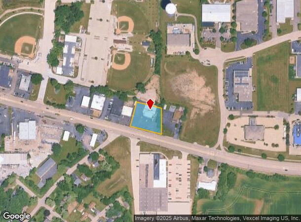
Property Record
2816 W Il Route 120, Mchenry, IL 60051
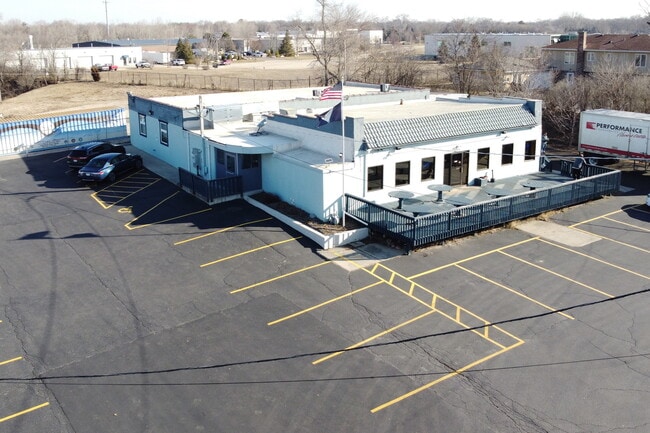
This Property Is For Sale
NEARBY LISTINGS FOR SALE OR LEASE
Property Detail
2816 W Il Route 120
Chicago-Naperville-Elgin, IL-IN-WI
Mchenry Plat No 7
09-25-354-022
DOC 2017R0017111 & 2016R0027880 LT 22 /EX W 60FT & EX RD/ CONWAYS SUB & .01A OF LT 8 LYING N OF & ADJ MCHENRY PLAT NO 7
Commercialnec
McHenry
X
Illinois
17111C0209J
22,8
2024
0.56 AC
2024
Far Northwest
870702
Chicago
5,448 SF
DEMOGRAPHICS near 2816 W Il Route 120
1 Mile
3 Mile
5 Mile
2024 Total Population
5,780
36,870
68,080
2029 Population
5,811
37,083
68,550
Pop Growth 2024-2029
+ 0.54%
+ 0.58%
+ 0.69%
Average Age
42
42
42
2024 Total Households
2,299
14,565
26,720
HH Growth 2024-2029
+ 0.52%
+ 0.55%
+ 0.68%
Median Household Inc
$84,943
$79,044
$83,591
Avg Household Size
2.50
2.50
2.50
2024 Avg HH Vehicles
2.00
2.00
2.00
Median Home Value
$239,414
$218,929
$230,518
Median Year Built
1980
1982
1986
Nearby Places
Map Layers
Map Styles
 Street
 Aerial
- Restaurants
- Banks
- Shops
- Fitness
- Groceries
PUBLIC TRANSPORTATION
COMMUTER RAIL
Mchenry Station (Union Pacific Northwest Line - Northeast Illinois Regional Commuter Railroad (Metra))
DRIVE
WALK
Distance
Mchenry Station (Union Pacific Northwest Line - Northeast Illinois Regional Commuter Railroad (Metra))
3 min
1.3 mi
Freight Ports
Port Milwaukee
DRIVE
WALK
Distance
Port Milwaukee
83 min
65.1 mi
Nearby Properties
Address
Land Use
TOTAL SIZE
Lot Size
Zoning
Address
Land Use
TOTAL SIZE
Lot Size
Zoning
20.51 AC
Address
Land Use
TOTAL SIZE
Lot Size
Zoning
5,000 SF
30.62 AC
Address
Land Use
TOTAL SIZE
Lot Size
Zoning
10.75 AC
Address
Land Use
TOTAL SIZE
Lot Size
Zoning
279,418 SF
12.26 AC
Address
Land Use
TOTAL SIZE
Lot Size
Zoning
376,110 SF
13.46 AC
Address
Land Use
TOTAL SIZE
Lot Size
Zoning
54,986 SF
5.83 AC
Address
Land Use
TOTAL SIZE
Lot Size
Zoning
47,440 SF
3.59 AC
Address
Land Use
TOTAL SIZE
Lot Size
Zoning
191,960 SF
19 AC
Address
Land Use
TOTAL SIZE
Lot Size
Zoning
185,809 SF
21 AC
Address
Land Use
TOTAL SIZE
Lot Size
Zoning
10,082 SF
0.80 AC
Address
Land Use
TOTAL SIZE
Lot Size
Zoning
124,114 SF
6.05 AC
Address
Land Use
TOTAL SIZE
Lot Size
Zoning
218,524 SF
12.92 AC
Address
Land Use
TOTAL SIZE
Lot Size
Zoning
0.50 AC
Address
Land Use
TOTAL SIZE
Lot Size
Zoning
236,501 SF
10 AC
Address
Land Use
TOTAL SIZE
Lot Size
Zoning
233,785 SF
15.54 AC
Address
Land Use
TOTAL SIZE
Lot Size
Zoning
21,686 SF
0.90 AC
Address
Land Use
TOTAL SIZE
Lot Size
Zoning
267,134 SF
5.59 AC
Address
Land Use
TOTAL SIZE
Lot Size
Zoning
81,264 SF
0.50 AC
Address
Land Use
TOTAL SIZE
Lot Size
Zoning
68,880 SF
13.39 AC
Address
Land Use
TOTAL SIZE
Lot Size
Zoning
72,624 SF
2.80 AC
Address
Land Use
TOTAL SIZE
Lot Size
Zoning
3.11 AC
Address
Land Use
TOTAL SIZE
Lot Size
Zoning
115,923 SF
12 AC
Address
Land Use
TOTAL SIZE
Lot Size
Zoning
83,570 SF
3 AC
Address
Land Use
TOTAL SIZE
Lot Size
Zoning
83,744 SF
8.06 AC
Address
Land Use
TOTAL SIZE
Lot Size
Zoning
46,824 SF
6.68 AC
Address
Land Use
TOTAL SIZE
Lot Size
Zoning
66,380 SF
5.36 AC
Address
Land Use
TOTAL SIZE
Lot Size
Zoning
64,614 SF
5 AC
Address
Land Use
TOTAL SIZE
Lot Size
Zoning
57,000 SF
0.86 AC
Address
Land Use
TOTAL SIZE
Lot Size
Zoning
94,900 SF
3.84 AC
Address
Land Use
TOTAL SIZE
Lot Size
Zoning
1,704 SF
0.25 AC
The World's #1 Commercial Real Estate Marketplace
Connect with us
© 2025 CoStar Group
The information above has been obtained from sources believed reliable. While we do not doubt its accuracy we have not verified it and make no guarantee, warranty or representation about it. It is your responsibility to independently confirm its accuracy and completeness. Any projections, opinions, assumptions, or estimates used are for example only and do not represent the current or future performance of the property. The value of this transaction to you depends on tax and other factors which should be evaluated by your tax, financial, and legal advisors. You and your advisors should conduct a careful, independent investigation of the property to determine to your satisfaction the suitability of the property for your needs.