Property Record
2819 Dahlia St, Klamath Falls, OR 97601
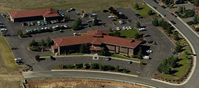
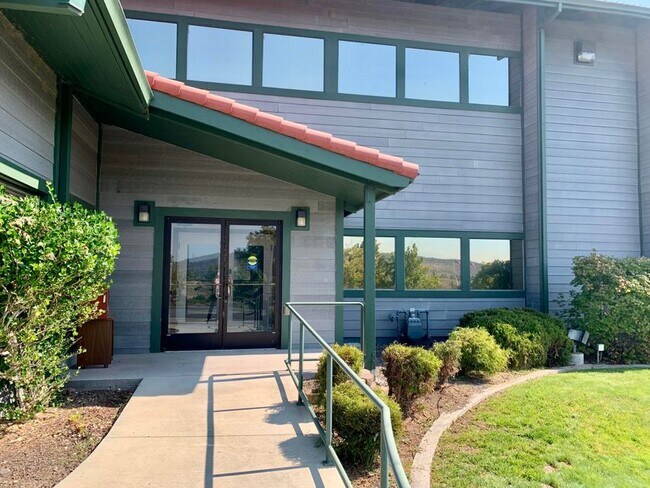

Property Detail
2819 Dahlia St
Klamath Falls, OR
Klamath
R169016
Oregon
Officebuilding
2.27 AC
PUD
Oregon East Area
B and X Area of moderate flood hazard, usually the area between the limits of the 100-year and 500-year floods.
Other Market Areas
26,475 SF
NEARBY LISTINGS FOR SALE OR LEASE
DEMOGRAPHICS near 2819 Dahlia St
1 mile
3 mile
5 mile
2025 Total Population
4,029
18,034
33,687
2030 Population
4,055
18,070
33,778
Pop Growth 2025-2030
+ 0.65%
+ 0.20%
+ 0.27%
Average Age
38
39
40
2025 Total Households
1,502
7,492
13,937
HH Growth 2025-2030
+ 0.13%
(0.04%)
+ 0.09%
Median Household Inc
$47,599
$40,034
$42,384
Avg Household Size
2.30
2.20
2.30
2025 Avg HH Vehicles
2.00
2.00
2.00
Median Home Value
$271,341
$252,250
$246,174
Median Year Built
1970
1960
1967
Nearby Places
Map Layers
Map Styles
 Street
 Aerial
Layers
 Traffic
 Biking
Places
Listings with unknown addresses are not visible on the map
- Restaurants
- Banks
- Shops
- Fitness
- Groceries
PUBLIC TRANSPORTATION
COMMUTER RAIL
Drive
Walk
Distance
5 min
2.4 mi
SALE & LEASE HISTORY
LISTING DATE
SALE/LEASE

Sep 28, 2021
For Lease
Sep 28, 2021
For Sale
Nearby Properties
Address
Land Use
TOTAL SIZE
Lot Size
Zoning
Address
Land Use
TOTAL SIZE
Lot Size
Zoning
210,396 SF
12.99 AC
PUD
Address
Land Use
TOTAL SIZE
Lot Size
Zoning
15,313 SF
1.63 AC
PUD
Address
Land Use
TOTAL SIZE
Lot Size
Zoning
530,947 SF
156.42 AC
PUD
Address
Land Use
TOTAL SIZE
Lot Size
Zoning
Address
Land Use
TOTAL SIZE
Lot Size
Zoning
784 SF
5.73 AC
I
Address
Land Use
TOTAL SIZE
Lot Size
Zoning
3.92 AC
MU
Address
Land Use
TOTAL SIZE
Lot Size
Zoning
66,904 SF
36.90 AC
PF
Address
Land Use
TOTAL SIZE
Lot Size
Zoning
145,149 SF
4.90 AC
PF
Address
Land Use
TOTAL SIZE
Lot Size
Zoning
57,008 SF
1.43 AC
PF
Address
Land Use
TOTAL SIZE
Lot Size
Zoning
10.33 AC
I
Address
Land Use
TOTAL SIZE
Lot Size
Zoning
1 SF
11.75 AC
Address
Land Use
TOTAL SIZE
Lot Size
Zoning
Address
Land Use
TOTAL SIZE
Lot Size
Zoning
98,373 SF
0.69 AC
PUD
Address
Land Use
TOTAL SIZE
Lot Size
Zoning
61,045 SF
2.44 AC
A
Address
Land Use
TOTAL SIZE
Lot Size
Zoning
41,978 SF
23.54 AC
PUD
Address
Land Use
TOTAL SIZE
Lot Size
Zoning
7,432 SF
0.16 AC
A
Address
Land Use
TOTAL SIZE
Lot Size
Zoning
2.46 AC
MU
Address
Land Use
TOTAL SIZE
Lot Size
Zoning
41,938 SF
1.45 AC
PF
Address
Land Use
TOTAL SIZE
Lot Size
Zoning
26,645 SF
1.66 AC
A
Address
Land Use
TOTAL SIZE
Lot Size
Zoning
2,638 SF
8.17 AC
A
Address
Land Use
TOTAL SIZE
Lot Size
Zoning
30.31 AC
I
Address
Land Use
TOTAL SIZE
Lot Size
Zoning
4.06 AC
PF
Address
Land Use
TOTAL SIZE
Lot Size
Zoning
16,952 SF
2.28 AC
GC
Address
Land Use
TOTAL SIZE
Lot Size
Zoning
2.81 AC
PUD
Address
Land Use
TOTAL SIZE
Lot Size
Zoning
5,382 SF
1.10 AC
GC
Address
Land Use
TOTAL SIZE
Lot Size
Zoning
54,519 SF
4.36 AC
PUD
Address
Land Use
TOTAL SIZE
Lot Size
Zoning
24.16 AC
LI
Address
Land Use
TOTAL SIZE
Lot Size
Zoning
39,515 SF
3.11 AC
PUD
The World's #1 Commercial Real Estate Marketplace
Connect with us
© 2026 CoStar Group
The information above has been obtained from sources believed reliable. While we do not doubt its accuracy we have not verified it and make no guarantee, warranty or representation about it. It is your responsibility to independently confirm its accuracy and completeness. Any projections, opinions, assumptions, or estimates used are for example only and do not represent the current or future performance of the property. The value of this transaction to you depends on tax and other factors which should be evaluated by your tax, financial, and legal advisors. You and your advisors should conduct a careful, independent investigation of the property to determine to your satisfaction the suitability of the property for your needs.