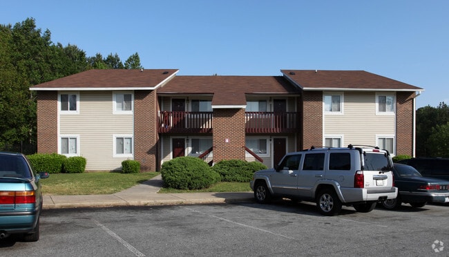
Property Record
2819 Rochelle St, Durham, NC 27703


Save to a Folder
{{folder.Name}}
{{folder.ListingIds.length}} Properties
{{folder.ListingIds.length}} Property
Create a New Folder
Property Detail
2819 Rochelle St
131631
COLONY MANOR/BLK:F/LT#01 DBA/ROCHELLE MANOR APTS PL:000000-000000
Gardenaptcourtapt5plusunits
DURHAM
RS-M
North Carolina
B and X Area of moderate flood hazard, usually the area between the limits of the 100-year and 500-year floods.
1
2025
14.33 AC
2025
Eastern Durham
001802
Raleigh/Durham
81,656 SF
Durham-Chapel Hill, NC
NEARBY LISTINGS FOR SALE OR LEASE
DEMOGRAPHICS near 2819 Rochelle St
1 mile
3 mile
5 mile
2025 Total Population
7,922
67,819
162,936
2030 Population
8,457
72,329
173,648
Pop Growth 2025-2030
+ 6.75%
+ 6.65%
+ 6.57%
Average Age
36
37
37
2025 Total Households
2,631
24,924
63,839
HH Growth 2025-2030
+ 6.99%
+ 7.02%
+ 7.05%
Median Household Inc
$69,013
$71,272
$73,172
Avg Household Size
2.90
2.60
2.30
2025 Avg HH Vehicles
2.00
2.00
2.00
Median Home Value
$264,204
$338,881
$389,607
Median Year Built
1985
1989
1990
Nearby Places
Map Layers
Map Styles
 Street
 Aerial
Layers
 Traffic
 Biking
Places
Listings with unknown addresses are not visible on the map
- Restaurants
- Banks
- Shops
- Fitness
- Groceries
PUBLIC TRANSPORTATION
COMMUTER RAIL
Durham Amtrak Station (Carolinian - Amtrak, Piedmont - Amtrak)
Drive
Walk
Distance
Durham Amtrak Station (Carolinian - Amtrak, Piedmont - Amtrak)
9 min
3.6 mi
AIRPORT
Raleigh-Durham International
Drive
Walk
Distance
Raleigh-Durham International
21 min
11.2 mi
Freight Ports
Virginia Port Authority - Richmond
Drive
Walk
Distance
Virginia Port Authority - Richmond
167 min
145.9 mi
Nearby Properties
Address
Land Use
TOTAL SIZE
Lot Size
Zoning
Address
Land Use
TOTAL SIZE
Lot Size
Zoning
839,237 SF
9.84 AC
DD-C
Address
Land Use
TOTAL SIZE
Lot Size
Zoning
310,825 SF
3.20 AC
DD-C
Address
Land Use
TOTAL SIZE
Lot Size
Zoning
3.38 AC
DD-C
Address
Land Use
TOTAL SIZE
Lot Size
Zoning
171,375 SF
3.80 AC
DD-C
Address
Land Use
TOTAL SIZE
Lot Size
Zoning
69,430 SF
2.61 AC
DD-C
Address
Land Use
TOTAL SIZE
Lot Size
Zoning
230,275 SF
2.12 AC
DD-C
Address
Land Use
TOTAL SIZE
Lot Size
Zoning
265,592 SF
2.04 AC
DD-C
Address
Land Use
TOTAL SIZE
Lot Size
Zoning
262,593 SF
2.73 AC
DD-C
Address
Land Use
TOTAL SIZE
Lot Size
Zoning
410,000 SF
31.41 AC
IL
Address
Land Use
TOTAL SIZE
Lot Size
Zoning
144,812 SF
1.44 AC
DD-C
Address
Land Use
TOTAL SIZE
Lot Size
Zoning
1,524 SF
11.97 AC
CG(D)
Address
Land Use
TOTAL SIZE
Lot Size
Zoning
69.37 AC
IL
Address
Land Use
TOTAL SIZE
Lot Size
Zoning
260,000 SF
35.58 AC
I,IL
Address
Land Use
TOTAL SIZE
Lot Size
Zoning
40.81 AC
IL
Address
Land Use
TOTAL SIZE
Lot Size
Zoning
103,784 SF
0.84 AC
Address
Land Use
TOTAL SIZE
Lot Size
Zoning
305,872 SF
4.51 AC
DD-S1
Address
Land Use
TOTAL SIZE
Lot Size
Zoning
303,996 SF
0.98 AC
DD-S1
Address
Land Use
TOTAL SIZE
Lot Size
Zoning
11,520 SF
1.18 AC
DD-S1
Address
Land Use
TOTAL SIZE
Lot Size
Zoning
293,502 SF
1.46 AC
DD-C
Address
Land Use
TOTAL SIZE
Lot Size
Zoning
274,399 SF
19.36 AC
IL
Address
Land Use
TOTAL SIZE
Lot Size
Zoning
114,840 SF
1.03 AC
DD-S1
Address
Land Use
TOTAL SIZE
Lot Size
Zoning
15.47 AC
RS-M(D)
Address
Land Use
TOTAL SIZE
Lot Size
Zoning
131,100 SF
2.19 AC
DD-C
Address
Land Use
TOTAL SIZE
Lot Size
Zoning
69,258 SF
8.82 AC
DD-S1,DD-S
Address
Land Use
TOTAL SIZE
Lot Size
Zoning
183,892 SF
1.13 AC
DD-C
Address
Land Use
TOTAL SIZE
Lot Size
Zoning
150,752 SF
1.48 AC
DD-C
Address
Land Use
TOTAL SIZE
Lot Size
Zoning
156,441 SF
2.43 AC
DD-C
Address
Land Use
TOTAL SIZE
Lot Size
Zoning
112,065 SF
0.84 AC
Address
Land Use
TOTAL SIZE
Lot Size
Zoning
142,984 SF
0.38 AC
DD-C
Address
Land Use
TOTAL SIZE
Lot Size
Zoning
177,395 SF
7.10 AC
DD-S2
The World's #1 Commercial Real Estate Marketplace
Connect with us
© 2026 CoStar Group
The information above has been obtained from sources believed reliable. While we do not doubt its accuracy we have not verified it and make no guarantee, warranty or representation about it. It is your responsibility to independently confirm its accuracy and completeness. Any projections, opinions, assumptions, or estimates used are for example only and do not represent the current or future performance of the property. The value of this transaction to you depends on tax and other factors which should be evaluated by your tax, financial, and legal advisors. You and your advisors should conduct a careful, independent investigation of the property to determine to your satisfaction the suitability of the property for your needs.