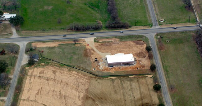
Property Record
2819 Weatherford Hwy, Granbury, TX 76049

Property Detail
2819 Weatherford Hwy
R000016262
ACRES: 3.910 BLK: 5 SUBD: LAGUNA TRES EST
Commercialnec
HOOD
B and X Area of moderate flood hazard, usually the area between the limits of the 100-year and 500-year floods.
Texas
2025
3.91 AC
2025
Hood County
160218
Dallas/Ft Worth
6,272 SF
Granbury, TX
NEARBY LISTINGS FOR SALE OR LEASE
DEMOGRAPHICS near 2819 Weatherford Hwy
1 mile
3 mile
5 mile
2025 Total Population
2,712
14,763
34,611
2030 Population
2,960
16,112
37,697
Pop Growth 2025-2030
+ 9.14%
+ 9.14%
+ 8.92%
Average Age
46
44
44
2025 Total Households
1,071
5,728
13,897
HH Growth 2025-2030
+ 8.96%
+ 9.03%
+ 8.69%
Median Household Inc
$100,554
$79,331
$72,926
Avg Household Size
2.40
2.50
2.40
2025 Avg HH Vehicles
2.00
2.00
2.00
Median Home Value
$467,316
$404,534
$327,432
Median Year Built
1999
1993
1994
Nearby Places
Map Layers
Map Styles
 Street
 Aerial
Layers
 Traffic
 Biking
Places
Listings with unknown addresses are not visible on the map
- Restaurants
- Banks
- Shops
- Fitness
- Groceries
Nearby Properties
Address
Land Use
TOTAL SIZE
Lot Size
Zoning
Address
Land Use
TOTAL SIZE
Lot Size
Zoning
4,103 SF
11.68 AC
Address
Land Use
TOTAL SIZE
Lot Size
Zoning
47,280 SF
95.51 AC
Address
Land Use
TOTAL SIZE
Lot Size
Zoning
116,121 SF
4.33 AC
Address
Land Use
TOTAL SIZE
Lot Size
Zoning
10,000 SF
7.74 AC
Address
Land Use
TOTAL SIZE
Lot Size
Zoning
65,456 SF
21.69 AC
Address
Land Use
TOTAL SIZE
Lot Size
Zoning
47,868 SF
39.29 AC
Address
Land Use
TOTAL SIZE
Lot Size
Zoning
82,664 SF
2.60 AC
Address
Land Use
TOTAL SIZE
Lot Size
Zoning
68,829 SF
Address
Land Use
TOTAL SIZE
Lot Size
Zoning
71,245 SF
9.70 AC
Address
Land Use
TOTAL SIZE
Lot Size
Zoning
68,198 SF
15 AC
Address
Land Use
TOTAL SIZE
Lot Size
Zoning
26,476 SF
3.71 AC
Address
Land Use
TOTAL SIZE
Lot Size
Zoning
52,239 SF
20 AC
Address
Land Use
TOTAL SIZE
Lot Size
Zoning
51,193 SF
10.05 AC
Address
Land Use
TOTAL SIZE
Lot Size
Zoning
29,532 SF
43.39 AC
Address
Land Use
TOTAL SIZE
Lot Size
Zoning
19,257 SF
2.07 AC
Address
Land Use
TOTAL SIZE
Lot Size
Zoning
6,886 SF
8 AC
Address
Land Use
TOTAL SIZE
Lot Size
Zoning
51,193 SF
5 AC
Address
Land Use
TOTAL SIZE
Lot Size
Zoning
45,730 SF
7.56 AC
Address
Land Use
TOTAL SIZE
Lot Size
Zoning
17,272 SF
5.43 AC
Address
Land Use
TOTAL SIZE
Lot Size
Zoning
6,512 SF
3.88 AC
Address
Land Use
TOTAL SIZE
Lot Size
Zoning
54,173 SF
6.04 AC
Address
Land Use
TOTAL SIZE
Lot Size
Zoning
40.10 AC
Address
Land Use
TOTAL SIZE
Lot Size
Zoning
2,030 SF
154.38 AC
Address
Land Use
TOTAL SIZE
Lot Size
Zoning
9,468 SF
10.51 AC
Address
Land Use
TOTAL SIZE
Lot Size
Zoning
13,250 SF
0.30 AC
Address
Land Use
TOTAL SIZE
Lot Size
Zoning
29,633 SF
1.16 AC
Address
Land Use
TOTAL SIZE
Lot Size
Zoning
1,680 SF
162.38 AC
Address
Land Use
TOTAL SIZE
Lot Size
Zoning
10,511 SF
0.75 AC
Address
Land Use
TOTAL SIZE
Lot Size
Zoning
11,850 SF
0.34 AC
Address
Land Use
TOTAL SIZE
Lot Size
Zoning
64,617 SF
7.56 AC
The World's #1 Commercial Real Estate Marketplace
Connect with us
© 2026 CoStar Group
The information above has been obtained from sources believed reliable. While we do not doubt its accuracy we have not verified it and make no guarantee, warranty or representation about it. It is your responsibility to independently confirm its accuracy and completeness. Any projections, opinions, assumptions, or estimates used are for example only and do not represent the current or future performance of the property. The value of this transaction to you depends on tax and other factors which should be evaluated by your tax, financial, and legal advisors. You and your advisors should conduct a careful, independent investigation of the property to determine to your satisfaction the suitability of the property for your needs.