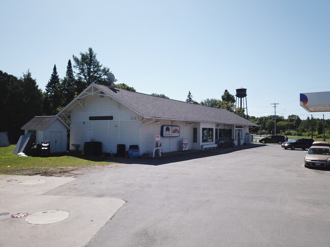
Property Record
282 Main St, Richland, NY 13144


NEARBY LISTINGS FOR SALE OR LEASE
-
-
View all Richland listings for sale on LoopNet.com
Property Detail
282 Main St
355089-061-001-0004-001-001-0000
L-155 487-031-000
Servicestation
Oswego
X
New York
36075C0185G
1.010
2025
1.08 AC
2024
Oswego County
020304
Syracuse
3,296 SF
Syracuse, NY
DEMOGRAPHICS near 282 Main St
1 Mile
3 Mile
5 Mile
2024 Total Population
475
1,610
5,875
2029 Population
473
1,600
5,838
Pop Growth 2024-2029
(0.42%)
(0.62%)
(0.63%)
Average Age
41
41
42
2024 Total Households
175
593
2,373
HH Growth 2024-2029
(0.57%)
(0.67%)
(0.67%)
Median Household Inc
$51,111
$54,285
$54,555
Avg Household Size
2.60
2.60
2.40
2024 Avg HH Vehicles
3.00
2.00
2.00
Median Home Value
$103,077
$103,809
$130,515
Median Year Built
1960
1970
1972
Nearby Places
Map Layers
Map Styles
 Street
 Aerial
- Restaurants
- Banks
- Shops
- Fitness
- Groceries
SALE & LEASE HISTORY
LISTING DATE
SALE/LEASE

Sep 26, 2019
For Sale
May 21, 2020
For Sale
Nearby Properties
Address
Land Use
TOTAL SIZE
Lot Size
Zoning
Address
Land Use
TOTAL SIZE
Lot Size
Zoning
5,600 SF
21.48 AC
Address
Land Use
TOTAL SIZE
Lot Size
Zoning
166,960 SF
152.14 AC
06 - INDUS
Address
Land Use
TOTAL SIZE
Lot Size
Zoning
312.74 AC
NOT-WF
Address
Land Use
TOTAL SIZE
Lot Size
Zoning
4,896 SF
126 AC
Address
Land Use
TOTAL SIZE
Lot Size
Zoning
18,868 SF
17.42 AC
02 - SINGL
Address
Land Use
TOTAL SIZE
Lot Size
Zoning
4,368 SF
4.96 AC
Address
Land Use
TOTAL SIZE
Lot Size
Zoning
12,052 SF
28.12 AC
02 - SINGL
Address
Land Use
TOTAL SIZE
Lot Size
Zoning
1,650 SF
10.52 AC
02 - SINGL
Address
Land Use
TOTAL SIZE
Lot Size
Zoning
1,985 SF
10.30 AC
Address
Land Use
TOTAL SIZE
Lot Size
Zoning
4,032 SF
2.07 AC
Address
Land Use
TOTAL SIZE
Lot Size
Zoning
2,648 SF
3.40 AC
01 - NOT Z
Address
Land Use
TOTAL SIZE
Lot Size
Zoning
1,960 SF
1.50 AC
01 - NOT Z
Address
Land Use
TOTAL SIZE
Lot Size
Zoning
23,000 SF
40.80 AC
02 - SINGL
Address
Land Use
TOTAL SIZE
Lot Size
Zoning
7,776 SF
120.94 AC
Address
Land Use
TOTAL SIZE
Lot Size
Zoning
1,924 SF
11.50 AC
Address
Land Use
TOTAL SIZE
Lot Size
Zoning
7,200 SF
12.38 AC
Address
Land Use
TOTAL SIZE
Lot Size
Zoning
363.65 AC
02 - SINGL
Address
Land Use
TOTAL SIZE
Lot Size
Zoning
2,004 SF
119.54 AC
02 - SINGL
Address
Land Use
TOTAL SIZE
Lot Size
Zoning
2,245 SF
28 AC
Address
Land Use
TOTAL SIZE
Lot Size
Zoning
3,600 SF
Address
Land Use
TOTAL SIZE
Lot Size
Zoning
1,225 SF
3.46 AC
Address
Land Use
TOTAL SIZE
Lot Size
Zoning
6,790 SF
1.77 AC
Address
Land Use
TOTAL SIZE
Lot Size
Zoning
3,464 SF
213.27 AC
02 - SINGL
Address
Land Use
TOTAL SIZE
Lot Size
Zoning
207 AC
Address
Land Use
TOTAL SIZE
Lot Size
Zoning
3,218 SF
05 - COMME
Address
Land Use
TOTAL SIZE
Lot Size
Zoning
7,925 SF
1.64 AC
05 - COMME
Address
Land Use
TOTAL SIZE
Lot Size
Zoning
6,528 SF
2 AC
05 - COMME
Address
Land Use
TOTAL SIZE
Lot Size
Zoning
3,100 SF
1.10 AC
Address
Land Use
TOTAL SIZE
Lot Size
Zoning
1,680 SF
3.60 AC
The World's #1 Commercial Real Estate Marketplace
Connect with us
© 2025 CoStar Group
The information above has been obtained from sources believed reliable. While we do not doubt its accuracy we have not verified it and make no guarantee, warranty or representation about it. It is your responsibility to independently confirm its accuracy and completeness. Any projections, opinions, assumptions, or estimates used are for example only and do not represent the current or future performance of the property. The value of this transaction to you depends on tax and other factors which should be evaluated by your tax, financial, and legal advisors. You and your advisors should conduct a careful, independent investigation of the property to determine to your satisfaction the suitability of the property for your needs.