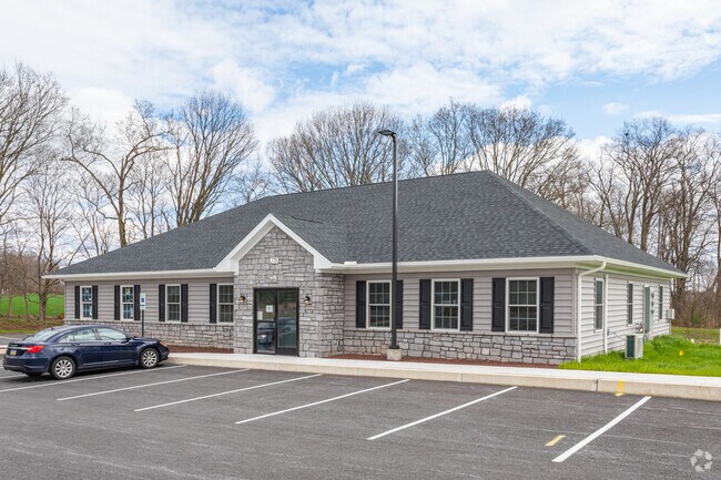
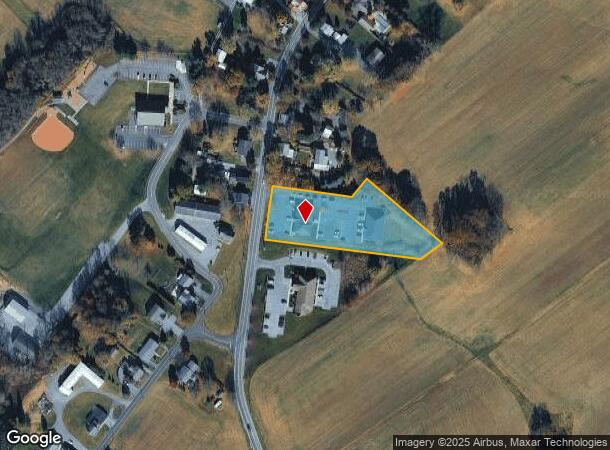
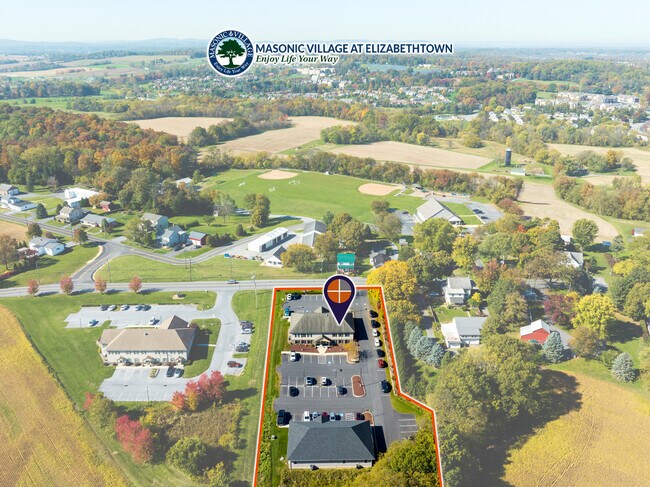
Property Record
282 Maytown Rd, Elizabethtown, PA 17022
NEARBY LISTINGS FOR SALE OR LEASE
Property Detail
282 Maytown Rd
Lancaster, PA
Kurtz Prop
160-04891-0-0000
282 MAYTOWN RD
Officebuilding
Lancaster
X
Pennsylvania
42071C0113F
2
2024
1.78 AC
2025
Lancaster County
010804
Philadelphia
7,848 SF
DEMOGRAPHICS near 282 Maytown Rd
1 Mile
3 Mile
5 Mile
2024 Total Population
6,234
28,482
45,694
2029 Population
6,327
28,723
46,051
Pop Growth 2024-2029
+ 1.49%
+ 0.85%
+ 0.78%
Average Age
45
42
42
2024 Total Households
2,590
10,956
17,600
HH Growth 2024-2029
+ 1.66%
+ 0.98%
+ 0.89%
Median Household Inc
$63,448
$74,412
$77,511
Avg Household Size
2.10
2.40
2.40
2024 Avg HH Vehicles
2.00
2.00
2.00
Median Home Value
$233,937
$247,441
$243,488
Median Year Built
1968
1983
1984
Nearby Places
Map Layers
Map Styles
 Street
 Aerial
- Restaurants
- Banks
- Shops
- Fitness
- Groceries
PUBLIC TRANSPORTATION
COMMUTER RAIL
DRIVE
WALK
Distance
4 min
1.8 mi
DRIVE
WALK
Distance
10 min
6.0 mi
AIRPORT
Harrisburg International
DRIVE
WALK
Distance
Harrisburg International
21 min
11.7 mi
Freight Ports
Port Newark Container Terminal
DRIVE
WALK
Distance
Port Newark Container Terminal
103 min
66.6 mi
SALE & LEASE HISTORY
LISTING DATE
SALE/LEASE

Jan 09, 2024
For Lease
Feb 13, 2017
For Lease
Apr 06, 2018
For Lease
Nearby Properties
Address
Land Use
TOTAL SIZE
Lot Size
Zoning
Address
Land Use
TOTAL SIZE
Lot Size
Zoning
1,506,831 SF
1,061.90 AC
INS
Address
Land Use
TOTAL SIZE
Lot Size
Zoning
531,244 SF
100.20 AC
Address
Land Use
TOTAL SIZE
Lot Size
Zoning
705,686 SF
90.80 AC
Address
Land Use
TOTAL SIZE
Lot Size
Zoning
991,031 SF
91.47 AC
Address
Land Use
TOTAL SIZE
Lot Size
Zoning
2,160 SF
72.40 AC
Address
Land Use
TOTAL SIZE
Lot Size
Zoning
463,991 SF
89.23 AC
Address
Land Use
TOTAL SIZE
Lot Size
Zoning
218,686 SF
6.79 AC
MU
Address
Land Use
TOTAL SIZE
Lot Size
Zoning
320,000 SF
27.99 AC
Address
Land Use
TOTAL SIZE
Lot Size
Zoning
154,112 SF
18.92 AC
Address
Land Use
TOTAL SIZE
Lot Size
Zoning
200,892 SF
16.25 AC
R3
Address
Land Use
TOTAL SIZE
Lot Size
Zoning
441,646 SF
59.55 AC
I-2
Address
Land Use
TOTAL SIZE
Lot Size
Zoning
85,268 SF
34.90 AC
Address
Land Use
TOTAL SIZE
Lot Size
Zoning
138,828 SF
17.09 AC
Address
Land Use
TOTAL SIZE
Lot Size
Zoning
303,449 SF
42.16 AC
I
Address
Land Use
TOTAL SIZE
Lot Size
Zoning
172,116 SF
248 AC
IN
Address
Land Use
TOTAL SIZE
Lot Size
Zoning
144,000 SF
22.46 AC
I
Address
Land Use
TOTAL SIZE
Lot Size
Zoning
127,425 SF
12.69 AC
Address
Land Use
TOTAL SIZE
Lot Size
Zoning
495,816 SF
26.02 AC
I-G
Address
Land Use
TOTAL SIZE
Lot Size
Zoning
100,368 SF
7.71 AC
Address
Land Use
TOTAL SIZE
Lot Size
Zoning
23,170 SF
107.91 AC
R
Address
Land Use
TOTAL SIZE
Lot Size
Zoning
37,911 SF
14.40 AC
RT
Address
Land Use
TOTAL SIZE
Lot Size
Zoning
41,069 SF
3.12 AC
R1
Address
Land Use
TOTAL SIZE
Lot Size
Zoning
31,445 SF
10.70 AC
INS
Address
Land Use
TOTAL SIZE
Lot Size
Zoning
61,504 SF
6.64 AC
Address
Land Use
TOTAL SIZE
Lot Size
Zoning
71,550 SF
7.05 AC
Address
Land Use
TOTAL SIZE
Lot Size
Zoning
53,048 SF
5 AC
R-2
Address
Land Use
TOTAL SIZE
Lot Size
Zoning
44,610 SF
10.58 AC
R-2
Address
Land Use
TOTAL SIZE
Lot Size
Zoning
160,545 SF
9.54 AC
C-G
Address
Land Use
TOTAL SIZE
Lot Size
Zoning
Address
Land Use
TOTAL SIZE
Lot Size
Zoning
32,460 SF
12.57 AC
The World's #1 Commercial Real Estate Marketplace
Connect with us
© 2025 CoStar Group
The information above has been obtained from sources believed reliable. While we do not doubt its accuracy we have not verified it and make no guarantee, warranty or representation about it. It is your responsibility to independently confirm its accuracy and completeness. Any projections, opinions, assumptions, or estimates used are for example only and do not represent the current or future performance of the property. The value of this transaction to you depends on tax and other factors which should be evaluated by your tax, financial, and legal advisors. You and your advisors should conduct a careful, independent investigation of the property to determine to your satisfaction the suitability of the property for your needs.