Property Record
282 Route 72, Barnegat, NJ 08005


NEARBY LISTINGS FOR SALE OR LEASE
-
-
View all Barnegat listings for sale on LoopNet.com
Property Detail
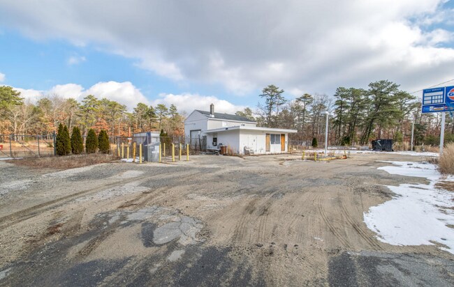
282 Route 72
01-00054-0000-00004
2.41 AC GULF
Commercialnec
Ocean
X
New Jersey
34029C0390F
4
2024
2.41 AC
2025
Ocean County
734004
Northern New Jersey
960 SF
New York-Jersey City-White Plains, NY-NJ
DEMOGRAPHICS near 282 Route 72
1 Mile
3 Mile
5 Mile
2024 Total Population
50
5,571
28,693
2029 Population
55
6,060
30,693
Pop Growth 2024-2029
+ 10.00%
+ 8.78%
+ 6.97%
Average Age
61
56
45
2024 Total Households
27
2,694
11,217
HH Growth 2024-2029
+ 7.41%
+ 8.09%
+ 6.55%
Median Household Inc
$57,499
$73,141
$87,089
Avg Household Size
1.90
2.00
2.50
2024 Avg HH Vehicles
2.00
2.00
2.00
Median Home Value
$312,500
$301,342
$305,678
Median Year Built
2006
2003
1996
Nearby Places
Map Layers
Map Styles
 Street
 Aerial
- Restaurants
- Banks
- Shops
- Fitness
- Groceries
PUBLIC TRANSPORTATION
AIRPORT
Atlantic City International
DRIVE
WALK
Distance
Atlantic City International
63 min
34.8 mi
Freight Ports
Port of Philadelphia
DRIVE
WALK
Distance
Port of Philadelphia
59 min
47.5 mi
SALE & LEASE HISTORY
LISTING DATE
SALE/LEASE

Sep 02, 2020
For Sale
Dec 19, 2016
For Sale
Nearby Properties
Address
Land Use
TOTAL SIZE
Lot Size
Zoning
Address
Land Use
TOTAL SIZE
Lot Size
Zoning
3,532 SF
100.06 AC
MH
Address
Land Use
TOTAL SIZE
Lot Size
Zoning
1,440 SF
71.85 AC
MH
Address
Land Use
TOTAL SIZE
Lot Size
Zoning
919.95 AC
PF
Address
Land Use
TOTAL SIZE
Lot Size
Zoning
4,276 SF
42.71 AC
PF
Address
Land Use
TOTAL SIZE
Lot Size
Zoning
1,449.26 AC
PA
Address
Land Use
TOTAL SIZE
Lot Size
Zoning
383.35 AC
PA
Address
Land Use
TOTAL SIZE
Lot Size
Zoning
3,188 SF
34.52 AC
PV
Address
Land Use
TOTAL SIZE
Lot Size
Zoning
25.60 AC
P-CC
Address
Land Use
TOTAL SIZE
Lot Size
Zoning
1,710 SF
13.96 AC
FO
Address
Land Use
TOTAL SIZE
Lot Size
Zoning
12.16 AC
PF
Address
Land Use
TOTAL SIZE
Lot Size
Zoning
289.36 AC
PF
Address
Land Use
TOTAL SIZE
Lot Size
Zoning
274.37 AC
PF
Address
Land Use
TOTAL SIZE
Lot Size
Zoning
14,457 SF
5 AC
FO
Address
Land Use
TOTAL SIZE
Lot Size
Zoning
8,314 SF
2 AC
PF
Address
Land Use
TOTAL SIZE
Lot Size
Zoning
Address
Land Use
TOTAL SIZE
Lot Size
Zoning
3,000 SF
122.83 AC
PA
Address
Land Use
TOTAL SIZE
Lot Size
Zoning
4,458 SF
2 AC
FO
Address
Land Use
TOTAL SIZE
Lot Size
Zoning
5,344 SF
1 AC
PVFO
Address
Land Use
TOTAL SIZE
Lot Size
Zoning
584.30 AC
S
Address
Land Use
TOTAL SIZE
Lot Size
Zoning
864 SF
17.71 AC
PVFO
Address
Land Use
TOTAL SIZE
Lot Size
Zoning
159.91 AC
PF
Address
Land Use
TOTAL SIZE
Lot Size
Zoning
152.80 AC
PF
Address
Land Use
TOTAL SIZE
Lot Size
Zoning
5.88 AC
CPHD
Address
Land Use
TOTAL SIZE
Lot Size
Zoning
6,000 SF
5.94 AC
CPH+
Address
Land Use
TOTAL SIZE
Lot Size
Zoning
6,040 SF
1.02 AC
CN
Address
Land Use
TOTAL SIZE
Lot Size
Zoning
125.38 AC
FO
Address
Land Use
TOTAL SIZE
Lot Size
Zoning
105.91 AC
RLAC
Address
Land Use
TOTAL SIZE
Lot Size
Zoning
120.21 AC
PA
Address
Land Use
TOTAL SIZE
Lot Size
Zoning
7,500 SF
14.98 AC
PI+
Address
Land Use
TOTAL SIZE
Lot Size
Zoning
1,056 SF
7.39 AC
CN
The World's #1 Commercial Real Estate Marketplace
Connect with us
© 2025 CoStar Group
The information above has been obtained from sources believed reliable. While we do not doubt its accuracy we have not verified it and make no guarantee, warranty or representation about it. It is your responsibility to independently confirm its accuracy and completeness. Any projections, opinions, assumptions, or estimates used are for example only and do not represent the current or future performance of the property. The value of this transaction to you depends on tax and other factors which should be evaluated by your tax, financial, and legal advisors. You and your advisors should conduct a careful, independent investigation of the property to determine to your satisfaction the suitability of the property for your needs.