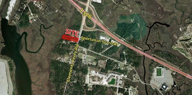
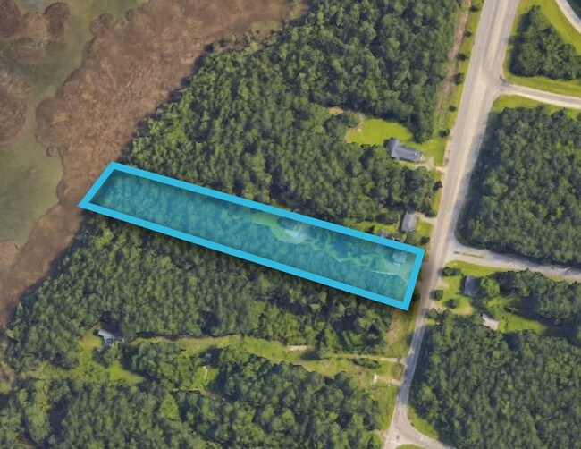
Property Record
2820 Clements Ferry Rd, Charleston, SC 29492


NEARBY LISTINGS FOR SALE OR LEASE
Property Detail
2820 Clements Ferry Rd
271-00-02-006
Commercial Around Hwy 526
Vacantlandnec
Berkeley
AE
South Carolina
45015C0720E
2.41 AC
2025
Daniel Island
2025
Charleston/N Charleston
020407
Charleston-North Charleston, SC
DEMOGRAPHICS near 2820 Clements Ferry Rd
1 Mile
3 Mile
5 Mile
2024 Total Population
718
28,092
76,878
2029 Population
834
32,637
86,067
Pop Growth 2024-2029
+ 16.16%
+ 16.18%
+ 11.95%
Average Age
38
40
39
2024 Total Households
301
12,054
31,745
HH Growth 2024-2029
+ 16.28%
+ 16.22%
+ 12.05%
Median Household Inc
$122,618
$83,261
$68,865
Avg Household Size
2.40
2.30
2.30
2024 Avg HH Vehicles
2.00
2.00
2.00
Median Home Value
$716,494
$649,213
$428,176
Median Year Built
2010
2006
1992
Nearby Places
Map Layers
Map Styles
 Street
 Aerial
- Restaurants
- Banks
- Shops
- Fitness
- Groceries
PUBLIC TRANSPORTATION
COMMUTER RAIL
Charleston Amtrak Station (Palmetto - Amtrak, Silver Meteor - Amtrak)
DRIVE
WALK
Distance
Charleston Amtrak Station (Palmetto - Amtrak, Silver Meteor - Amtrak)
10 min
6.4 mi
AIRPORT
Charleston AFB/International
DRIVE
WALK
Distance
Charleston AFB/International
18 min
11.9 mi
Freight Ports
Veterans Terminal
DRIVE
WALK
Distance
Veterans Terminal
16 min
10.8 mi
SALE & LEASE HISTORY
LISTING DATE
SALE/LEASE

Sep 24, 2016
For Sale
Mar 14, 2017
For Sale
Nearby Properties
Address
Land Use
TOTAL SIZE
Lot Size
Zoning
Address
Land Use
TOTAL SIZE
Lot Size
Zoning
56,268 SF
29.66 AC
BERKELEY C
Address
Land Use
TOTAL SIZE
Lot Size
Zoning
29,118 SF
7.83 AC
CHARLESTON
Address
Land Use
TOTAL SIZE
Lot Size
Zoning
372,400 SF
5.59 AC
CHARLESTON
Address
Land Use
TOTAL SIZE
Lot Size
Zoning
112,440 SF
16.15 AC
CHARLESTON
Address
Land Use
TOTAL SIZE
Lot Size
Zoning
28,677 SF
15.56 AC
BERKELEY C
Address
Land Use
TOTAL SIZE
Lot Size
Zoning
1,717 SF
40.95 AC
Address
Land Use
TOTAL SIZE
Lot Size
Zoning
62,366 SF
12.65 AC
CHARLESTON
Address
Land Use
TOTAL SIZE
Lot Size
Zoning
148,760 SF
6.91 AC
CHARLESTON
Address
Land Use
TOTAL SIZE
Lot Size
Zoning
14,402 SF
9.83 AC
CHARLESTON
Address
Land Use
TOTAL SIZE
Lot Size
Zoning
181,318 SF
4.87 AC
CHARLESTON
Address
Land Use
TOTAL SIZE
Lot Size
Zoning
267,280 SF
6.66 AC
CHARLESTON
Address
Land Use
TOTAL SIZE
Lot Size
Zoning
6,848 SF
43.53 AC
CHARLESTON
Address
Land Use
TOTAL SIZE
Lot Size
Zoning
96,576 SF
11.20 AC
CHARLESTON
Address
Land Use
TOTAL SIZE
Lot Size
Zoning
27,900 SF
102.67 AC
Address
Land Use
TOTAL SIZE
Lot Size
Zoning
224,766 SF
20.33 AC
CHARLESTON
Address
Land Use
TOTAL SIZE
Lot Size
Zoning
870 SF
14.87 AC
BERKELEY C
Address
Land Use
TOTAL SIZE
Lot Size
Zoning
168,570 SF
8.75 AC
CHARLESTON
Address
Land Use
TOTAL SIZE
Lot Size
Zoning
72,432 SF
4.08 AC
CHARLESTON
Address
Land Use
TOTAL SIZE
Lot Size
Zoning
75,596 SF
39.82 AC
CHARLESTON
Address
Land Use
TOTAL SIZE
Lot Size
Zoning
69,974 SF
2.66 AC
CHARLESTON
Address
Land Use
TOTAL SIZE
Lot Size
Zoning
91,112 SF
14.60 AC
CHARLESTON
Address
Land Use
TOTAL SIZE
Lot Size
Zoning
88,540 SF
3.32 AC
CHARLESTON
Address
Land Use
TOTAL SIZE
Lot Size
Zoning
480.58 AC
CHARLESTON
Address
Land Use
TOTAL SIZE
Lot Size
Zoning
21,291 SF
6.13 AC
CHARLESTON
Address
Land Use
TOTAL SIZE
Lot Size
Zoning
250,000 SF
28.97 AC
CHARLESTON
Address
Land Use
TOTAL SIZE
Lot Size
Zoning
65,776 SF
2.77 AC
CHARLESTON
Address
Land Use
TOTAL SIZE
Lot Size
Zoning
58,764 SF
25 AC
CHARLESTON
Address
Land Use
TOTAL SIZE
Lot Size
Zoning
75,005 SF
14.66 AC
CHARLESTON
Address
Land Use
TOTAL SIZE
Lot Size
Zoning
29,614 SF
4.08 AC
CHARLESTON
Address
Land Use
TOTAL SIZE
Lot Size
Zoning
203,200 SF
20.16 AC
BERKELEY C
The World's #1 Commercial Real Estate Marketplace
Connect with us
© 2025 CoStar Group
The information above has been obtained from sources believed reliable. While we do not doubt its accuracy we have not verified it and make no guarantee, warranty or representation about it. It is your responsibility to independently confirm its accuracy and completeness. Any projections, opinions, assumptions, or estimates used are for example only and do not represent the current or future performance of the property. The value of this transaction to you depends on tax and other factors which should be evaluated by your tax, financial, and legal advisors. You and your advisors should conduct a careful, independent investigation of the property to determine to your satisfaction the suitability of the property for your needs.