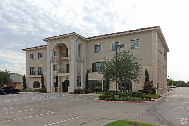
Property Record
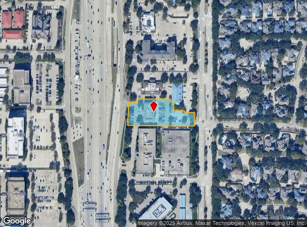
2820 Dallas Pky, Plano, TX 75093
NEARBY LISTINGS FOR SALE OR LEASE
Property Detail
2820 Dallas Pky
Dallas-Fort Worth-Arlington, TX
Parkway Hills Addition (Cpl)
R-2795-00A-0100-1
PARKWAY HILLS ADDITION, BLK A, LOT 10
Officebuilding
Collin
X
Texas
48085C0365L
10
2024
1.41 AC
2025
Upper Tollway/West Plano
031668
Dallas/Ft Worth
19,274 SF
DEMOGRAPHICS near 2820 Dallas Pky
1 Mile
3 Mile
5 Mile
2024 Total Population
11,357
128,543
369,469
2029 Population
13,719
155,812
442,409
Pop Growth 2024-2029
+ 20.80%
+ 21.21%
+ 19.74%
Average Age
41
39
39
2024 Total Households
4,342
60,784
159,912
HH Growth 2024-2029
+ 21.14%
+ 21.66%
+ 20.14%
Median Household Inc
$157,381
$86,625
$90,978
Avg Household Size
2.60
2.10
2.30
2024 Avg HH Vehicles
2.00
2.00
2.00
Median Home Value
$771,364
$532,699
$420,037
Median Year Built
1995
1994
1992
Nearby Places
Map Layers
Map Styles
 Street
 Aerial
- Restaurants
- Banks
- Shops
- Fitness
- Groceries
PUBLIC TRANSPORTATION
COMMUTER RAIL
Trinity Mills Station (Green Line - Dallas Area Rapid Transit (DART))
DRIVE
WALK
Distance
Trinity Mills Station (Green Line - Dallas Area Rapid Transit (DART))
15 min
9.7 mi
DRIVE
WALK
Distance
18 min
9.9 mi
AIRPORT
Dallas Love Field
DRIVE
WALK
Distance
Dallas Love Field
25 min
17.8 mi
Dallas-Fort Worth International
DRIVE
WALK
Distance
Dallas-Fort Worth International
29 min
22.3 mi
Nearby Properties
Address
Land Use
TOTAL SIZE
Lot Size
Zoning
Address
Land Use
TOTAL SIZE
Lot Size
Zoning
1,929,059 SF
55.12 AC
CE
Address
Land Use
TOTAL SIZE
Lot Size
Zoning
558,664 SF
20.14 AC
CE
Address
Land Use
TOTAL SIZE
Lot Size
Zoning
492,661 SF
4.89 AC
Address
Land Use
TOTAL SIZE
Lot Size
Zoning
725,987 SF
34.18 AC
CE
Address
Land Use
TOTAL SIZE
Lot Size
Zoning
542,570 SF
75.67 AC
Address
Land Use
TOTAL SIZE
Lot Size
Zoning
343,539 SF
34.74 AC
S-164
Address
Land Use
TOTAL SIZE
Lot Size
Zoning
719,177 SF
27.02 AC
O-2
Address
Land Use
TOTAL SIZE
Lot Size
Zoning
455,432 SF
2.55 AC
MULTI-FAMI
Address
Land Use
TOTAL SIZE
Lot Size
Zoning
356,196 SF
3.71 AC
CB-1
Address
Land Use
TOTAL SIZE
Lot Size
Zoning
526,509 SF
135.02 AC
Address
Land Use
TOTAL SIZE
Lot Size
Zoning
320,098 SF
20 AC
CE
Address
Land Use
TOTAL SIZE
Lot Size
Zoning
1,578,500 SF
91.04 AC
Address
Land Use
TOTAL SIZE
Lot Size
Zoning
518,210 SF
38.11 AC
CE
Address
Land Use
TOTAL SIZE
Lot Size
Zoning
401,260 SF
23.33 AC
CE
Address
Land Use
TOTAL SIZE
Lot Size
Zoning
374,300 SF
6.73 AC
CB-1
Address
Land Use
TOTAL SIZE
Lot Size
Zoning
615,249 SF
16.17 AC
COMM
Address
Land Use
TOTAL SIZE
Lot Size
Zoning
319,876 SF
3.36 AC
Address
Land Use
TOTAL SIZE
Lot Size
Zoning
275,457 SF
3.69 AC
CE
Address
Land Use
TOTAL SIZE
Lot Size
Zoning
481,366 SF
6.31 AC
LC
Address
Land Use
TOTAL SIZE
Lot Size
Zoning
341,917 SF
2.86 AC
CB-1
Address
Land Use
TOTAL SIZE
Lot Size
Zoning
337,350 SF
2.32 AC
Address
Land Use
TOTAL SIZE
Lot Size
Zoning
545,224 SF
42.80 AC
Address
Land Use
TOTAL SIZE
Lot Size
Zoning
537,274 SF
20.91 AC
Address
Land Use
TOTAL SIZE
Lot Size
Zoning
435,683 SF
18.25 AC
COMM
Address
Land Use
TOTAL SIZE
Lot Size
Zoning
554,780 SF
23.81 AC
Address
Land Use
TOTAL SIZE
Lot Size
Zoning
482,025 SF
11.73 AC
LC
Address
Land Use
TOTAL SIZE
Lot Size
Zoning
512,903 SF
18 AC
Address
Land Use
TOTAL SIZE
Lot Size
Zoning
500,844 SF
24.36 AC
2B
Address
Land Use
TOTAL SIZE
Lot Size
Zoning
156,000 SF
9 AC
CE
Address
Land Use
TOTAL SIZE
Lot Size
Zoning
296,434 SF
19.66 AC
CE
The World's #1 Commercial Real Estate Marketplace
Connect with us
© 2026 CoStar Group
The information above has been obtained from sources believed reliable. While we do not doubt its accuracy we have not verified it and make no guarantee, warranty or representation about it. It is your responsibility to independently confirm its accuracy and completeness. Any projections, opinions, assumptions, or estimates used are for example only and do not represent the current or future performance of the property. The value of this transaction to you depends on tax and other factors which should be evaluated by your tax, financial, and legal advisors. You and your advisors should conduct a careful, independent investigation of the property to determine to your satisfaction the suitability of the property for your needs.