Property Record
2820 Lillington Hwy, Spring Lake, NC 28390
NEARBY LISTINGS FOR SALE OR LEASE
-
-
View all Spring Lake listings for sale on LoopNet.com
Property Detail
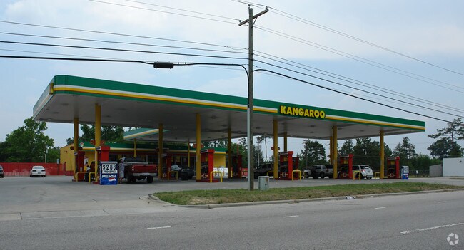
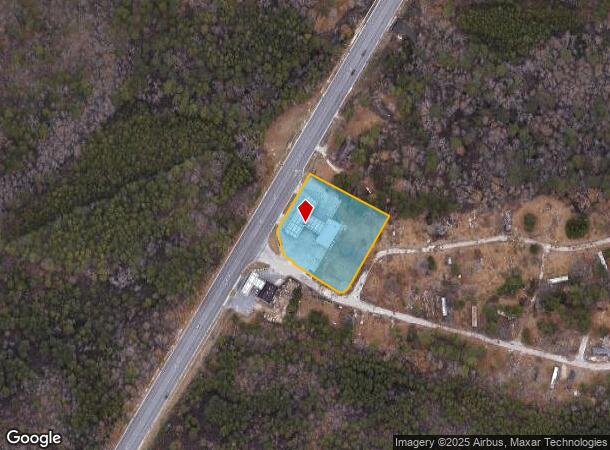
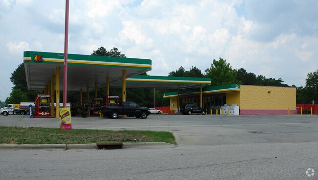
2820 Lillington Hwy
Fayetteville, NC
Spring Lake Area
0513-63-8443
J I LEWIS JR REV SE:01 PL:0094-0018
Conveniencestore
Cumberland
X
North Carolina
3720051300L
8443
2025
1.76 AC
2025
Spring Lake
003602
Fayetteville
3,200 SF
DEMOGRAPHICS near 2820 Lillington Hwy
1 Mile
3 Mile
5 Mile
2024 Total Population
1,258
12,829
36,268
2029 Population
1,320
13,783
37,990
Pop Growth 2024-2029
+ 4.93%
+ 7.44%
+ 4.75%
Average Age
36
34
33
2024 Total Households
467
4,828
13,223
HH Growth 2024-2029
+ 4.71%
+ 7.13%
+ 4.61%
Median Household Inc
$49,840
$55,291
$53,714
Avg Household Size
2.70
2.70
2.60
2024 Avg HH Vehicles
2.00
2.00
2.00
Median Home Value
$93,447
$152,820
$179,451
Median Year Built
1984
1997
1994
Nearby Places
Map Layers
Map Styles
 Street
 Aerial
- Restaurants
- Banks
- Shops
- Fitness
- Groceries
PUBLIC TRANSPORTATION
AIRPORT
Fayetteville Regional/Grannis Field
DRIVE
WALK
Distance
Fayetteville Regional/Grannis Field
30 min
18.8 mi
Freight Ports
Port of Wilmington
DRIVE
WALK
Distance
Port of Wilmington
147 min
104.5 mi
Nearby Properties
Address
Land Use
TOTAL SIZE
Lot Size
Zoning
Address
Land Use
TOTAL SIZE
Lot Size
Zoning
2,580 SF
27.55 AC
R5A
Address
Land Use
TOTAL SIZE
Lot Size
Zoning
2,600 SF
21.95 AC
R10
Address
Land Use
TOTAL SIZE
Lot Size
Zoning
2,400 SF
21.45 AC
R5A-RESIDE
Address
Land Use
TOTAL SIZE
Lot Size
Zoning
54.49 AC
RA20M
Address
Land Use
TOTAL SIZE
Lot Size
Zoning
30.82 AC
RA20M
Address
Land Use
TOTAL SIZE
Lot Size
Zoning
37.95 AC
RA20M
Address
Land Use
TOTAL SIZE
Lot Size
Zoning
4,192 SF
12.81 AC
R5A
Address
Land Use
TOTAL SIZE
Lot Size
Zoning
31,876 SF
7.38 AC
CP
Address
Land Use
TOTAL SIZE
Lot Size
Zoning
8,523 SF
10 AC
M1P
Address
Land Use
TOTAL SIZE
Lot Size
Zoning
21,800 SF
3.01 AC
M1PCU
Address
Land Use
TOTAL SIZE
Lot Size
Zoning
2,608 SF
2.26 AC
CP-PLANNED
Address
Land Use
TOTAL SIZE
Lot Size
Zoning
768 SF
84.77 AC
R15
Address
Land Use
TOTAL SIZE
Lot Size
Zoning
12,936 SF
28.30 AC
RR
Address
Land Use
TOTAL SIZE
Lot Size
Zoning
1,406 SF
251.41 AC
PND
Address
Land Use
TOTAL SIZE
Lot Size
Zoning
1,052 SF
3.33 AC
CPCZ-COM'L
Address
Land Use
TOTAL SIZE
Lot Size
Zoning
20,000 SF
13.53 AC
M1P
Address
Land Use
TOTAL SIZE
Lot Size
Zoning
2,000 SF
5.09 AC
COMM
Address
Land Use
TOTAL SIZE
Lot Size
Zoning
22,464 SF
17.65 AC
RA20R
Address
Land Use
TOTAL SIZE
Lot Size
Zoning
7,068 SF
5 AC
R10
Address
Land Use
TOTAL SIZE
Lot Size
Zoning
10,791 SF
976.70 AC
RR
Address
Land Use
TOTAL SIZE
Lot Size
Zoning
1,049 SF
4.74 AC
CP
Address
Land Use
TOTAL SIZE
Lot Size
Zoning
9,600 SF
9.10 AC
C1P
Address
Land Use
TOTAL SIZE
Lot Size
Zoning
1.81 AC
CP-PLANNED
Address
Land Use
TOTAL SIZE
Lot Size
Zoning
19,123 SF
10.40 AC
R10
Address
Land Use
TOTAL SIZE
Lot Size
Zoning
1.58 AC
C1P
Address
Land Use
TOTAL SIZE
Lot Size
Zoning
9,714 SF
5.90 AC
R10
Address
Land Use
TOTAL SIZE
Lot Size
Zoning
9,540 SF
1.05 AC
C3
Address
Land Use
TOTAL SIZE
Lot Size
Zoning
1,862 SF
2.73 AC
CP
Address
Land Use
TOTAL SIZE
Lot Size
Zoning
19.36 AC
R5A
Address
Land Use
TOTAL SIZE
Lot Size
Zoning
9,100 SF
2.09 AC
COMM
The World's #1 Commercial Real Estate Marketplace
Connect with us
© 2026 CoStar Group
The information above has been obtained from sources believed reliable. While we do not doubt its accuracy we have not verified it and make no guarantee, warranty or representation about it. It is your responsibility to independently confirm its accuracy and completeness. Any projections, opinions, assumptions, or estimates used are for example only and do not represent the current or future performance of the property. The value of this transaction to you depends on tax and other factors which should be evaluated by your tax, financial, and legal advisors. You and your advisors should conduct a careful, independent investigation of the property to determine to your satisfaction the suitability of the property for your needs.