Property Record
2820 Shipyard Ln, East Marion, NY 11939

NEARBY LISTINGS FOR SALE OR LEASE
-
-
View all East Marion listings for sale on LoopNet.com
Property Detail
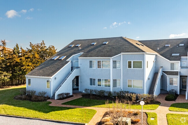
2820 Shipyard Ln
Nassau County-Suffolk County, NY
Cleaves Point Village Condominium
1000-038-02-01-00-041-000
UNIT #4Q4
Apartment
Suffolk
AE
New York
36103C0176H
44
2024
0.20 AC
2024
Outlying Eastern Suffolk
170206
Long Island (New York)
DEMOGRAPHICS near 2820 Shipyard Ln
1 Mile
3 Mile
5 Mile
2024 Total Population
2,206
9,934
13,195
2029 Population
2,339
10,261
13,537
Pop Growth 2024-2029
+ 6.03%
+ 3.29%
+ 2.59%
Average Age
48
48
48
2024 Total Households
964
4,308
5,752
HH Growth 2024-2029
+ 6.02%
+ 3.39%
+ 2.61%
Median Household Inc
$74,494
$80,758
$86,434
Avg Household Size
2.30
2.20
2.20
2024 Avg HH Vehicles
2.00
2.00
2.00
Median Home Value
$748,964
$771,401
$774,370
Median Year Built
1968
1970
1971
Nearby Places
- Restaurants
- Banks
- Shops
- Fitness
- Groceries
PUBLIC TRANSPORTATION
COMMUTER RAIL
Greenport Station (Greenport Branch - Long Island Rail Road)
DRIVE
WALK
Distance
Greenport Station (Greenport Branch - Long Island Rail Road)
8 min
3.1 mi
Southold Station (Greenport Branch - Long Island Rail Road)
DRIVE
WALK
Distance
Southold Station (Greenport Branch - Long Island Rail Road)
12 min
6.7 mi
Freight Ports
Port of New Haven
DRIVE
WALK
Distance
Port of New Haven
164 min
71.4 mi
Nearby Properties
Address
Land Use
TOTAL SIZE
Lot Size
Zoning
Address
Land Use
TOTAL SIZE
Lot Size
Zoning
8,705 SF
138.70 AC
AA
Address
Land Use
TOTAL SIZE
Lot Size
Zoning
2,076 SF
42.20 AC
AA
Address
Land Use
TOTAL SIZE
Lot Size
Zoning
12,000 SF
5.39 AC
B
Address
Land Use
TOTAL SIZE
Lot Size
Zoning
2.20 AC
AA
Address
Land Use
TOTAL SIZE
Lot Size
Zoning
6,131 SF
1.40 AC
B
Address
Land Use
TOTAL SIZE
Lot Size
Zoning
1,674 SF
10.56 AC
B
Address
Land Use
TOTAL SIZE
Lot Size
Zoning
11.70 AC
AA
Address
Land Use
TOTAL SIZE
Lot Size
Zoning
2,000 SF
0.54 AC
B
Address
Land Use
TOTAL SIZE
Lot Size
Zoning
57.20 AC
AA
Address
Land Use
TOTAL SIZE
Lot Size
Zoning
28.59 AC
AA
Address
Land Use
TOTAL SIZE
Lot Size
Zoning
7,022 SF
0.70 AC
C
Address
Land Use
TOTAL SIZE
Lot Size
Zoning
4,386 SF
1.62 AC
B
Address
Land Use
TOTAL SIZE
Lot Size
Zoning
9.63 AC
CAUSEWAY
Address
Land Use
TOTAL SIZE
Lot Size
Zoning
35.95 AC
C
Address
Land Use
TOTAL SIZE
Lot Size
Zoning
8.10 AC
A
Address
Land Use
TOTAL SIZE
Lot Size
Zoning
4.80 AC
A
Address
Land Use
TOTAL SIZE
Lot Size
Zoning
0.88 AC
AA
Address
Land Use
TOTAL SIZE
Lot Size
Zoning
10,000 SF
1.15 AC
B
Address
Land Use
TOTAL SIZE
Lot Size
Zoning
6.70 AC
AA
Address
Land Use
TOTAL SIZE
Lot Size
Zoning
2,278 SF
1.17 AC
B
Address
Land Use
TOTAL SIZE
Lot Size
Zoning
3,910 SF
0.30 AC
B
Address
Land Use
TOTAL SIZE
Lot Size
Zoning
6.80 AC
AA
Address
Land Use
TOTAL SIZE
Lot Size
Zoning
2,143 SF
1.66 AC
C
Address
Land Use
TOTAL SIZE
Lot Size
Zoning
3,136 SF
5.70 AC
AA
Address
Land Use
TOTAL SIZE
Lot Size
Zoning
3,709 SF
0.15 AC
B
Address
Land Use
TOTAL SIZE
Lot Size
Zoning
3,140 SF
0.62 AC
B
Address
Land Use
TOTAL SIZE
Lot Size
Zoning
4,402 SF
0.25 AC
R4
Address
Land Use
TOTAL SIZE
Lot Size
Zoning
3,579 SF
0.10 AC
B
Address
Land Use
TOTAL SIZE
Lot Size
Zoning
4,367 SF
0.50 AC
B1
Address
Land Use
TOTAL SIZE
Lot Size
Zoning
2,292 SF
0.25 AC
AA
The World's #1 Commercial Real Estate Marketplace
Connect with us
© 2025 CoStar Group
The information above has been obtained from sources believed reliable. While we do not doubt its accuracy we have not verified it and make no guarantee, warranty or representation about it. It is your responsibility to independently confirm its accuracy and completeness. Any projections, opinions, assumptions, or estimates used are for example only and do not represent the current or future performance of the property. The value of this transaction to you depends on tax and other factors which should be evaluated by your tax, financial, and legal advisors. You and your advisors should conduct a careful, independent investigation of the property to determine to your satisfaction the suitability of the property for your needs.