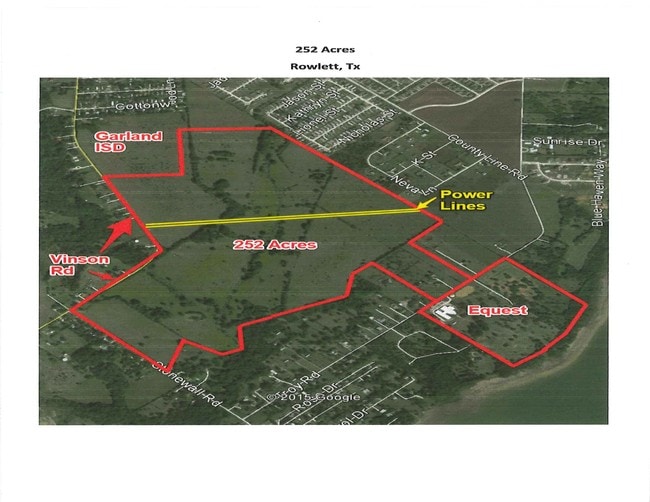
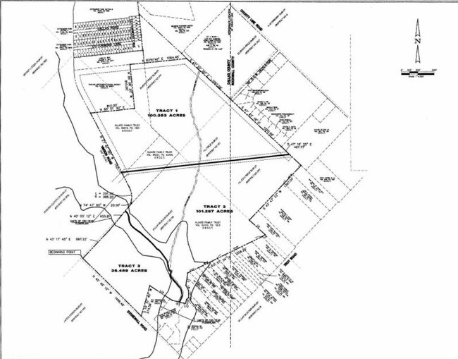
Property Record
2820 Vinson Rd, Wylie, TX 75098
NEARBY LISTINGS FOR SALE OR LEASE
Property Detail
2820 Vinson Rd
Dallas-Fort Worth-Arlington, TX
Elisha M Price
65111431510110100
ELISHA M PRICE ABST 1114 PG 315 TR 11 ACS 8.315 INT202200229408 DD08112022 CO-DC 1114315101100 2NT11143151
Commercialacreage
Dallas
X
Texas
48113C0235K
88.77 AC
2024
Garland
2025
Dallas/Ft Worth
031319
DEMOGRAPHICS near 2820 Vinson Rd
1 Mile
3 Mile
5 Mile
2024 Total Population
4,433
48,363
149,694
2029 Population
5,173
56,327
176,055
Pop Growth 2024-2029
+ 16.69%
+ 16.47%
+ 17.61%
Average Age
36
37
38
2024 Total Households
1,340
15,358
48,581
HH Growth 2024-2029
+ 16.12%
+ 16.52%
+ 17.90%
Median Household Inc
$111,153
$117,291
$112,140
Avg Household Size
3.30
3.10
3.00
2024 Avg HH Vehicles
3.00
2.00
2.00
Median Home Value
$343,349
$337,997
$306,834
Median Year Built
2004
2003
2003
Nearby Places
Map Layers
Map Styles
 Street
 Aerial
- Restaurants
- Banks
- Shops
- Fitness
- Groceries
PUBLIC TRANSPORTATION
AIRPORT
Dallas Love Field
DRIVE
WALK
Distance
Dallas Love Field
49 min
32.6 mi
Freight Ports
Port of Shreveport
DRIVE
WALK
Distance
Port of Shreveport
226 min
194.2 mi
Nearby Properties
Address
Land Use
TOTAL SIZE
Lot Size
Zoning
Address
Land Use
TOTAL SIZE
Lot Size
Zoning
266,957 SF
11.34 AC
MFR
Address
Land Use
TOTAL SIZE
Lot Size
Zoning
393,054 SF
55.95 AC
Address
Land Use
TOTAL SIZE
Lot Size
Zoning
228,536 SF
10.54 AC
MF-M
Address
Land Use
TOTAL SIZE
Lot Size
Zoning
132,306 SF
7.85 AC
MF
Address
Land Use
TOTAL SIZE
Lot Size
Zoning
83,296 SF
14.88 AC
Z01
Address
Land Use
TOTAL SIZE
Lot Size
Zoning
97,898 SF
10.82 AC
Address
Land Use
TOTAL SIZE
Lot Size
Zoning
79,346 SF
10.42 AC
Address
Land Use
TOTAL SIZE
Lot Size
Zoning
125,000 SF
22.42 AC
FLOOD
Address
Land Use
TOTAL SIZE
Lot Size
Zoning
91,585 SF
4.33 AC
I
Address
Land Use
TOTAL SIZE
Lot Size
Zoning
109 SF
17.90 AC
Z268
Address
Land Use
TOTAL SIZE
Lot Size
Zoning
227.41 AC
PD3
Address
Land Use
TOTAL SIZE
Lot Size
Zoning
54,240 SF
2.12 AC
MF
Address
Land Use
TOTAL SIZE
Lot Size
Zoning
3,027 SF
108.32 AC
SUP
Address
Land Use
TOTAL SIZE
Lot Size
Zoning
94,981 SF
11.55 AC
Address
Land Use
TOTAL SIZE
Lot Size
Zoning
1,600 SF
16.22 AC
PD
Address
Land Use
TOTAL SIZE
Lot Size
Zoning
40,762 SF
4.70 AC
CR
Address
Land Use
TOTAL SIZE
Lot Size
Zoning
19,026 SF
77.70 AC
Z236
Address
Land Use
TOTAL SIZE
Lot Size
Zoning
108,582 SF
10 AC
Address
Land Use
TOTAL SIZE
Lot Size
Zoning
62,487 SF
7.25 AC
CR
Address
Land Use
TOTAL SIZE
Lot Size
Zoning
88,452 SF
7.96 AC
Address
Land Use
TOTAL SIZE
Lot Size
Zoning
42,665 SF
3.21 AC
Address
Land Use
TOTAL SIZE
Lot Size
Zoning
172 SF
31.22 AC
Address
Land Use
TOTAL SIZE
Lot Size
Zoning
112 SF
18.61 AC
Z268
Address
Land Use
TOTAL SIZE
Lot Size
Zoning
133,383 SF
8.56 AC
I
Address
Land Use
TOTAL SIZE
Lot Size
Zoning
15,972 SF
1.96 AC
Address
Land Use
TOTAL SIZE
Lot Size
Zoning
17,525 SF
3.56 AC
Address
Land Use
TOTAL SIZE
Lot Size
Zoning
61 SF
8.07 AC
R
Address
Land Use
TOTAL SIZE
Lot Size
Zoning
59,836 SF
3.87 AC
Address
Land Use
TOTAL SIZE
Lot Size
Zoning
59,150 SF
5.13 AC
Address
Land Use
TOTAL SIZE
Lot Size
Zoning
113,863 SF
5.53 AC
Z31
The World's #1 Commercial Real Estate Marketplace
Connect with us
© 2026 CoStar Group
The information above has been obtained from sources believed reliable. While we do not doubt its accuracy we have not verified it and make no guarantee, warranty or representation about it. It is your responsibility to independently confirm its accuracy and completeness. Any projections, opinions, assumptions, or estimates used are for example only and do not represent the current or future performance of the property. The value of this transaction to you depends on tax and other factors which should be evaluated by your tax, financial, and legal advisors. You and your advisors should conduct a careful, independent investigation of the property to determine to your satisfaction the suitability of the property for your needs.