Property Record
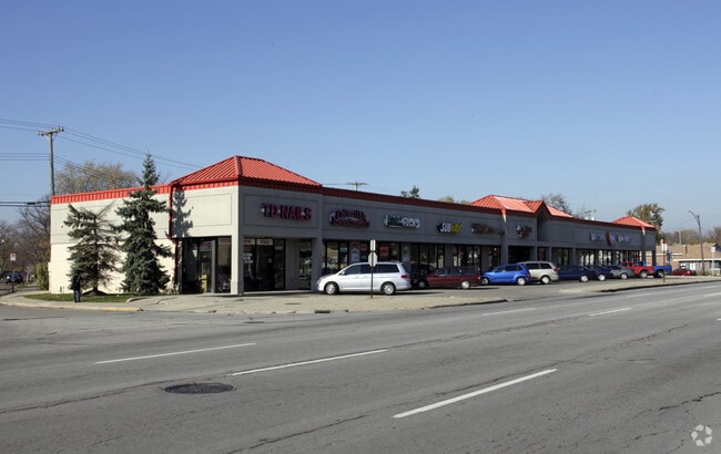
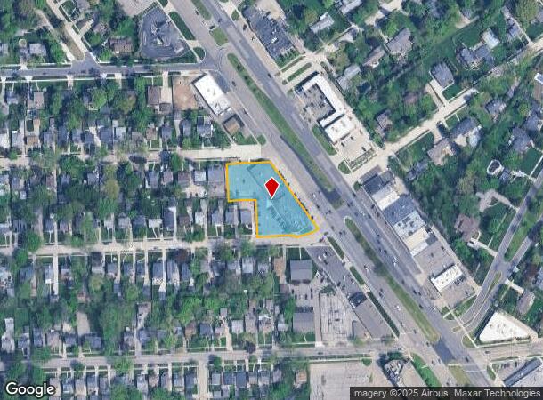
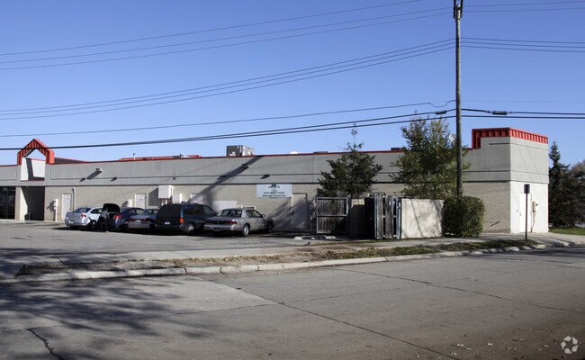
28201 Woodward Ave, Berkley, MI 48072
NEARBY LISTINGS FOR SALE OR LEASE
Property Detail
28201 Woodward Ave
Detroit-Warren-Dearborn, MI
Vinsetta Park Sub
25-17-258-045
T1N, R11E, SEC 17 VINSETTA PARK SUB LOTS 367 TO 378 INCL EXC NELY 44 FT OF EACH TAKEN FOR WOODWARD AVE, ALSO THAT PART OF ADJ FRANKLIN AVE DESC AS BEG AT PT DIST S 55-10-00 W 44 FT FROM MOST NLY COR OF LOT 367 TH S 55-10-00 W 56 FT, TH N 34-50-00 W 6
Regionalshoppingcenterormallwithanchorstore
Oakland
X
Michigan
26163C0100E
367
2024
0.96 AC
2024
Royal Oak
170000
Detroit
14,026 SF
DEMOGRAPHICS near 28201 Woodward Ave
1 Mile
3 Mile
5 Mile
2024 Total Population
16,141
141,316
330,386
2029 Population
15,934
139,907
326,585
Pop Growth 2024-2029
(1.28%)
(1.00%)
(1.15%)
Average Age
41
41
41
2024 Total Households
7,232
65,848
148,404
HH Growth 2024-2029
(1.23%)
(0.95%)
(1.11%)
Median Household Inc
$106,250
$85,846
$75,803
Avg Household Size
2.20
2.10
2.20
2024 Avg HH Vehicles
2.00
2.00
2.00
Median Home Value
$312,844
$259,629
$231,646
Median Year Built
1950
1955
1957
Nearby Places
Map Layers
Map Styles
 Street
 Aerial
- Restaurants
- Banks
- Shops
- Fitness
- Groceries
PUBLIC TRANSPORTATION
COMMUTER RAIL
Royal Oak Amtrak (Wolverine - Amtrak)
DRIVE
WALK
Distance
Royal Oak Amtrak (Wolverine - Amtrak)
4 min
1.6 mi
Troy Amtrak Station (Wolverine - Amtrak)
DRIVE
WALK
Distance
Troy Amtrak Station (Wolverine - Amtrak)
9 min
4.1 mi
AIRPORT
Windsor International
DRIVE
WALK
Distance
Windsor International
43 min
24.3 mi
Detroit Metro Wayne County
DRIVE
WALK
Distance
Detroit Metro Wayne County
48 min
33.9 mi
Freight Ports
Port of Toledo
DRIVE
WALK
Distance
Port of Toledo
93 min
74.9 mi
SALE & LEASE HISTORY
LISTING DATE
SALE/LEASE

Nov 27, 2018
For Lease
Nov 26, 2018
For Lease
Nearby Properties
Address
Land Use
TOTAL SIZE
Lot Size
Zoning
Address
Land Use
TOTAL SIZE
Lot Size
Zoning
4.20 AC
REG BUS
Address
Land Use
TOTAL SIZE
Lot Size
Zoning
0.81 AC
CBD
Address
Land Use
TOTAL SIZE
Lot Size
Zoning
10,734 SF
3.52 AC
SPEC REDEV
Address
Land Use
TOTAL SIZE
Lot Size
Zoning
187,801 SF
5.49 AC
RM-2
Address
Land Use
TOTAL SIZE
Lot Size
Zoning
15.32 AC
GEN BUS
Address
Land Use
TOTAL SIZE
Lot Size
Zoning
72,457 SF
5.60 AC
OFFICE SVC
Address
Land Use
TOTAL SIZE
Lot Size
Zoning
804 SF
1.50 AC
CBD
Address
Land Use
TOTAL SIZE
Lot Size
Zoning
1.46 AC
CBD
Address
Land Use
TOTAL SIZE
Lot Size
Zoning
339,780 SF
22.29 AC
RM-1
Address
Land Use
TOTAL SIZE
Lot Size
Zoning
24.30 AC
GEN BUS
Address
Land Use
TOTAL SIZE
Lot Size
Zoning
212 SF
16.59 AC
RM
Address
Land Use
TOTAL SIZE
Lot Size
Zoning
417,880 SF
6.76 AC
RM-2
Address
Land Use
TOTAL SIZE
Lot Size
Zoning
171,259 SF
1.26 AC
CBD
Address
Land Use
TOTAL SIZE
Lot Size
Zoning
290,448 SF
9.01 AC
O
Address
Land Use
TOTAL SIZE
Lot Size
Zoning
62,528 SF
5.27 AC
M-1 LT
Address
Land Use
TOTAL SIZE
Lot Size
Zoning
13.89 AC
PUD
Address
Land Use
TOTAL SIZE
Lot Size
Zoning
128,309 SF
1.74 AC
Address
Land Use
TOTAL SIZE
Lot Size
Zoning
0.61 AC
CBD
Address
Land Use
TOTAL SIZE
Lot Size
Zoning
1.07 AC
MIX USE 2
Address
Land Use
TOTAL SIZE
Lot Size
Zoning
46,894 SF
0.52 AC
CBD
Address
Land Use
TOTAL SIZE
Lot Size
Zoning
168,560 SF
13.75 AC
RS
Address
Land Use
TOTAL SIZE
Lot Size
Zoning
43,437 SF
3.30 AC
REG BUS
Address
Land Use
TOTAL SIZE
Lot Size
Zoning
290,448 SF
8.92 AC
O
Address
Land Use
TOTAL SIZE
Lot Size
Zoning
212,847 SF
11.07 AC
GEN IND
Address
Land Use
TOTAL SIZE
Lot Size
Zoning
147,186 SF
3.20 AC
AI
Address
Land Use
TOTAL SIZE
Lot Size
Zoning
73,701 SF
1.61 AC
PUD
Address
Land Use
TOTAL SIZE
Lot Size
Zoning
512 SF
1.18 AC
GEN BUS
Address
Land Use
TOTAL SIZE
Lot Size
Zoning
44,396 SF
7.86 AC
MULT FAM
Address
Land Use
TOTAL SIZE
Lot Size
Zoning
Address
Land Use
TOTAL SIZE
Lot Size
Zoning
31,784 SF
7.26 AC
MULT FAM
The World's #1 Commercial Real Estate Marketplace
Connect with us
© 2025 CoStar Group
The information above has been obtained from sources believed reliable. While we do not doubt its accuracy we have not verified it and make no guarantee, warranty or representation about it. It is your responsibility to independently confirm its accuracy and completeness. Any projections, opinions, assumptions, or estimates used are for example only and do not represent the current or future performance of the property. The value of this transaction to you depends on tax and other factors which should be evaluated by your tax, financial, and legal advisors. You and your advisors should conduct a careful, independent investigation of the property to determine to your satisfaction the suitability of the property for your needs.