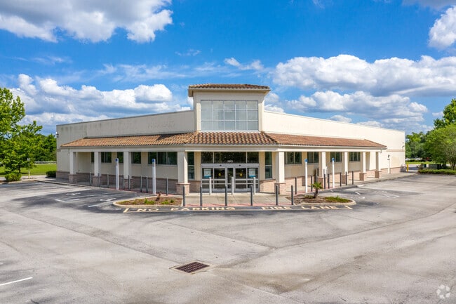
Property Record
2821 W 25Th St, Sanford, FL 32771


Current Lease Availabilities
NEARBY LISTINGS FOR SALE OR LEASE
-
-
-
-
-
-
-
-
-
-
-
-
-
-
-
-
-
-
-
-
-
-
No Photo
-
-
View all Sanford listings for lease on LoopNet.com
Property Detail
2821 W 25Th St
Orlando-Kissimmee-Sanford, FL
Greenway Shoppes
03-20-30-526-0000-0020
LOT 2 GREENWAY SHOPPES PB 68 PG 53
Storemultistory
Seminole
X
Florida
12069C0450E
2
2025
1.75 AC
2025
Lake Mary
020806
Orlando
14,362 SF
DEMOGRAPHICS near 2821 W 25Th St
1 Mile
3 Mile
5 Mile
2024 Total Population
8,588
78,049
140,022
2029 Population
8,929
81,823
146,609
Pop Growth 2024-2029
+ 3.97%
+ 4.84%
+ 4.70%
Average Age
39
39
40
2024 Total Households
3,236
30,197
53,692
HH Growth 2024-2029
+ 4.08%
+ 4.97%
+ 4.83%
Median Household Inc
$73,206
$59,338
$69,454
Avg Household Size
2.60
2.50
2.50
2024 Avg HH Vehicles
2.00
2.00
2.00
Median Home Value
$279,385
$263,118
$308,694
Median Year Built
1990
1992
1994
Nearby Places
Map Layers
Map Styles
 Street
 Aerial
- Restaurants
- Banks
- Shops
- Fitness
- Groceries
PUBLIC TRANSPORTATION
COMMUTER RAIL
Sanford Amtrak Auto Train Station (Auto Train - Amtrak)
DRIVE
WALK
Distance
Sanford Amtrak Auto Train Station (Auto Train - Amtrak)
6 min
2.3 mi
Sanford (SunRail - Florida Department of Transportation)
DRIVE
WALK
Distance
Sanford (SunRail - Florida Department of Transportation)
7 min
3.5 mi
AIRPORT
Orlando Sanford International
DRIVE
WALK
Distance
Orlando Sanford International
11 min
6.2 mi
Orlando International
DRIVE
WALK
Distance
Orlando International
40 min
33.1 mi
Freight Ports
Port Canaveral
DRIVE
WALK
Distance
Port Canaveral
77 min
66.1 mi
Nearby Properties
Address
Land Use
TOTAL SIZE
Lot Size
Zoning
Address
Land Use
TOTAL SIZE
Lot Size
Zoning
381,015 SF
24.76 AC
Address
Land Use
TOTAL SIZE
Lot Size
Zoning
1,225 SF
17 AC
Address
Land Use
TOTAL SIZE
Lot Size
Zoning
1,992 SF
4.76 AC
A1
Address
Land Use
TOTAL SIZE
Lot Size
Zoning
918,847 SF
190.82 AC
MR2
Address
Land Use
TOTAL SIZE
Lot Size
Zoning
11.65 AC
Address
Land Use
TOTAL SIZE
Lot Size
Zoning
36.94 AC
A1
Address
Land Use
TOTAL SIZE
Lot Size
Zoning
18,728 SF
22.36 AC
Address
Land Use
TOTAL SIZE
Lot Size
Zoning
2,181 SF
4.92 AC
A1
Address
Land Use
TOTAL SIZE
Lot Size
Zoning
425,407 SF
19.88 AC
Address
Land Use
TOTAL SIZE
Lot Size
Zoning
600 SF
20.98 AC
PD
Address
Land Use
TOTAL SIZE
Lot Size
Zoning
312 SF
10.47 AC
Address
Land Use
TOTAL SIZE
Lot Size
Zoning
0.93 AC
A1
Address
Land Use
TOTAL SIZE
Lot Size
Zoning
92,995 SF
31.61 AC
PUD
Address
Land Use
TOTAL SIZE
Lot Size
Zoning
23,184 SF
31.05 AC
PUD
Address
Land Use
TOTAL SIZE
Lot Size
Zoning
314,822 SF
10.96 AC
GC2
Address
Land Use
TOTAL SIZE
Lot Size
Zoning
24,382 SF
18.45 AC
A1
Address
Land Use
TOTAL SIZE
Lot Size
Zoning
311,881 SF
10.52 AC
PCD
Address
Land Use
TOTAL SIZE
Lot Size
Zoning
250 SF
14.29 AC
RMOI
Address
Land Use
TOTAL SIZE
Lot Size
Zoning
365,546 SF
50.24 AC
M1A
Address
Land Use
TOTAL SIZE
Lot Size
Zoning
269,490 SF
24.57 AC
PD
Address
Land Use
TOTAL SIZE
Lot Size
Zoning
504,437 SF
20.84 AC
A1
Address
Land Use
TOTAL SIZE
Lot Size
Zoning
3,668 SF
2.97 AC
C1
Address
Land Use
TOTAL SIZE
Lot Size
Zoning
1,001 SF
12.02 AC
MR3
Address
Land Use
TOTAL SIZE
Lot Size
Zoning
505 SF
1.94 AC
Address
Land Use
TOTAL SIZE
Lot Size
Zoning
10,757 SF
70.59 AC
C2
Address
Land Use
TOTAL SIZE
Lot Size
Zoning
938 SF
9.46 AC
SC3
Address
Land Use
TOTAL SIZE
Lot Size
Zoning
245,806 SF
24.93 AC
RMOI
Address
Land Use
TOTAL SIZE
Lot Size
Zoning
140,141 SF
6.73 AC
Address
Land Use
TOTAL SIZE
Lot Size
Zoning
864 SF
9.99 AC
A1
Address
Land Use
TOTAL SIZE
Lot Size
Zoning
209,424 SF
12.93 AC
MR2
The World's #1 Commercial Real Estate Marketplace
Connect with us
© 2025 CoStar Group
The information above has been obtained from sources believed reliable. While we do not doubt its accuracy we have not verified it and make no guarantee, warranty or representation about it. It is your responsibility to independently confirm its accuracy and completeness. Any projections, opinions, assumptions, or estimates used are for example only and do not represent the current or future performance of the property. The value of this transaction to you depends on tax and other factors which should be evaluated by your tax, financial, and legal advisors. You and your advisors should conduct a careful, independent investigation of the property to determine to your satisfaction the suitability of the property for your needs.