Property Record
2822 Central St, Evanston, IL 60201
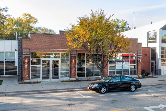

Property Detail
2822 Central St
10-11-202-032-1002
Cook
Commercialcondominium
Illinois
B and X Area of moderate flood hazard, usually the area between the limits of the 100-year and 500-year floods.
0.20 AC
2023
Near North
2025
Chicago
809000
Chicago-Naperville-Elgin, IL-IN
1,886 SF
NEARBY LISTINGS FOR SALE OR LEASE
DEMOGRAPHICS near 2822 Central St
1 mile
3 mile
5 mile
2025 Total Population
22,764
159,570
375,316
2030 Population
22,980
161,195
378,426
Pop Growth 2025-2030
+ 0.95%
+ 1.02%
+ 0.83%
Average Age
44
41
41
2025 Total Households
8,382
58,568
140,369
HH Growth 2025-2030
+ 0.75%
+ 0.92%
+ 0.68%
Median Household Inc
$168,501
$111,230
$93,357
Avg Household Size
2.60
2.50
2.50
2025 Avg HH Vehicles
2.00
2.00
1.00
Median Home Value
$705,777
$497,112
$449,151
Median Year Built
1949
1955
1954
Nearby Places
Map Layers
Map Styles
 Street
 Aerial
Layers
 Traffic
 Biking
Places
Listings with unknown addresses are not visible on the map
- Restaurants
- Banks
- Shops
- Fitness
- Groceries
PUBLIC TRANSPORTATION
TRANSIT/SUBWAY
Evanston Central Street Station (Union Pacific North Line - Northeast Illinois Regional Commuter Railroad (Metra))
Drive
Walk
Distance
Evanston Central Street Station (Union Pacific North Line - Northeast Illinois Regional Commuter Railroad (Metra))
2 min
16 min
0.8 mi
COMMUTER RAIL
Evanston Central Street Station (Union Pacific North Line - Northeast Illinois Regional Commuter Railroad (Metra))
Drive
Walk
Distance
Evanston Central Street Station (Union Pacific North Line - Northeast Illinois Regional Commuter Railroad (Metra))
2 min
16 min
0.8 mi
Wilmette Station (Union Pacific North Line - Northeast Illinois Regional Commuter Railroad (Metra))
Drive
Walk
Distance
Wilmette Station (Union Pacific North Line - Northeast Illinois Regional Commuter Railroad (Metra))
5 min
1.3 mi
AIRPORT
Chicago O'Hare International
Drive
Walk
Distance
Chicago O'Hare International
26 min
13.7 mi
Chicago Midway International
Drive
Walk
Distance
Chicago Midway International
39 min
22.6 mi
SALE & LEASE HISTORY
LISTING DATE
SALE/LEASE

May 25, 2023
For Lease
Jan 31, 2022
For Sale
Nearby Properties
Address
Land Use
TOTAL SIZE
Lot Size
Zoning
Address
Land Use
TOTAL SIZE
Lot Size
Zoning
999,808 SF
50.13 AC
Address
Land Use
TOTAL SIZE
Lot Size
Zoning
180,397 SF
0.78 AC
Address
Land Use
TOTAL SIZE
Lot Size
Zoning
0.63 AC
Address
Land Use
TOTAL SIZE
Lot Size
Zoning
341,698 SF
0.64 AC
Address
Land Use
TOTAL SIZE
Lot Size
Zoning
4,748 SF
0.40 AC
Address
Land Use
TOTAL SIZE
Lot Size
Zoning
303,960 SF
0.98 AC
Address
Land Use
TOTAL SIZE
Lot Size
Zoning
165,067 SF
10.88 AC
Address
Land Use
TOTAL SIZE
Lot Size
Zoning
0.84 AC
Address
Land Use
TOTAL SIZE
Lot Size
Zoning
415,554 SF
7.51 AC
Address
Land Use
TOTAL SIZE
Lot Size
Zoning
251,409 SF
16.33 AC
Address
Land Use
TOTAL SIZE
Lot Size
Zoning
232,552 SF
5.78 AC
Address
Land Use
TOTAL SIZE
Lot Size
Zoning
176,115 SF
1.04 AC
Address
Land Use
TOTAL SIZE
Lot Size
Zoning
172,538 SF
5.60 AC
Address
Land Use
TOTAL SIZE
Lot Size
Zoning
429,949 SF
16.06 AC
Address
Land Use
TOTAL SIZE
Lot Size
Zoning
10.58 AC
Address
Land Use
TOTAL SIZE
Lot Size
Zoning
218,982 SF
1.97 AC
Address
Land Use
TOTAL SIZE
Lot Size
Zoning
243,781 SF
0.84 AC
Address
Land Use
TOTAL SIZE
Lot Size
Zoning
110,528 SF
3.05 AC
Address
Land Use
TOTAL SIZE
Lot Size
Zoning
6.90 AC
Address
Land Use
TOTAL SIZE
Lot Size
Zoning
0.84 AC
Address
Land Use
TOTAL SIZE
Lot Size
Zoning
Address
Land Use
TOTAL SIZE
Lot Size
Zoning
163,981 SF
4 AC
Address
Land Use
TOTAL SIZE
Lot Size
Zoning
145,548 SF
0.80 AC
Address
Land Use
TOTAL SIZE
Lot Size
Zoning
8,550 SF
0.25 AC
Address
Land Use
TOTAL SIZE
Lot Size
Zoning
121,642 SF
1.65 AC
Address
Land Use
TOTAL SIZE
Lot Size
Zoning
372,244 SF
7.12 AC
Address
Land Use
TOTAL SIZE
Lot Size
Zoning
1.67 AC
Address
Land Use
TOTAL SIZE
Lot Size
Zoning
2.46 AC
Address
Land Use
TOTAL SIZE
Lot Size
Zoning
208,785 SF
0.61 AC
Address
Land Use
TOTAL SIZE
Lot Size
Zoning
5.65 AC
The World's #1 Commercial Real Estate Marketplace
Connect with us
© 2026 CoStar Group
The information above has been obtained from sources believed reliable. While we do not doubt its accuracy we have not verified it and make no guarantee, warranty or representation about it. It is your responsibility to independently confirm its accuracy and completeness. Any projections, opinions, assumptions, or estimates used are for example only and do not represent the current or future performance of the property. The value of this transaction to you depends on tax and other factors which should be evaluated by your tax, financial, and legal advisors. You and your advisors should conduct a careful, independent investigation of the property to determine to your satisfaction the suitability of the property for your needs.