Property Record
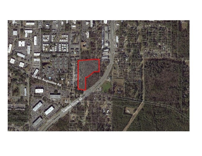
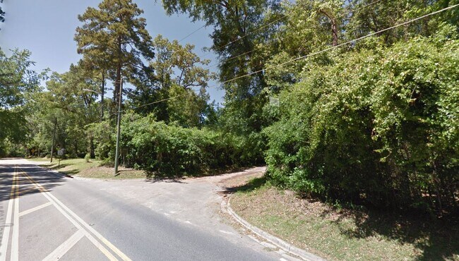
2822 Old Saint Augustine Rd, Tallahassee, FL 32301

NEARBY LISTINGS FOR SALE OR LEASE
Property Detail
2822 Old Saint Augustine Rd
31-04-20-405-000.0
Unplatted Land
Multifamilydwelling
4 1S 1E IN W 1/2 OF SE 1/4 OF SE 1/4 TRACT 1 OF A TA OR 711/236(LESS ROW- OR 4330/1358) 5241/1180(TA)
A
Leon
12073C0311F
Florida
2025
8.82 AC
2025
East Tallahassee
000905
Tallahassee
26,358 SF
Tallahassee, FL
DEMOGRAPHICS near 2822 Old Saint Augustine Rd
1 Mile
3 Mile
5 Mile
2024 Total Population
9,984
49,292
124,260
2029 Population
10,770
52,398
131,173
Pop Growth 2024-2029
+ 7.87%
+ 6.30%
+ 5.56%
Average Age
34
37
36
2024 Total Households
4,587
22,885
53,882
HH Growth 2024-2029
+ 7.87%
+ 6.55%
+ 5.92%
Median Household Inc
$55,594
$60,566
$53,671
Avg Household Size
2.10
2.10
2.10
2024 Avg HH Vehicles
1.00
2.00
2.00
Median Home Value
$177,662
$220,208
$238,700
Median Year Built
1992
1989
1985
Nearby Places
Map Layers
Map Styles
 Street
 Aerial
- Restaurants
- Banks
- Shops
- Fitness
- Groceries
PUBLIC TRANSPORTATION
AIRPORT
Tallahassee International
DRIVE
WALK
Distance
Tallahassee International
18 min
9.0 mi
SALE & LEASE HISTORY
LISTING DATE
SALE/LEASE

Sep 23, 2020
For Sale
Nearby Properties
Address
Land Use
TOTAL SIZE
Lot Size
Zoning
Address
Land Use
TOTAL SIZE
Lot Size
Zoning
2,322,139 SF
194.32 AC
PUD
Address
Land Use
TOTAL SIZE
Lot Size
Zoning
718,575 SF
47.84 AC
PUD
Address
Land Use
TOTAL SIZE
Lot Size
Zoning
602,388 SF
34.48 AC
Address
Land Use
TOTAL SIZE
Lot Size
Zoning
577,345 SF
30.63 AC
Address
Land Use
TOTAL SIZE
Lot Size
Zoning
846,072 SF
166.39 AC
R1
Address
Land Use
TOTAL SIZE
Lot Size
Zoning
200,705 SF
31.57 AC
Address
Land Use
TOTAL SIZE
Lot Size
Zoning
756,595 SF
18.35 AC
Address
Land Use
TOTAL SIZE
Lot Size
Zoning
756,294 SF
20.19 AC
OR3
Address
Land Use
TOTAL SIZE
Lot Size
Zoning
494,919 SF
20.12 AC
R4
Address
Land Use
TOTAL SIZE
Lot Size
Zoning
456,149 SF
22.50 AC
OR3
Address
Land Use
TOTAL SIZE
Lot Size
Zoning
367,539 SF
26.23 AC
CPA
Address
Land Use
TOTAL SIZE
Lot Size
Zoning
708,504 SF
50.44 AC
PUD
Address
Land Use
TOTAL SIZE
Lot Size
Zoning
380,000 SF
21.78 AC
PUD
Address
Land Use
TOTAL SIZE
Lot Size
Zoning
399,048 SF
19.43 AC
PUD
Address
Land Use
TOTAL SIZE
Lot Size
Zoning
376,746 SF
12.92 AC
OR2
Address
Land Use
TOTAL SIZE
Lot Size
Zoning
473,339 SF
51.93 AC
PUD
Address
Land Use
TOTAL SIZE
Lot Size
Zoning
276,623 SF
20.31 AC
CCPD
Address
Land Use
TOTAL SIZE
Lot Size
Zoning
636,937 SF
20.54 AC
Address
Land Use
TOTAL SIZE
Lot Size
Zoning
737,861 SF
24.79 AC
OR2
Address
Land Use
TOTAL SIZE
Lot Size
Zoning
410,469 SF
50.04 AC
PUD
Address
Land Use
TOTAL SIZE
Lot Size
Zoning
97,373 SF
16.38 AC
PUD
Address
Land Use
TOTAL SIZE
Lot Size
Zoning
399,815 SF
18.65 AC
Address
Land Use
TOTAL SIZE
Lot Size
Zoning
619,964 SF
6.47 AC
OR3
Address
Land Use
TOTAL SIZE
Lot Size
Zoning
338,619 SF
107.89 AC
GO1
Address
Land Use
TOTAL SIZE
Lot Size
Zoning
312,935 SF
11.74 AC
MR1
Address
Land Use
TOTAL SIZE
Lot Size
Zoning
312,935 SF
12.82 AC
MR1
Address
Land Use
TOTAL SIZE
Lot Size
Zoning
456,212 SF
117.40 AC
MR1
Address
Land Use
TOTAL SIZE
Lot Size
Zoning
367,311 SF
20.01 AC
PUD
Address
Land Use
TOTAL SIZE
Lot Size
Zoning
312,392 SF
14.52 AC
MR1
Address
Land Use
TOTAL SIZE
Lot Size
Zoning
534,652 SF
57.35 AC
MR1
The World's #1 Commercial Real Estate Marketplace
Connect with us
© 2025 CoStar Group
The information above has been obtained from sources believed reliable. While we do not doubt its accuracy we have not verified it and make no guarantee, warranty or representation about it. It is your responsibility to independently confirm its accuracy and completeness. Any projections, opinions, assumptions, or estimates used are for example only and do not represent the current or future performance of the property. The value of this transaction to you depends on tax and other factors which should be evaluated by your tax, financial, and legal advisors. You and your advisors should conduct a careful, independent investigation of the property to determine to your satisfaction the suitability of the property for your needs.