Property Record
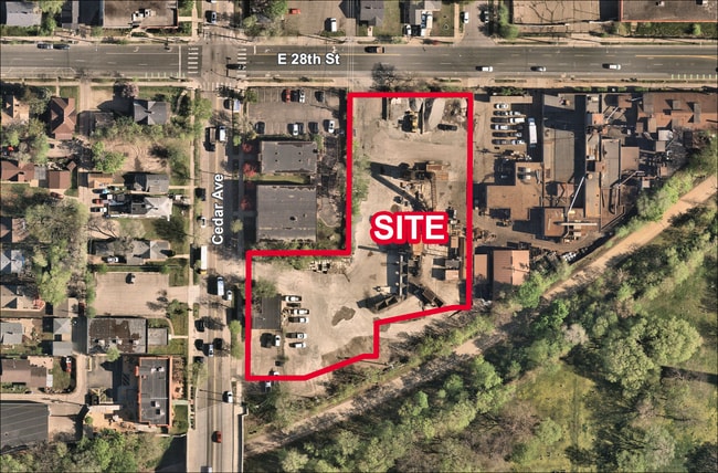
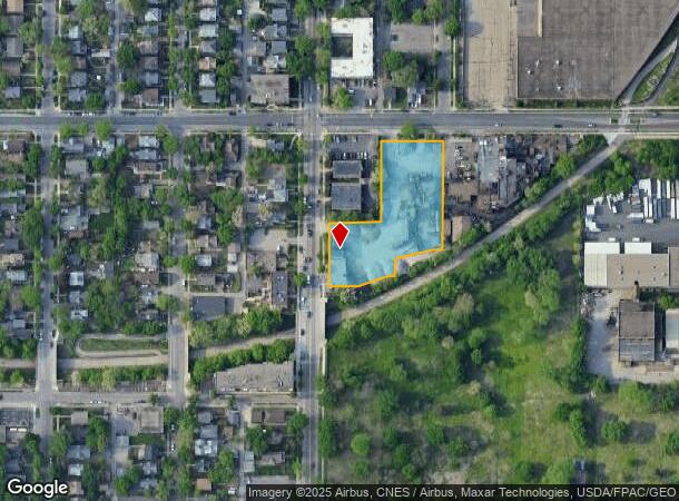
2825 Cedar Ave S, Minneapolis, MN 55407
This Property Is For Sale
NEARBY LISTINGS FOR SALE OR LEASE
Property Detail
2825 Cedar Ave S
Minneapolis/St Paul
Laymans 2Nd Addn To Mpls
Minneapolis-St. Paul-Bloomington, MN-WI
LOT 004 A LAYMANS 2ND ADDN TO MPLS LOTS 4, 5 AND THE EAST 20.5 FEET OF LOTS 1, 2 AND 3, LAYMANS SECOND ADDITION TO MINNEAPOLIS; ALSO THAT PART OF LOTS 6 AND 7 OF SAID ADDITION T IRREGULAR
36-029-24-33-0064
Hennepin
Industrialgeneral
Minnesota
2024
4
2024
1.49 AC
125900
I-394 Corridor
3,840 SF
DEMOGRAPHICS near 2825 Cedar Ave S
1 Mile
3 Mile
5 Mile
2024 Total Population
31,794
265,339
497,896
2029 Population
31,112
263,327
489,993
Pop Growth 2024-2029
(2.15%)
(0.76%)
(1.59%)
Average Age
35
36
37
2024 Total Households
12,066
123,181
221,244
HH Growth 2024-2029
(2.32%)
(0.55%)
(1.48%)
Median Household Inc
$50,730
$65,658
$72,776
Avg Household Size
2.40
2.00
2.10
2024 Avg HH Vehicles
1.00
1.00
1.00
Median Home Value
$263,740
$340,375
$356,135
Median Year Built
1948
1962
1954
Nearby Places
Map Layers
Map Styles
 Street
 Aerial
- Restaurants
- Banks
- Shops
- Fitness
- Groceries
PUBLIC TRANSPORTATION
TRANSIT/SUBWAY
Lake Street/Midtown Station (Hiawatha Line - Minneapolis-Saint Paul Metro Transit Light Rail)
DRIVE
WALK
Distance
Lake Street/Midtown Station (Hiawatha Line - Minneapolis-Saint Paul Metro Transit Light Rail)
1 min
11 min
0.6 mi
Franklin Avenue Station (Hiawatha Line - Minneapolis-Saint Paul Metro Transit Light Rail)
DRIVE
WALK
Distance
Franklin Avenue Station (Hiawatha Line - Minneapolis-Saint Paul Metro Transit Light Rail)
3 min
16 min
0.9 mi
COMMUTER RAIL
Target Field Station (Northstar Corridor - Northstar Commuter Rail)
DRIVE
WALK
Distance
Target Field Station (Northstar Corridor - Northstar Commuter Rail)
9 min
3.3 mi
St. Paul-Minneapolis (Empire Builder - Amtrak)
DRIVE
WALK
Distance
St. Paul-Minneapolis (Empire Builder - Amtrak)
16 min
9.8 mi
AIRPORT
Minneapolis-St Paul International/Wold-Chamberlain
DRIVE
WALK
Distance
Minneapolis-St Paul International/Wold-Chamberlain
17 min
8.4 mi
Freight Ports
Port Milwaukee
DRIVE
WALK
Distance
Port Milwaukee
375 min
338.1 mi
Nearby Properties
Address
Land Use
TOTAL SIZE
Lot Size
Zoning
Address
Land Use
TOTAL SIZE
Lot Size
Zoning
141,277 SF
44.78 AC
Address
Land Use
TOTAL SIZE
Lot Size
Zoning
1,462,182 SF
1 AC
B4-2
Address
Land Use
TOTAL SIZE
Lot Size
Zoning
2,094,377 SF
2.10 AC
B4-2
Address
Land Use
TOTAL SIZE
Lot Size
Zoning
1,821,999 SF
2.51 AC
B4-2
Address
Land Use
TOTAL SIZE
Lot Size
Zoning
Address
Land Use
TOTAL SIZE
Lot Size
Zoning
1,934,403 SF
1.67 AC
B4-2
Address
Land Use
TOTAL SIZE
Lot Size
Zoning
1,021,060 SF
1.71 AC
B4S-2
Address
Land Use
TOTAL SIZE
Lot Size
Zoning
2,282,334 SF
3.25 AC
B4-2
Address
Land Use
TOTAL SIZE
Lot Size
Zoning
1,054,492 SF
1.70 AC
B4-1
Address
Land Use
TOTAL SIZE
Lot Size
Zoning
495,632 SF
1.72 AC
C1
Address
Land Use
TOTAL SIZE
Lot Size
Zoning
1,208,190 SF
1.20 AC
B4-2
Address
Land Use
TOTAL SIZE
Lot Size
Zoning
176,108 SF
27.45 AC
Address
Land Use
TOTAL SIZE
Lot Size
Zoning
621,608 SF
1.03 AC
B4-2
Address
Land Use
TOTAL SIZE
Lot Size
Zoning
458,470 SF
1.18 AC
OR3
Address
Land Use
TOTAL SIZE
Lot Size
Zoning
907,129 SF
1.65 AC
B4-1
Address
Land Use
TOTAL SIZE
Lot Size
Zoning
442,731 SF
0.97 AC
B4S-2
Address
Land Use
TOTAL SIZE
Lot Size
Zoning
1,044,454 SF
1.08 AC
B4-2
Address
Land Use
TOTAL SIZE
Lot Size
Zoning
1,261,574 SF
2.52 AC
B4-2
Address
Land Use
TOTAL SIZE
Lot Size
Zoning
695,624 SF
3.67 AC
C2
Address
Land Use
TOTAL SIZE
Lot Size
Zoning
2.67 AC
C3A
Address
Land Use
TOTAL SIZE
Lot Size
Zoning
615,172 SF
1.98 AC
I1
Address
Land Use
TOTAL SIZE
Lot Size
Zoning
275,782 SF
2.40 AC
C3A
Address
Land Use
TOTAL SIZE
Lot Size
Zoning
722,423 SF
1.33 AC
B4-2
Address
Land Use
TOTAL SIZE
Lot Size
Zoning
1,424,796 SF
1.13 AC
B4-1
Address
Land Use
TOTAL SIZE
Lot Size
Zoning
577,656 SF
2.92 AC
C3A
Address
Land Use
TOTAL SIZE
Lot Size
Zoning
557,654 SF
3.15 AC
C2
Address
Land Use
TOTAL SIZE
Lot Size
Zoning
478,616 SF
2.28 AC
C2
Address
Land Use
TOTAL SIZE
Lot Size
Zoning
513,403 SF
0.73 AC
C2
Address
Land Use
TOTAL SIZE
Lot Size
Zoning
1,235,416 SF
1.12 AC
B4-2
Address
Land Use
TOTAL SIZE
Lot Size
Zoning
323,404 SF
2.54 AC
B4S-2
The World's #1 Commercial Real Estate Marketplace
Connect with us
© 2025 CoStar Group
The information above has been obtained from sources believed reliable. While we do not doubt its accuracy we have not verified it and make no guarantee, warranty or representation about it. It is your responsibility to independently confirm its accuracy and completeness. Any projections, opinions, assumptions, or estimates used are for example only and do not represent the current or future performance of the property. The value of this transaction to you depends on tax and other factors which should be evaluated by your tax, financial, and legal advisors. You and your advisors should conduct a careful, independent investigation of the property to determine to your satisfaction the suitability of the property for your needs.