Property Record
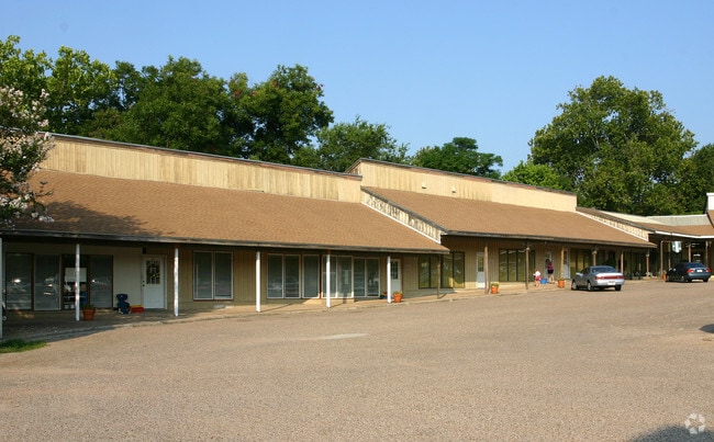
2825 Hancock Dr, Austin, TX 78731


This Property Is For Sale
Property Detail
2825 Hancock Dr
124367
ABS 313 SUR 8 GILBERT D J ACR 1.47
Stripcommercialcenter
TRAVIS
B and X Area of moderate flood hazard, usually the area between the limits of the 100-year and 500-year floods.
Texas
2025
1.47 AC
2025
Central
000101
Austin
19,707 SF
Austin-Round Rock-San Marcos, TX
NEARBY LISTINGS FOR SALE OR LEASE
DEMOGRAPHICS near 2825 Hancock Dr
1 mile
3 mile
5 mile
2025 Total Population
13,164
142,564
347,586
2030 Population
13,850
149,631
364,828
Pop Growth 2025-2030
+ 5.21%
+ 4.96%
+ 4.96%
Average Age
41
36
37
2025 Total Households
6,309
65,795
155,890
HH Growth 2025-2030
+ 5.67%
+ 5.81%
+ 5.86%
Median Household Inc
$117,740
$86,310
$90,710
Avg Household Size
2.00
2.00
2.10
2025 Avg HH Vehicles
2.00
2.00
2.00
Median Home Value
$852,366
$879,883
$817,647
Median Year Built
1972
1981
1987
Nearby Places
Map Layers
Map Styles
 Street
 Aerial
Transit
 Traffic
 Biking
Places
Listings with unknown addresses are not visible on the map
- Restaurants
- Banks
- Shops
- Fitness
- Groceries
PUBLIC TRANSPORTATION
COMMUTER RAIL
Austin (Texas Eagle - Amtrak)
Drive
Walk
Distance
Austin (Texas Eagle - Amtrak)
10 min
5.3 mi
AIRPORT
Austin-Bergstrom International
Drive
Walk
Distance
Austin-Bergstrom International
29 min
15.2 mi
Freight Ports
Calhoun Port
Drive
Walk
Distance
Calhoun Port
194 min
158.6 mi
Nearby Properties
Address
Land Use
TOTAL SIZE
Lot Size
Zoning
Address
Land Use
TOTAL SIZE
Lot Size
Zoning
29,594 SF
155.62 AC
Address
Land Use
TOTAL SIZE
Lot Size
Zoning
28.39 AC
Address
Land Use
TOTAL SIZE
Lot Size
Zoning
74.69 AC
Address
Land Use
TOTAL SIZE
Lot Size
Zoning
623,000 SF
11.78 AC
Address
Land Use
TOTAL SIZE
Lot Size
Zoning
21 AC
Address
Land Use
TOTAL SIZE
Lot Size
Zoning
614,532 SF
66.07 AC
Address
Land Use
TOTAL SIZE
Lot Size
Zoning
552,000 SF
1.21 AC
Address
Land Use
TOTAL SIZE
Lot Size
Zoning
1,234 SF
96.75 AC
Address
Land Use
TOTAL SIZE
Lot Size
Zoning
95.86 AC
Address
Land Use
TOTAL SIZE
Lot Size
Zoning
263,226 SF
1.43 AC
Address
Land Use
TOTAL SIZE
Lot Size
Zoning
973,370 SF
11.26 AC
Address
Land Use
TOTAL SIZE
Lot Size
Zoning
328,340 SF
1.22 AC
Address
Land Use
TOTAL SIZE
Lot Size
Zoning
14.55 AC
Address
Land Use
TOTAL SIZE
Lot Size
Zoning
394,423 SF
0.58 AC
Address
Land Use
TOTAL SIZE
Lot Size
Zoning
73.48 AC
Address
Land Use
TOTAL SIZE
Lot Size
Zoning
339,926 SF
1.34 AC
Address
Land Use
TOTAL SIZE
Lot Size
Zoning
510,500 SF
9.26 AC
Address
Land Use
TOTAL SIZE
Lot Size
Zoning
401,418 SF
4.77 AC
Address
Land Use
TOTAL SIZE
Lot Size
Zoning
Address
Land Use
TOTAL SIZE
Lot Size
Zoning
241,000 SF
0.40 AC
Address
Land Use
TOTAL SIZE
Lot Size
Zoning
377,203 SF
3.53 AC
Address
Land Use
TOTAL SIZE
Lot Size
Zoning
238,650 SF
1.18 AC
Address
Land Use
TOTAL SIZE
Lot Size
Zoning
480,823 SF
18.46 AC
Address
Land Use
TOTAL SIZE
Lot Size
Zoning
346,319 SF
6.53 AC
Address
Land Use
TOTAL SIZE
Lot Size
Zoning
216,956 SF
0.58 AC
Address
Land Use
TOTAL SIZE
Lot Size
Zoning
45 AC
Address
Land Use
TOTAL SIZE
Lot Size
Zoning
303,622 SF
5.21 AC
Address
Land Use
TOTAL SIZE
Lot Size
Zoning
425,200 SF
2.49 AC
Address
Land Use
TOTAL SIZE
Lot Size
Zoning
20.99 AC
The World's #1 Commercial Real Estate Marketplace
Connect with us
© 2026 CoStar Group
The information above has been obtained from sources believed reliable. While we do not doubt its accuracy we have not verified it and make no guarantee, warranty or representation about it. It is your responsibility to independently confirm its accuracy and completeness. Any projections, opinions, assumptions, or estimates used are for example only and do not represent the current or future performance of the property. The value of this transaction to you depends on tax and other factors which should be evaluated by your tax, financial, and legal advisors. You and your advisors should conduct a careful, independent investigation of the property to determine to your satisfaction the suitability of the property for your needs.