Property Record
2825 High St, Oakland, CA 94619


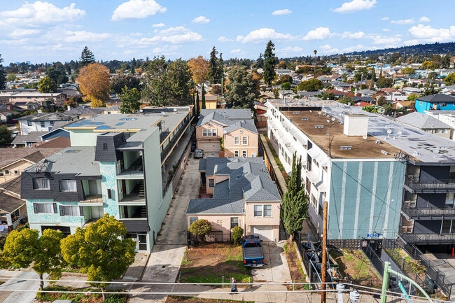
This Property Is For Sale
NEARBY LISTINGS FOR SALE OR LEASE
Property Detail
2825 High St
Oakland-Hayward-Berkeley, CA
Brooklyn Land Co
032-2057-013-00
PORTION LOT4
Multifamilydwelling
Alameda
X
California
06001C0087G
4
2024
0.28 AC
2025
Allendale
407000
East Bay/Oakland
6,904 SF
DEMOGRAPHICS near 2825 High St
1 Mile
3 Mile
5 Mile
2024 Total Population
47,602
240,928
493,514
2029 Population
45,845
232,296
478,767
Pop Growth 2024-2029
(3.69%)
(3.58%)
(2.99%)
Average Age
39
40
41
2024 Total Households
16,153
83,553
188,121
HH Growth 2024-2029
(3.91%)
(3.76%)
(3.01%)
Median Household Inc
$76,054
$81,882
$92,685
Avg Household Size
2.80
2.70
2.50
2024 Avg HH Vehicles
2.00
2.00
2.00
Median Home Value
$725,445
$874,714
$935,900
Median Year Built
1947
1948
1955
Nearby Places
Map Layers
Map Styles
 Street
 Aerial
- Restaurants
- Banks
- Shops
- Fitness
- Groceries
PUBLIC TRANSPORTATION
COMMUTER RAIL
Oakland (Capitol Corridor - Amtrak, Coast Starlight - Amtrak, San Joaquins - Amtrak)
DRIVE
WALK
Distance
Oakland (Capitol Corridor - Amtrak, Coast Starlight - Amtrak, San Joaquins - Amtrak)
9 min
5.2 mi
Emeryville (California Zephyr - Amtrak, Capitol Corridor - Amtrak, Coast Starlight - Amtrak, San Joaquins - Amtrak)
DRIVE
WALK
Distance
Emeryville (California Zephyr - Amtrak, Capitol Corridor - Amtrak, Coast Starlight - Amtrak, San Joaquins - Amtrak)
11 min
8.1 mi
AIRPORT
Metro Oakland International
DRIVE
WALK
Distance
Metro Oakland International
11 min
6.8 mi
San Francisco International
DRIVE
WALK
Distance
San Francisco International
39 min
27.1 mi
Freight Ports
Port of Oakland
DRIVE
WALK
Distance
Port of Oakland
10 min
5.7 mi
Nearby Properties
Address
Land Use
TOTAL SIZE
Lot Size
Zoning
Address
Land Use
TOTAL SIZE
Lot Size
Zoning
371,504 SF
4.08 AC
Address
Land Use
TOTAL SIZE
Lot Size
Zoning
534,208 SF
23.18 AC
Address
Land Use
TOTAL SIZE
Lot Size
Zoning
297,617 SF
1.54 AC
Address
Land Use
TOTAL SIZE
Lot Size
Zoning
525,864 SF
16.53 AC
Address
Land Use
TOTAL SIZE
Lot Size
Zoning
180,959 SF
9.38 AC
Address
Land Use
TOTAL SIZE
Lot Size
Zoning
336,680 SF
9.93 AC
M40
Address
Land Use
TOTAL SIZE
Lot Size
Zoning
133,636 SF
5.46 AC
Address
Land Use
TOTAL SIZE
Lot Size
Zoning
284,255 SF
5.07 AC
Address
Land Use
TOTAL SIZE
Lot Size
Zoning
320,001 SF
37.56 AC
Address
Land Use
TOTAL SIZE
Lot Size
Zoning
165,042 SF
13.50 AC
Address
Land Use
TOTAL SIZE
Lot Size
Zoning
200,238 SF
9.28 AC
Address
Land Use
TOTAL SIZE
Lot Size
Zoning
Address
Land Use
TOTAL SIZE
Lot Size
Zoning
133,678 SF
4.33 AC
Address
Land Use
TOTAL SIZE
Lot Size
Zoning
136,127 SF
8.21 AC
Address
Land Use
TOTAL SIZE
Lot Size
Zoning
129,726 SF
5.38 AC
Address
Land Use
TOTAL SIZE
Lot Size
Zoning
0.94 AC
Address
Land Use
TOTAL SIZE
Lot Size
Zoning
197,321 SF
16.52 AC
Address
Land Use
TOTAL SIZE
Lot Size
Zoning
213,600 SF
10.60 AC
Address
Land Use
TOTAL SIZE
Lot Size
Zoning
1,189,534 SF
26.64 AC
Address
Land Use
TOTAL SIZE
Lot Size
Zoning
204,006 SF
6.39 AC
M40
Address
Land Use
TOTAL SIZE
Lot Size
Zoning
165,638 SF
4.06 AC
Address
Land Use
TOTAL SIZE
Lot Size
Zoning
132,446 SF
4.34 AC
Address
Land Use
TOTAL SIZE
Lot Size
Zoning
6.81 AC
Address
Land Use
TOTAL SIZE
Lot Size
Zoning
112,675 SF
2.07 AC
Address
Land Use
TOTAL SIZE
Lot Size
Zoning
64,421 SF
3.49 AC
Address
Land Use
TOTAL SIZE
Lot Size
Zoning
383,560 SF
18.90 AC
Address
Land Use
TOTAL SIZE
Lot Size
Zoning
58,977 SF
4.22 AC
Address
Land Use
TOTAL SIZE
Lot Size
Zoning
47,468 SF
2.51 AC
Address
Land Use
TOTAL SIZE
Lot Size
Zoning
49,865 SF
0.42 AC
C20
Address
Land Use
TOTAL SIZE
Lot Size
Zoning
78,962 SF
0.94 AC
The World's #1 Commercial Real Estate Marketplace
Connect with us
© 2025 CoStar Group
The information above has been obtained from sources believed reliable. While we do not doubt its accuracy we have not verified it and make no guarantee, warranty or representation about it. It is your responsibility to independently confirm its accuracy and completeness. Any projections, opinions, assumptions, or estimates used are for example only and do not represent the current or future performance of the property. The value of this transaction to you depends on tax and other factors which should be evaluated by your tax, financial, and legal advisors. You and your advisors should conduct a careful, independent investigation of the property to determine to your satisfaction the suitability of the property for your needs.