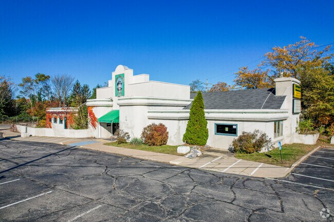
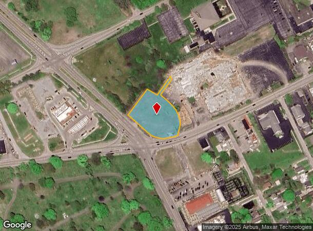
Property Record
2832 W 8Th St, Erie, PA 16505


NEARBY LISTINGS FOR SALE OR LEASE
Property Detail
2832 W 8Th St
33-029-050.0-002.00
2832 W 8TH ST 1.07 AC CAL
Govtadministrativeoffice
Erie
X
Pennsylvania
42049C0182E
1.07 AC
2025
Outlying Erie County
2025
Erie
010500
Erie, PA
8,302 SF
DEMOGRAPHICS near 2832 W 8Th St
1 Mile
3 Mile
5 Mile
2024 Total Population
5,371
55,891
121,950
2029 Population
5,375
55,302
120,817
Pop Growth 2024-2029
+ 0.07%
(1.05%)
(0.93%)
Average Age
46
42
41
2024 Total Households
2,682
24,897
51,404
HH Growth 2024-2029
+ 0.15%
(1.16%)
(1.00%)
Median Household Inc
$61,484
$58,638
$52,278
Avg Household Size
2.00
2.20
2.20
2024 Avg HH Vehicles
1.00
2.00
1.00
Median Home Value
$158,449
$143,797
$148,539
Median Year Built
1959
1957
1957
Nearby Places
Map Layers
Map Styles
 Street
 Aerial
- Restaurants
- Banks
- Shops
- Fitness
- Groceries
PUBLIC TRANSPORTATION
COMMUTER RAIL
Erie Amtrak Station (Lake Shore Limited - Amtrak)
DRIVE
WALK
Distance
Erie Amtrak Station (Lake Shore Limited - Amtrak)
8 min
4.1 mi
AIRPORT
Erie International/Tom Ridge Field
DRIVE
WALK
Distance
Erie International/Tom Ridge Field
5 min
2.4 mi
Freight Ports
Port of Toledo
DRIVE
WALK
Distance
Port of Toledo
250 min
210.7 mi
SALE & LEASE HISTORY
LISTING DATE
SALE/LEASE

Oct 02, 2019
For Sale
Dec 10, 2021
For Lease
Nearby Properties
Address
Land Use
TOTAL SIZE
Lot Size
Zoning
Address
Land Use
TOTAL SIZE
Lot Size
Zoning
24.71 AC
AR
Address
Land Use
TOTAL SIZE
Lot Size
Zoning
10,960 SF
29.82 AC
DR
Address
Land Use
TOTAL SIZE
Lot Size
Zoning
22.02 AC
AR
Address
Land Use
TOTAL SIZE
Lot Size
Zoning
117,879 SF
13.47 AC
M1
Address
Land Use
TOTAL SIZE
Lot Size
Zoning
127,756 SF
7.21 AC
RLB
Address
Land Use
TOTAL SIZE
Lot Size
Zoning
2,754 SF
26.83 AC
DB
Address
Land Use
TOTAL SIZE
Lot Size
Zoning
171,966 SF
13.99 AC
RB
Address
Land Use
TOTAL SIZE
Lot Size
Zoning
65,000 SF
12.11 AC
AB
Address
Land Use
TOTAL SIZE
Lot Size
Zoning
35,669 SF
290.27 AC
LI
Address
Land Use
TOTAL SIZE
Lot Size
Zoning
10.62 AC
R2
Address
Land Use
TOTAL SIZE
Lot Size
Zoning
100,586 SF
4.89 AC
AB
Address
Land Use
TOTAL SIZE
Lot Size
Zoning
47,635 SF
2.97 AC
R1
Address
Land Use
TOTAL SIZE
Lot Size
Zoning
4,600 SF
50.38 AC
R3
Address
Land Use
TOTAL SIZE
Lot Size
Zoning
39,948 SF
5.02 AC
BB
Address
Land Use
TOTAL SIZE
Lot Size
Zoning
9.95 AC
R1
Address
Land Use
TOTAL SIZE
Lot Size
Zoning
41,352 SF
12.21 AC
DR
Address
Land Use
TOTAL SIZE
Lot Size
Zoning
10,096 SF
15.55 AC
DR
Address
Land Use
TOTAL SIZE
Lot Size
Zoning
18.93 AC
AR
Address
Land Use
TOTAL SIZE
Lot Size
Zoning
14.48 AC
Address
Land Use
TOTAL SIZE
Lot Size
Zoning
1.25 AC
R2
Address
Land Use
TOTAL SIZE
Lot Size
Zoning
11.38 AC
R1
Address
Land Use
TOTAL SIZE
Lot Size
Zoning
7.42 AC
M2
Address
Land Use
TOTAL SIZE
Lot Size
Zoning
22.72 AC
AR
Address
Land Use
TOTAL SIZE
Lot Size
Zoning
58,548 SF
17.23 AC
AB
Address
Land Use
TOTAL SIZE
Lot Size
Zoning
2,199 SF
7.05 AC
BB
Address
Land Use
TOTAL SIZE
Lot Size
Zoning
48,923 SF
6.77 AC
AB
Address
Land Use
TOTAL SIZE
Lot Size
Zoning
176,542 SF
23.85 AC
M2
Address
Land Use
TOTAL SIZE
Lot Size
Zoning
16,329 SF
7.18 AC
BB
Address
Land Use
TOTAL SIZE
Lot Size
Zoning
10.01 AC
AR
Address
Land Use
TOTAL SIZE
Lot Size
Zoning
106,348 SF
28.77 AC
RLB
The World's #1 Commercial Real Estate Marketplace
Connect with us
© 2025 CoStar Group
The information above has been obtained from sources believed reliable. While we do not doubt its accuracy we have not verified it and make no guarantee, warranty or representation about it. It is your responsibility to independently confirm its accuracy and completeness. Any projections, opinions, assumptions, or estimates used are for example only and do not represent the current or future performance of the property. The value of this transaction to you depends on tax and other factors which should be evaluated by your tax, financial, and legal advisors. You and your advisors should conduct a careful, independent investigation of the property to determine to your satisfaction the suitability of the property for your needs.