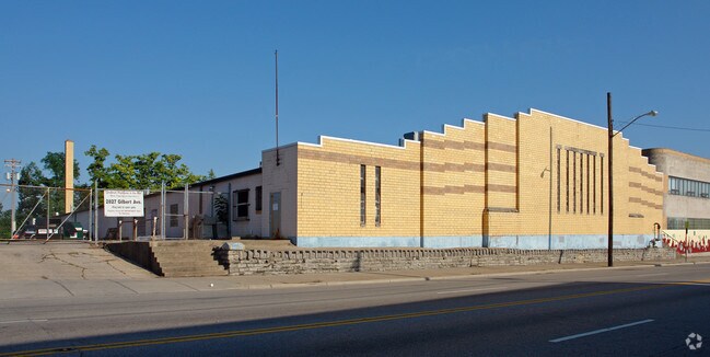
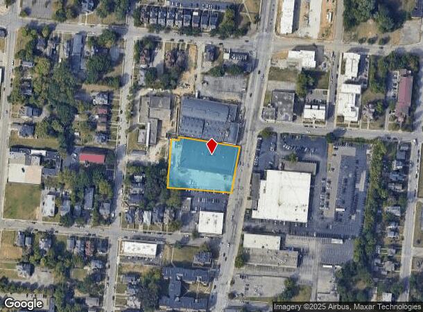
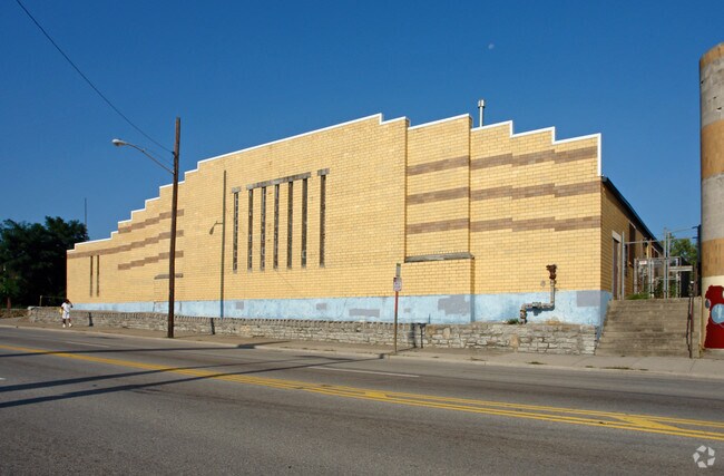
Property Record
2827 Gilbert Ave, Cincinnati, OH 45206
NEARBY LISTINGS FOR SALE OR LEASE
Property Detail
2827 Gilbert Ave
Cincinnati, OH-KY-IN
Kemper Est
065-0002-0055
GILBERT AVE AC IRR PT LOTS 1-8-9 E KEMPER EST PARS 55 THRU 57-147- 149 CONS
Charitableorganization
Hamilton
X
Ohio
39061C0238E
1-8
2024
0.30 AC
2024
Central/Midtown
026700
Cincinnati/Dayton
DEMOGRAPHICS near 2827 Gilbert Ave
1 Mile
3 Mile
5 Mile
2024 Total Population
20,758
158,809
326,368
2029 Population
21,153
160,673
329,221
Pop Growth 2024-2029
+ 1.90%
+ 1.17%
+ 0.87%
Average Age
37
36
37
2024 Total Households
10,476
72,087
147,033
HH Growth 2024-2029
+ 1.50%
+ 1.24%
+ 0.86%
Median Household Inc
$39,711
$54,100
$50,982
Avg Household Size
1.80
1.90
2.00
2024 Avg HH Vehicles
1.00
1.00
1.00
Median Home Value
$241,355
$270,367
$225,845
Median Year Built
1948
1948
1949
Nearby Places
Map Layers
Map Styles
 Street
 Aerial
- Restaurants
- Banks
- Shops
- Fitness
- Groceries
PUBLIC TRANSPORTATION
COMMUTER RAIL
DRIVE
WALK
Distance
11 min
4.7 mi
AIRPORT
Cincinnati/Northern Kentucky International
DRIVE
WALK
Distance
Cincinnati/Northern Kentucky International
28 min
14.9 mi
Nearby Properties
Address
Land Use
TOTAL SIZE
Lot Size
Zoning
Address
Land Use
TOTAL SIZE
Lot Size
Zoning
77.73 AC
IR
Address
Land Use
TOTAL SIZE
Lot Size
Zoning
6.35 AC
IR
Address
Land Use
TOTAL SIZE
Lot Size
Zoning
39.99 AC
MG
Address
Land Use
TOTAL SIZE
Lot Size
Zoning
11.82 AC
Address
Land Use
TOTAL SIZE
Lot Size
Zoning
19.36 AC
Address
Land Use
TOTAL SIZE
Lot Size
Zoning
17.10 AC
DD
Address
Land Use
TOTAL SIZE
Lot Size
Zoning
1.97 AC
DD
Address
Land Use
TOTAL SIZE
Lot Size
Zoning
62.10 AC
Address
Land Use
TOTAL SIZE
Lot Size
Zoning
11.41 AC
IR
Address
Land Use
TOTAL SIZE
Lot Size
Zoning
22.45 AC
Address
Land Use
TOTAL SIZE
Lot Size
Zoning
13.80 AC
Address
Land Use
TOTAL SIZE
Lot Size
Zoning
9.55 AC
Address
Land Use
TOTAL SIZE
Lot Size
Zoning
3.09 AC
Address
Land Use
TOTAL SIZE
Lot Size
Zoning
2.80 AC
IR
Address
Land Use
TOTAL SIZE
Lot Size
Zoning
3.40 AC
IR
Address
Land Use
TOTAL SIZE
Lot Size
Zoning
Address
Land Use
TOTAL SIZE
Lot Size
Zoning
3.51 AC
DD
Address
Land Use
TOTAL SIZE
Lot Size
Zoning
21.34 AC
Address
Land Use
TOTAL SIZE
Lot Size
Zoning
27.30 AC
M2
Address
Land Use
TOTAL SIZE
Lot Size
Zoning
Address
Land Use
TOTAL SIZE
Lot Size
Zoning
153,312 SF
4 AC
Address
Land Use
TOTAL SIZE
Lot Size
Zoning
9.14 AC
Address
Land Use
TOTAL SIZE
Lot Size
Zoning
11.68 AC
Address
Land Use
TOTAL SIZE
Lot Size
Zoning
7.14 AC
Address
Land Use
TOTAL SIZE
Lot Size
Zoning
1.95 AC
Address
Land Use
TOTAL SIZE
Lot Size
Zoning
26,453 SF
19.91 AC
M2
Address
Land Use
TOTAL SIZE
Lot Size
Zoning
Address
Land Use
TOTAL SIZE
Lot Size
Zoning
2.46 AC
Address
Land Use
TOTAL SIZE
Lot Size
Zoning
844,128 SF
1.22 AC
DD
Address
Land Use
TOTAL SIZE
Lot Size
Zoning
0.43 AC
DD
The World's #1 Commercial Real Estate Marketplace
Connect with us
© 2026 CoStar Group
The information above has been obtained from sources believed reliable. While we do not doubt its accuracy we have not verified it and make no guarantee, warranty or representation about it. It is your responsibility to independently confirm its accuracy and completeness. Any projections, opinions, assumptions, or estimates used are for example only and do not represent the current or future performance of the property. The value of this transaction to you depends on tax and other factors which should be evaluated by your tax, financial, and legal advisors. You and your advisors should conduct a careful, independent investigation of the property to determine to your satisfaction the suitability of the property for your needs.