Property Record
2828 Egypt Rd, Norristown, PA 19403

NEARBY LISTINGS FOR SALE OR LEASE
Property Detail
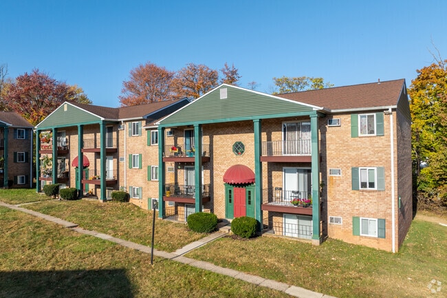
2828 Egypt Rd
Philadelphia-Camden-Wilmington, PA-NJ-DE-MD
Audobon Courts Apts
43-00-03523-007
ASSESSOR BLOCK-UNIT NUMBER 57-32
Apartment
Montgomery
X
Pennsylvania
42091C0245G
32
2024
10 AC
2025
Norristown
203402
Philadelphia
154,825 SF
DEMOGRAPHICS near 2828 Egypt Rd
1 Mile
3 Mile
5 Mile
2024 Total Population
4,813
42,597
148,862
2029 Population
4,901
43,370
152,429
Pop Growth 2024-2029
+ 1.83%
+ 1.81%
+ 2.40%
Average Age
39
42
41
2024 Total Households
1,773
16,803
58,748
HH Growth 2024-2029
+ 1.69%
+ 1.74%
+ 2.57%
Median Household Inc
$98,002
$110,953
$105,848
Avg Household Size
2.60
2.40
2.40
2024 Avg HH Vehicles
2.00
2.00
2.00
Median Home Value
$390,096
$393,991
$389,328
Median Year Built
1980
1982
1976
Nearby Places
Map Layers
Map Styles
 Street
 Aerial
- Restaurants
- Banks
- Shops
- Fitness
- Groceries
PUBLIC TRANSPORTATION
COMMUTER RAIL
Main Street (Norristown) (R6 - Southeastern Pennsylvania Transportation Authority Regional Rail (SEPTA Regional Rail))
DRIVE
WALK
Distance
Main Street (Norristown) (R6 - Southeastern Pennsylvania Transportation Authority Regional Rail (SEPTA Regional Rail))
12 min
5.3 mi
Elm Street (Norristown) (R6 - Southeastern Pennsylvania Transportation Authority Regional Rail (SEPTA Regional Rail))
DRIVE
WALK
Distance
Elm Street (Norristown) (R6 - Southeastern Pennsylvania Transportation Authority Regional Rail (SEPTA Regional Rail))
12 min
5.7 mi
AIRPORT
Philadelphia International
DRIVE
WALK
Distance
Philadelphia International
50 min
31.4 mi
Freight Ports
South Jersey Port
DRIVE
WALK
Distance
South Jersey Port
44 min
27.5 mi
Nearby Properties
Address
Land Use
TOTAL SIZE
Lot Size
Zoning
Address
Land Use
TOTAL SIZE
Lot Size
Zoning
989,814 SF
8.87 AC
IO
Address
Land Use
TOTAL SIZE
Lot Size
Zoning
50,149 SF
26.72 AC
I/L1
Address
Land Use
TOTAL SIZE
Lot Size
Zoning
58,212 SF
20.89 AC
M2
Address
Land Use
TOTAL SIZE
Lot Size
Zoning
1,145,005 SF
149.21 AC
IO
Address
Land Use
TOTAL SIZE
Lot Size
Zoning
124,789 SF
155.99 AC
INO
Address
Land Use
TOTAL SIZE
Lot Size
Zoning
972,935 SF
20.51 AC
INO
Address
Land Use
TOTAL SIZE
Lot Size
Zoning
388,042 SF
24.45 AC
SM
Address
Land Use
TOTAL SIZE
Lot Size
Zoning
617,174 SF
25.32 AC
HR
Address
Land Use
TOTAL SIZE
Lot Size
Zoning
454,933 SF
17.85 AC
SM
Address
Land Use
TOTAL SIZE
Lot Size
Zoning
502,080 SF
11.36 AC
RA
Address
Land Use
TOTAL SIZE
Lot Size
Zoning
348,190 SF
68 AC
R1
Address
Land Use
TOTAL SIZE
Lot Size
Zoning
488,970 SF
24.68 AC
AR
Address
Land Use
TOTAL SIZE
Lot Size
Zoning
503,942 SF
11.26 AC
RA
Address
Land Use
TOTAL SIZE
Lot Size
Zoning
1,470,449 SF
80.02 AC
R1
Address
Land Use
TOTAL SIZE
Lot Size
Zoning
199,873 SF
71.47 AC
INO
Address
Land Use
TOTAL SIZE
Lot Size
Zoning
400,875 SF
32.32 AC
IO
Address
Land Use
TOTAL SIZE
Lot Size
Zoning
381,927 SF
5.10 AC
SM
Address
Land Use
TOTAL SIZE
Lot Size
Zoning
396,137 SF
2.26 AC
HR
Address
Land Use
TOTAL SIZE
Lot Size
Zoning
435,884 SF
26.70 AC
R5
Address
Land Use
TOTAL SIZE
Lot Size
Zoning
273,724 SF
8.05 AC
INO
Address
Land Use
TOTAL SIZE
Lot Size
Zoning
204,483 SF
25.02 AC
IO
Address
Land Use
TOTAL SIZE
Lot Size
Zoning
811,455 SF
18.15 AC
M1
Address
Land Use
TOTAL SIZE
Lot Size
Zoning
1,305,221 SF
21.99 AC
M1
Address
Land Use
TOTAL SIZE
Lot Size
Zoning
639,052 SF
45 AC
SM
Address
Land Use
TOTAL SIZE
Lot Size
Zoning
68,865 SF
20.63 AC
AR
Address
Land Use
TOTAL SIZE
Lot Size
Zoning
208,680 SF
4.54 AC
LCI
Address
Land Use
TOTAL SIZE
Lot Size
Zoning
305,760 SF
22.50 AC
R2
Address
Land Use
TOTAL SIZE
Lot Size
Zoning
303,000 SF
13.63 AC
AR1
Address
Land Use
TOTAL SIZE
Lot Size
Zoning
252,272 SF
18.86 AC
A
Address
Land Use
TOTAL SIZE
Lot Size
Zoning
276,284 SF
3.87 AC
INO
The World's #1 Commercial Real Estate Marketplace
Connect with us
© 2026 CoStar Group
The information above has been obtained from sources believed reliable. While we do not doubt its accuracy we have not verified it and make no guarantee, warranty or representation about it. It is your responsibility to independently confirm its accuracy and completeness. Any projections, opinions, assumptions, or estimates used are for example only and do not represent the current or future performance of the property. The value of this transaction to you depends on tax and other factors which should be evaluated by your tax, financial, and legal advisors. You and your advisors should conduct a careful, independent investigation of the property to determine to your satisfaction the suitability of the property for your needs.