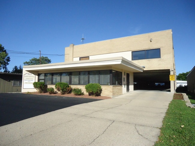
Property Record
2829 Perry St, Madison, WI 53713

Property Detail
2829 Perry St
Madison, WI
LOT 2 CSM 9255 CS52/188-190 4/13/99 DESCR AS SEC 35-7-9 PRT SE1/4SW1/4 (.352 ACR ES) (OUR OWNERSHIP RECORDS DON'T SUPPORT THE ROAD DEDICATION)
0709-353-9702-5
Dane
Commercialnec
Wisconsin
IL
2
2023
0.35 AC
2023
S Central Madison
001405
Milwaukee/Madison
34,700 SF
NEARBY LISTINGS FOR SALE OR LEASE
DEMOGRAPHICS near 2829 Perry St
1 mile
3 mile
5 mile
2024 Total Population
9,620
100,238
220,073
2029 Population
10,139
106,132
234,139
Pop Growth 2024-2029
+ 5.40%
+ 5.88%
+ 6.39%
Average Age
35
34
36
2024 Total Households
4,440
43,010
97,459
HH Growth 2024-2029
+ 5.83%
+ 6.24%
+ 6.78%
Median Household Inc
$52,260
$59,379
$68,443
Avg Household Size
2.10
2.10
2.10
2024 Avg HH Vehicles
1.00
1.00
1.00
Median Home Value
$259,025
$445,370
$415,517
Median Year Built
1981
1988
1980
Nearby Places
Map Layers
Map Styles
 Street
 Aerial
Transit
 Traffic
 Biking
Places
Listings with unknown addresses are not visible on the map
- Restaurants
- Banks
- Shops
- Fitness
- Groceries
PUBLIC TRANSPORTATION
AIRPORT
Dane County Regional/Truax Field
Drive
Walk
Distance
Dane County Regional/Truax Field
22 min
10.6 mi
SALE & LEASE HISTORY
LISTING DATE
SALE/LEASE

Sep 25, 2016
For Lease
Mar 05, 2025
For Lease
Jul 19, 2024
For Lease
Nearby Properties
Address
Land Use
TOTAL SIZE
Lot Size
Zoning
Address
Land Use
TOTAL SIZE
Lot Size
Zoning
489,181 SF
1.82 AC
PD
Address
Land Use
TOTAL SIZE
Lot Size
Zoning
459,624 SF
1.62 AC
DC
Address
Land Use
TOTAL SIZE
Lot Size
Zoning
383,873 SF
0.99 AC
UMX
Address
Land Use
TOTAL SIZE
Lot Size
Zoning
324,916 SF
1.08 AC
PD
Address
Land Use
TOTAL SIZE
Lot Size
Zoning
466,790 SF
761.23 AC
PD
Address
Land Use
TOTAL SIZE
Lot Size
Zoning
8.42 AC
Address
Land Use
TOTAL SIZE
Lot Size
Zoning
21.49 AC
Address
Land Use
TOTAL SIZE
Lot Size
Zoning
374,339 SF
1.43 AC
UMX
Address
Land Use
TOTAL SIZE
Lot Size
Zoning
212,429 SF
0.66 AC
UMX
Address
Land Use
TOTAL SIZE
Lot Size
Zoning
210,515 SF
0.80 AC
UMX
Address
Land Use
TOTAL SIZE
Lot Size
Zoning
259,663 SF
414.76 AC
PD
Address
Land Use
TOTAL SIZE
Lot Size
Zoning
177,906 SF
5.49 AC
CC-T
Address
Land Use
TOTAL SIZE
Lot Size
Zoning
188,206 SF
0.80 AC
UMX
Address
Land Use
TOTAL SIZE
Lot Size
Zoning
158,832 SF
0.58 AC
WP-17
Address
Land Use
TOTAL SIZE
Lot Size
Zoning
403,079 SF
1.08 AC
WP-17
Address
Land Use
TOTAL SIZE
Lot Size
Zoning
18.97 AC
Address
Land Use
TOTAL SIZE
Lot Size
Zoning
212,259 SF
0.87 AC
UMX
Address
Land Use
TOTAL SIZE
Lot Size
Zoning
242,105 SF
2.23 AC
TSS
Address
Land Use
TOTAL SIZE
Lot Size
Zoning
24.62 AC
Address
Land Use
TOTAL SIZE
Lot Size
Zoning
174,113 SF
2.71 AC
PD
Address
Land Use
TOTAL SIZE
Lot Size
Zoning
202,376 SF
1.59 AC
PD
Address
Land Use
TOTAL SIZE
Lot Size
Zoning
230,007 SF
0.76 AC
PD
Address
Land Use
TOTAL SIZE
Lot Size
Zoning
153,684 SF
0.50 AC
DC
Address
Land Use
TOTAL SIZE
Lot Size
Zoning
181,893 SF
0.64 AC
PD
Address
Land Use
TOTAL SIZE
Lot Size
Zoning
14.47 AC
Address
Land Use
TOTAL SIZE
Lot Size
Zoning
135,478 SF
0.41 AC
UMX
Address
Land Use
TOTAL SIZE
Lot Size
Zoning
2.97 AC
Address
Land Use
TOTAL SIZE
Lot Size
Zoning
104,936 SF
1.19 AC
PD
Address
Land Use
TOTAL SIZE
Lot Size
Zoning
425,812 SF
1 AC
WP-17
Address
Land Use
TOTAL SIZE
Lot Size
Zoning
6.30 AC
The World's #1 Commercial Real Estate Marketplace
Connect with us
© 2026 CoStar Group
The information above has been obtained from sources believed reliable. While we do not doubt its accuracy we have not verified it and make no guarantee, warranty or representation about it. It is your responsibility to independently confirm its accuracy and completeness. Any projections, opinions, assumptions, or estimates used are for example only and do not represent the current or future performance of the property. The value of this transaction to you depends on tax and other factors which should be evaluated by your tax, financial, and legal advisors. You and your advisors should conduct a careful, independent investigation of the property to determine to your satisfaction the suitability of the property for your needs.