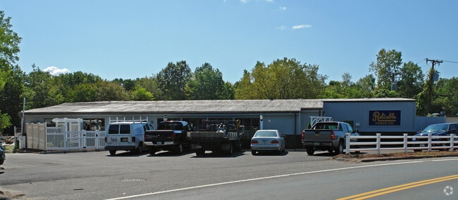
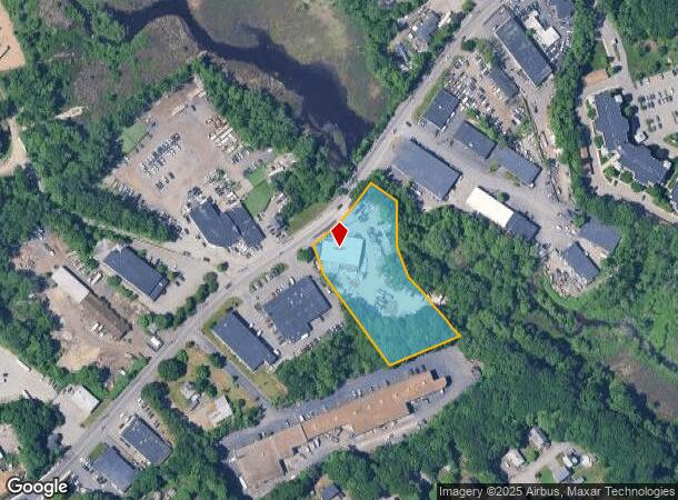
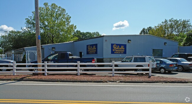
Property Record
283 Salem St, Woburn, MA 01801
NEARBY LISTINGS FOR SALE OR LEASE
Property Detail
283 Salem St
WOBU-000038-000002-000085
Middlesex
Manufacturinglight
Massachusetts
AE
85
25017C0407F
2.01 AC
2025
Wilmington/Winchester
2025
Boston
333400
Boston-Cambridge-Newton, MA-NH
6,524 SF
DEMOGRAPHICS near 283 Salem St
1 mile
3 mile
5 mile
2024 Total Population
8,467
102,835
245,823
2029 Population
8,362
102,162
243,240
Pop Growth 2024-2029
(1.24%)
(0.65%)
(1.05%)
Average Age
42
42
42
2024 Total Households
3,380
41,074
95,279
HH Growth 2024-2029
(1.33%)
(0.72%)
(1.14%)
Median Household Inc
$101,728
$111,871
$126,073
Avg Household Size
2.50
2.40
2.50
2024 Avg HH Vehicles
2.00
2.00
2.00
Median Home Value
$606,557
$699,047
$730,544
Median Year Built
1966
1963
1959
Nearby Places
Map Layers
Map Styles
 Street
 Aerial
Transit
 Traffic
 Biking
Places
Listings with unknown addresses are not visible on the map
- Restaurants
- Banks
- Shops
- Fitness
- Groceries
PUBLIC TRANSPORTATION
COMMUTER RAIL
Anderson/Woburn Regional Transportation Center (Lowell Line - Massachusetts Bay Transportation Authority Commuter Rail (Purple Line))
Drive
Walk
Distance
Anderson/Woburn Regional Transportation Center (Lowell Line - Massachusetts Bay Transportation Authority Commuter Rail (Purple Line))
8 min
2.8 mi
Reading (Haverhill Line - Massachusetts Bay Transportation Authority Commuter Rail (Purple Line))
Drive
Walk
Distance
Reading (Haverhill Line - Massachusetts Bay Transportation Authority Commuter Rail (Purple Line))
7 min
2.8 mi
AIRPORT
General Edward Lawrence Logan International
Drive
Walk
Distance
General Edward Lawrence Logan International
23 min
13.7 mi
Manchester Boston Regional
Drive
Walk
Distance
Manchester Boston Regional
58 min
41.5 mi
Freight Ports
Port of Boston
Drive
Walk
Distance
Port of Boston
23 min
13.4 mi
Nearby Properties
Address
Land Use
TOTAL SIZE
Lot Size
Zoning
Address
Land Use
TOTAL SIZE
Lot Size
Zoning
42.20 AC
S-2
Address
Land Use
TOTAL SIZE
Lot Size
Zoning
169 AC
OS
Address
Land Use
TOTAL SIZE
Lot Size
Zoning
14.97 AC
C
Address
Land Use
TOTAL SIZE
Lot Size
Zoning
388,978 SF
23.23 AC
RG
Address
Land Use
TOTAL SIZE
Lot Size
Zoning
27.56 AC
R-2
Address
Land Use
TOTAL SIZE
Lot Size
Zoning
153,732 SF
12.50 AC
SCI
Address
Land Use
TOTAL SIZE
Lot Size
Zoning
476,332 SF
5.37 AC
Address
Land Use
TOTAL SIZE
Lot Size
Zoning
405,606 SF
33.40 AC
RO
Address
Land Use
TOTAL SIZE
Lot Size
Zoning
18.62 AC
O-P
Address
Land Use
TOTAL SIZE
Lot Size
Zoning
411,956 SF
23.94 AC
S20
Address
Land Use
TOTAL SIZE
Lot Size
Zoning
30.92 AC
RO
Address
Land Use
TOTAL SIZE
Lot Size
Zoning
720 SF
632 AC
SA8
Address
Land Use
TOTAL SIZE
Lot Size
Zoning
186,516 SF
40 AC
R-1
Address
Land Use
TOTAL SIZE
Lot Size
Zoning
31.56 AC
HB
Address
Land Use
TOTAL SIZE
Lot Size
Zoning
7.90 AC
PD
Address
Land Use
TOTAL SIZE
Lot Size
Zoning
191,050 SF
3.15 AC
Address
Land Use
TOTAL SIZE
Lot Size
Zoning
9.01 AC
S-I
Address
Land Use
TOTAL SIZE
Lot Size
Zoning
341,593 SF
3.38 AC
I-P2
Address
Land Use
TOTAL SIZE
Lot Size
Zoning
129,028 SF
7.17 AC
I-P2
Address
Land Use
TOTAL SIZE
Lot Size
Zoning
127.30 AC
R-1
Address
Land Use
TOTAL SIZE
Lot Size
Zoning
27.90 AC
I-P2
Address
Land Use
TOTAL SIZE
Lot Size
Zoning
157,305 SF
10.69 AC
RDB
Address
Land Use
TOTAL SIZE
Lot Size
Zoning
172,056 SF
I
Address
Land Use
TOTAL SIZE
Lot Size
Zoning
17.65 AC
B-I
Address
Land Use
TOTAL SIZE
Lot Size
Zoning
10.73 AC
I-P2
Address
Land Use
TOTAL SIZE
Lot Size
Zoning
19.66 AC
BG
Address
Land Use
TOTAL SIZE
Lot Size
Zoning
5.63 AC
C
Address
Land Use
TOTAL SIZE
Lot Size
Zoning
8.17 AC
RB
Address
Land Use
TOTAL SIZE
Lot Size
Zoning
6.28 AC
RB
Address
Land Use
TOTAL SIZE
Lot Size
Zoning
216,337 SF
7.19 AC
S20
The World's #1 Commercial Real Estate Marketplace
Connect with us
© 2026 CoStar Group
The information above has been obtained from sources believed reliable. While we do not doubt its accuracy we have not verified it and make no guarantee, warranty or representation about it. It is your responsibility to independently confirm its accuracy and completeness. Any projections, opinions, assumptions, or estimates used are for example only and do not represent the current or future performance of the property. The value of this transaction to you depends on tax and other factors which should be evaluated by your tax, financial, and legal advisors. You and your advisors should conduct a careful, independent investigation of the property to determine to your satisfaction the suitability of the property for your needs.