Property Record
2830 E 130Th St, Cleveland, OH 44120
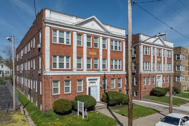
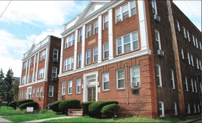

This Property Is For Sale
NEARBY LISTINGS FOR SALE OR LEASE
Property Detail
2830 E 130Th St
Cleveland-Elyria, OH
Kuster
129-17-064
429 KUSTER SL 68 ALL 0067 SP
Apartment
Cuyahoga
X
Ohio
39035C0202E
67
2024
0.17 AC
2024
Buckeye-Shaker
119502
Cleveland
16,198 SF
DEMOGRAPHICS near 2830 E 130Th St
1 Mile
3 Mile
5 Mile
2024 Total Population
20,593
148,050
337,759
2029 Population
20,088
145,478
332,651
Pop Growth 2024-2029
(2.45%)
(1.74%)
(1.51%)
Average Age
41
40
40
2024 Total Households
10,381
66,427
147,052
HH Growth 2024-2029
(2.67%)
(1.80%)
(1.55%)
Median Household Inc
$36,560
$39,613
$39,215
Avg Household Size
1.90
2.10
2.20
2024 Avg HH Vehicles
1.00
1.00
1.00
Median Home Value
$128,104
$122,976
$105,419
Median Year Built
1947
1947
1948
Nearby Places
- Restaurants
- Banks
- Shops
- Fitness
- Groceries
PUBLIC TRANSPORTATION
TRANSIT/SUBWAY
Shaker Square (Blue Line - Greater Cleveland Regional Transit Authority Rapid Transit (The Rapid), Green Line - Greater Cleveland Regional Transit Authority Rapid Transit (The Rapid))
DRIVE
WALK
Distance
Shaker Square (Blue Line - Greater Cleveland Regional Transit Authority Rapid Transit (The Rapid), Green Line - Greater Cleveland Regional Transit Authority Rapid Transit (The Rapid))
1 min
6 min
0.3 mi
Drexmore (Blue Line - Greater Cleveland Regional Transit Authority Rapid Transit (The Rapid))
DRIVE
WALK
Distance
Drexmore (Blue Line - Greater Cleveland Regional Transit Authority Rapid Transit (The Rapid))
1 min
5 min
0.3 mi
South Woodland (Blue Line - Greater Cleveland Regional Transit Authority Rapid Transit (The Rapid))
DRIVE
WALK
Distance
South Woodland (Blue Line - Greater Cleveland Regional Transit Authority Rapid Transit (The Rapid))
2 min
9 min
0.5 mi
Coventry (Green Line - Greater Cleveland Regional Transit Authority Rapid Transit (The Rapid))
DRIVE
WALK
Distance
Coventry (Green Line - Greater Cleveland Regional Transit Authority Rapid Transit (The Rapid))
2 min
11 min
0.5 mi
East 116 (Blue Line - Greater Cleveland Regional Transit Authority Rapid Transit (The Rapid), Green Line - Greater Cleveland Regional Transit Authority Rapid Transit (The Rapid))
DRIVE
WALK
Distance
East 116 (Blue Line - Greater Cleveland Regional Transit Authority Rapid Transit (The Rapid), Green Line - Greater Cleveland Regional Transit Authority Rapid Transit (The Rapid))
3 min
18 min
0.9 mi
COMMUTER RAIL
Cleveland Lakefront Station (Blue Line - Greater Cleveland Regional Transit Authority Rapid Transit (The Rapid), Green Line - Greater Cleveland Regional Transit Authority Rapid Transit (The Rapid))
DRIVE
WALK
Distance
Cleveland Lakefront Station (Blue Line - Greater Cleveland Regional Transit Authority Rapid Transit (The Rapid), Green Line - Greater Cleveland Regional Transit Authority Rapid Transit (The Rapid))
21 min
7.8 mi
DRIVE
WALK
Distance
21 min
8.4 mi
AIRPORT
Cleveland-Hopkins International
DRIVE
WALK
Distance
Cleveland-Hopkins International
29 min
17.2 mi
Nearby Properties
Address
Land Use
TOTAL SIZE
Lot Size
Zoning
Address
Land Use
TOTAL SIZE
Lot Size
Zoning
3,172,147 SF
20.33 AC
GR
Address
Land Use
TOTAL SIZE
Lot Size
Zoning
1,211,519 SF
13.57 AC
GR
Address
Land Use
TOTAL SIZE
Lot Size
Zoning
2,064,168 SF
17.90 AC
GR
Address
Land Use
TOTAL SIZE
Lot Size
Zoning
1,104,152 SF
13.96 AC
GR
Address
Land Use
TOTAL SIZE
Lot Size
Zoning
942,168 SF
8.34 AC
IR
Address
Land Use
TOTAL SIZE
Lot Size
Zoning
53.85 AC
2F
Address
Land Use
TOTAL SIZE
Lot Size
Zoning
1,211,519 SF
13.63 AC
GR
Address
Land Use
TOTAL SIZE
Lot Size
Zoning
484,355 SF
11.60 AC
GR
Address
Land Use
TOTAL SIZE
Lot Size
Zoning
370,230 SF
4.08 AC
GR
Address
Land Use
TOTAL SIZE
Lot Size
Zoning
1,151,581 SF
10.13 AC
L1F
Address
Land Use
TOTAL SIZE
Lot Size
Zoning
500,042 SF
1.34 AC
1F
Address
Land Use
TOTAL SIZE
Lot Size
Zoning
592,922 SF
11.72 AC
GR
Address
Land Use
TOTAL SIZE
Lot Size
Zoning
1,227,793 SF
6.80 AC
GR
Address
Land Use
TOTAL SIZE
Lot Size
Zoning
595,671 SF
14.98 AC
MF3+
Address
Land Use
TOTAL SIZE
Lot Size
Zoning
128,967 SF
3.54 AC
Address
Land Use
TOTAL SIZE
Lot Size
Zoning
913,527 SF
5.17 AC
GR
Address
Land Use
TOTAL SIZE
Lot Size
Zoning
942,168 SF
9.93 AC
IR
Address
Land Use
TOTAL SIZE
Lot Size
Zoning
707,658 SF
17.57 AC
2F
Address
Land Use
TOTAL SIZE
Lot Size
Zoning
230,820 SF
41.47 AC
UI
Address
Land Use
TOTAL SIZE
Lot Size
Zoning
243,720 SF
0.20 AC
GR
Address
Land Use
TOTAL SIZE
Lot Size
Zoning
374,227 SF
13.10 AC
MF3+
Address
Land Use
TOTAL SIZE
Lot Size
Zoning
724,884 SF
8.67 AC
Address
Land Use
TOTAL SIZE
Lot Size
Zoning
435,964 SF
55.03 AC
1F
Address
Land Use
TOTAL SIZE
Lot Size
Zoning
455,560 SF
1.23 AC
GR
Address
Land Use
TOTAL SIZE
Lot Size
Zoning
395,625 SF
0.74 AC
Address
Land Use
TOTAL SIZE
Lot Size
Zoning
745,953 SF
14.34 AC
MF3+
Address
Land Use
TOTAL SIZE
Lot Size
Zoning
767,400 SF
0.27 AC
GR
Address
Land Use
TOTAL SIZE
Lot Size
Zoning
143,000 SF
2.68 AC
MF3+
Address
Land Use
TOTAL SIZE
Lot Size
Zoning
252,736 SF
3.71 AC
GR
Address
Land Use
TOTAL SIZE
Lot Size
Zoning
794,077 SF
3.15 AC
IR
The World's #1 Commercial Real Estate Marketplace
Connect with us
© 2025 CoStar Group
The information above has been obtained from sources believed reliable. While we do not doubt its accuracy we have not verified it and make no guarantee, warranty or representation about it. It is your responsibility to independently confirm its accuracy and completeness. Any projections, opinions, assumptions, or estimates used are for example only and do not represent the current or future performance of the property. The value of this transaction to you depends on tax and other factors which should be evaluated by your tax, financial, and legal advisors. You and your advisors should conduct a careful, independent investigation of the property to determine to your satisfaction the suitability of the property for your needs.