Property Record
28300 Se Highway 212, Boring, OR 97009
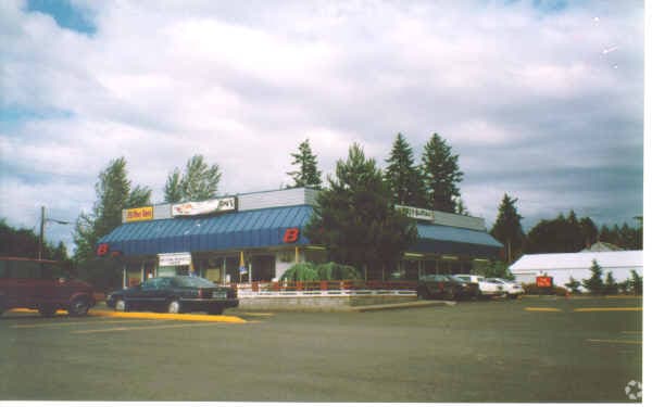


Property Detail
28300 Se Highway 212
01351129
SECTION 06 TOWNSHIP 2S RANGE 4E QUARTER BB TAX LOT 00801
Commercialbuilding
Clackamas
RC
Oregon
B and X Area of moderate flood hazard, usually the area between the limits of the 100-year and 500-year floods.
801
2025
0.94 AC
2025
SE Outlying
023300
Portland
3,162 SF
Portland-Vancouver-Hillsboro, OR-WA
NEARBY LISTINGS FOR SALE OR LEASE
DEMOGRAPHICS near 28300 Se Highway 212
1 mile
3 mile
5 mile
2025 Total Population
1,730
9,359
51,553
2030 Population
1,713
9,271
51,017
Pop Growth 2025-2030
(0.98%)
(0.94%)
(1.04%)
Average Age
45
45
42
2025 Total Households
602
3,199
17,570
HH Growth 2025-2030
(1.00%)
(1.13%)
(1.30%)
Median Household Inc
$126,020
$120,774
$99,853
Avg Household Size
2.80
2.80
2.80
2025 Avg HH Vehicles
3.00
3.00
2.00
Median Home Value
$723,275
$712,915
$595,867
Median Year Built
1975
1977
1984
Nearby Places
Map Layers
Map Styles
 Street
 Aerial
Layers
 Traffic
 Biking
Places
Listings with unknown addresses are not visible on the map
- Restaurants
- Banks
- Shops
- Fitness
- Groceries
PUBLIC TRANSPORTATION
AIRPORT
Portland International
Drive
Walk
Distance
Portland International
34 min
19.8 mi
Freight Ports
Port of Portland
Drive
Walk
Distance
Port of Portland
41 min
25.2 mi
Nearby Properties
Address
Land Use
TOTAL SIZE
Lot Size
Zoning
Address
Land Use
TOTAL SIZE
Lot Size
Zoning
102,431 SF
11.56 AC
RC
Address
Land Use
TOTAL SIZE
Lot Size
Zoning
7.80 AC
FF10
Address
Land Use
TOTAL SIZE
Lot Size
Zoning
1,015 SF
7.45 AC
FF10
Address
Land Use
TOTAL SIZE
Lot Size
Zoning
Address
Land Use
TOTAL SIZE
Lot Size
Zoning
5.62 AC
RI
Address
Land Use
TOTAL SIZE
Lot Size
Zoning
5,376 SF
9.60 AC
RRFF5
Address
Land Use
TOTAL SIZE
Lot Size
Zoning
13,700 SF
4.80 AC
LDR7
Address
Land Use
TOTAL SIZE
Lot Size
Zoning
3,176 SF
4 AC
RA1
Address
Land Use
TOTAL SIZE
Lot Size
Zoning
9.21 AC
RI
Address
Land Use
TOTAL SIZE
Lot Size
Zoning
9,345 SF
4.94 AC
MUA20
Address
Land Use
TOTAL SIZE
Lot Size
Zoning
4.23 AC
RI
Address
Land Use
TOTAL SIZE
Lot Size
Zoning
1,228 SF
2.75 AC
RI
Address
Land Use
TOTAL SIZE
Lot Size
Zoning
3.56 AC
RC
Address
Land Use
TOTAL SIZE
Lot Size
Zoning
400 SF
0.75 AC
RC
Address
Land Use
TOTAL SIZE
Lot Size
Zoning
8,000 SF
2 AC
RC
Address
Land Use
TOTAL SIZE
Lot Size
Zoning
2,300 SF
3.10 AC
RRFF5
Address
Land Use
TOTAL SIZE
Lot Size
Zoning
32,010 SF
2.53 AC
RC
Address
Land Use
TOTAL SIZE
Lot Size
Zoning
1,882 SF
9.55 AC
FF10
Address
Land Use
TOTAL SIZE
Lot Size
Zoning
1 AC
RC
Address
Land Use
TOTAL SIZE
Lot Size
Zoning
1.29 AC
RC
Address
Land Use
TOTAL SIZE
Lot Size
Zoning
1.79 AC
RI
Address
Land Use
TOTAL SIZE
Lot Size
Zoning
3,039 SF
13.68 AC
RI
Address
Land Use
TOTAL SIZE
Lot Size
Zoning
0.64 AC
RI
Address
Land Use
TOTAL SIZE
Lot Size
Zoning
5,760 SF
8.12 AC
RRFF5
Address
Land Use
TOTAL SIZE
Lot Size
Zoning
8.55 AC
RRFF5
Address
Land Use
TOTAL SIZE
Lot Size
Zoning
1.45 AC
RI
Address
Land Use
TOTAL SIZE
Lot Size
Zoning
2,216 SF
1.63 AC
RC
Address
Land Use
TOTAL SIZE
Lot Size
Zoning
3.45 AC
RI
The World's #1 Commercial Real Estate Marketplace
Connect with us
© 2026 CoStar Group
The information above has been obtained from sources believed reliable. While we do not doubt its accuracy we have not verified it and make no guarantee, warranty or representation about it. It is your responsibility to independently confirm its accuracy and completeness. Any projections, opinions, assumptions, or estimates used are for example only and do not represent the current or future performance of the property. The value of this transaction to you depends on tax and other factors which should be evaluated by your tax, financial, and legal advisors. You and your advisors should conduct a careful, independent investigation of the property to determine to your satisfaction the suitability of the property for your needs.