Property Record
28301 112Th St E, Buckley, WA 98321

NEARBY LISTINGS FOR SALE OR LEASE
Property Detail
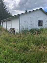
28301 112Th St E
Seattle-Tacoma-Bellevue, WA
Pierce County Short Plat Number 86072903
061904-7005
SECTION 04 TOWNSHIP 19 RANGE 06 QUARTER 34 : L 2 OF SHORT PLAT 86-07-29-0316 TOG/W EASE & RESTRICTIONS OF REC OUT OF 3-006 SEG X-0846 PP ES
Commercialacreage
Pierce
X
Washington
53033C1520G
2
2024
1.79 AC
2025
E Pierce County
070207
Seattle/Puget Sound
768 SF
DEMOGRAPHICS near 28301 112Th St E
1 Mile
3 Mile
5 Mile
2024 Total Population
1,205
10,917
43,417
2029 Population
1,217
11,071
44,413
Pop Growth 2024-2029
+ 1.00%
+ 1.41%
+ 2.29%
Average Age
41
40
40
2024 Total Households
453
3,907
15,718
HH Growth 2024-2029
+ 0.88%
+ 1.36%
+ 2.14%
Median Household Inc
$105,696
$116,905
$110,854
Avg Household Size
2.60
2.70
2.70
2024 Avg HH Vehicles
2.00
3.00
3.00
Median Home Value
$487,999
$491,069
$492,326
Median Year Built
1978
1987
1989
Nearby Places
Map Layers
Map Styles
 Street
 Aerial
- Restaurants
- Banks
- Shops
- Fitness
- Groceries
PUBLIC TRANSPORTATION
AIRPORT
Seattle-Tacoma International
DRIVE
WALK
Distance
Seattle-Tacoma International
50 min
32.1 mi
Freight Ports
Port of Tacoma
DRIVE
WALK
Distance
Port of Tacoma
33 min
21.2 mi
SALE & LEASE HISTORY
LISTING DATE
SALE/LEASE

Jul 09, 2019
For Sale
Nearby Properties
Address
Land Use
TOTAL SIZE
Lot Size
Zoning
Address
Land Use
TOTAL SIZE
Lot Size
Zoning
230,000 SF
54.30 AC
R10
Address
Land Use
TOTAL SIZE
Lot Size
Zoning
240,262 SF
47.07 AC
P
Address
Land Use
TOTAL SIZE
Lot Size
Zoning
44,380 SF
253.26 AC
P
Address
Land Use
TOTAL SIZE
Lot Size
Zoning
47,375 SF
40.51 AC
P
Address
Land Use
TOTAL SIZE
Lot Size
Zoning
151,202 SF
7.94 AC
CG
Address
Land Use
TOTAL SIZE
Lot Size
Zoning
2 SF
10.93 AC
NO DATA
Address
Land Use
TOTAL SIZE
Lot Size
Zoning
87,334 SF
33.88 AC
P
Address
Land Use
TOTAL SIZE
Lot Size
Zoning
45,102 SF
19.53 AC
R10
Address
Land Use
TOTAL SIZE
Lot Size
Zoning
47,992 SF
3.49 AC
NMU
Address
Land Use
TOTAL SIZE
Lot Size
Zoning
79,848 SF
5.99 AC
LI
Address
Land Use
TOTAL SIZE
Lot Size
Zoning
48,905 SF
12.26 AC
R10
Address
Land Use
TOTAL SIZE
Lot Size
Zoning
44,013 SF
3.57 AC
CG
Address
Land Use
TOTAL SIZE
Lot Size
Zoning
27,727 SF
9.25 AC
NMU
Address
Land Use
TOTAL SIZE
Lot Size
Zoning
38,000 SF
2.60 AC
LI
Address
Land Use
TOTAL SIZE
Lot Size
Zoning
38,000 SF
2.62 AC
LI
Address
Land Use
TOTAL SIZE
Lot Size
Zoning
30,692 SF
4.58 AC
P
Address
Land Use
TOTAL SIZE
Lot Size
Zoning
20,373 SF
3.65 AC
BUCK
Address
Land Use
TOTAL SIZE
Lot Size
Zoning
16,060 SF
5.01 AC
R-6,000
Address
Land Use
TOTAL SIZE
Lot Size
Zoning
21,504 SF
1.40 AC
HDR
Address
Land Use
TOTAL SIZE
Lot Size
Zoning
40,000 SF
4.02 AC
LI
Address
Land Use
TOTAL SIZE
Lot Size
Zoning
29,446 SF
4.71 AC
R10
Address
Land Use
TOTAL SIZE
Lot Size
Zoning
24,142 SF
7.70 AC
CG
Address
Land Use
TOTAL SIZE
Lot Size
Zoning
1 SF
6.76 AC
R10
Address
Land Use
TOTAL SIZE
Lot Size
Zoning
17.62 AC
NO DATA
Address
Land Use
TOTAL SIZE
Lot Size
Zoning
1 SF
12 AC
P
Address
Land Use
TOTAL SIZE
Lot Size
Zoning
15,255 SF
1.68 AC
CG
Address
Land Use
TOTAL SIZE
Lot Size
Zoning
4,900 SF
64.18 AC
RA10
Address
Land Use
TOTAL SIZE
Lot Size
Zoning
19,592 SF
0.50 AC
CC
Address
Land Use
TOTAL SIZE
Lot Size
Zoning
13,184 SF
1.46 AC
R-6,000
Address
Land Use
TOTAL SIZE
Lot Size
Zoning
16,620 SF
2.48 AC
R-8,000
The World's #1 Commercial Real Estate Marketplace
Connect with us
© 2026 CoStar Group
The information above has been obtained from sources believed reliable. While we do not doubt its accuracy we have not verified it and make no guarantee, warranty or representation about it. It is your responsibility to independently confirm its accuracy and completeness. Any projections, opinions, assumptions, or estimates used are for example only and do not represent the current or future performance of the property. The value of this transaction to you depends on tax and other factors which should be evaluated by your tax, financial, and legal advisors. You and your advisors should conduct a careful, independent investigation of the property to determine to your satisfaction the suitability of the property for your needs.