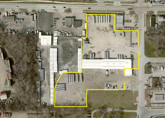
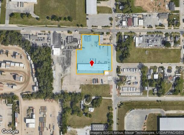
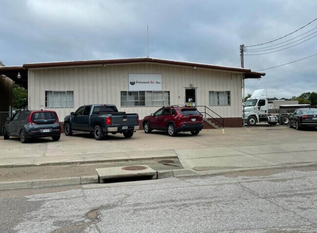
Property Record
2832 N 5Th St, Carter Lake, IA 51510
NEARBY LISTINGS FOR SALE OR LEASE
Property Detail
2832 N 5Th St
Omaha-Council Bluffs, NE-IA
Aud Sub
7544-20-252-011
CARTER LAKE AUD SUB 20-75-44 & ACCRE PT LT 13 & PT VAC S10' LOCUST ST COMM 90'S NE COR LT 10 TH~S250.01' W71.59' S25.77' W277.87' N226.11' E52.48' N160' E174.11' S100.06' E124.18' TO POB (PARCEL~B)
Warehouse
Pottawattamie
X
Iowa
31055C0241H
13
2025
2.53 AC
2025
Northeast Omaha
021200
Omaha/Council Bluffs
DEMOGRAPHICS near 2832 N 5Th St
1 Mile
3 Mile
5 Mile
2024 Total Population
5,676
94,373
228,438
2029 Population
5,768
96,561
231,892
Pop Growth 2024-2029
+ 1.62%
+ 2.32%
+ 1.51%
Average Age
38
36
37
2024 Total Households
2,033
38,377
91,256
HH Growth 2024-2029
+ 1.72%
+ 2.55%
+ 1.66%
Median Household Inc
$45,048
$42,561
$49,184
Avg Household Size
2.60
2.20
2.30
2024 Avg HH Vehicles
2.00
1.00
2.00
Median Home Value
$191,820
$133,658
$152,223
Median Year Built
1975
1955
1952
Nearby Places
Map Layers
Map Styles
 Street
 Aerial
- Restaurants
- Banks
- Shops
- Fitness
- Groceries
PUBLIC TRANSPORTATION
COMMUTER RAIL
Omaha Amtrak Station (California Zephyr - Amtrak)
DRIVE
WALK
Distance
Omaha Amtrak Station (California Zephyr - Amtrak)
8 min
2.9 mi
Omaha Amtrak Station (California Zephyr - Amtrak)
DRIVE
WALK
Distance
Omaha Amtrak Station (California Zephyr - Amtrak)
9 min
3.2 mi
AIRPORT
Eppley Airfield
DRIVE
WALK
Distance
Eppley Airfield
6 min
2.2 mi
Freight Ports
Tulsa Port Of Catoosa
DRIVE
WALK
Distance
Tulsa Port Of Catoosa
467 min
420.6 mi
SALE & LEASE HISTORY
LISTING DATE
SALE/LEASE

Oct 01, 2021
For Lease
Nearby Properties
Address
Land Use
TOTAL SIZE
Lot Size
Zoning
Address
Land Use
TOTAL SIZE
Lot Size
Zoning
1,068,760 SF
1.72 AC
Address
Land Use
TOTAL SIZE
Lot Size
Zoning
1,318,852 SF
8.77 AC
Address
Land Use
TOTAL SIZE
Lot Size
Zoning
603,518 SF
5.55 AC
CBD
Address
Land Use
TOTAL SIZE
Lot Size
Zoning
36.26 AC
P-C
Address
Land Use
TOTAL SIZE
Lot Size
Zoning
534,110 SF
4.35 AC
Address
Land Use
TOTAL SIZE
Lot Size
Zoning
30.39 AC
P-C
Address
Land Use
TOTAL SIZE
Lot Size
Zoning
362,402 SF
1.94 AC
Address
Land Use
TOTAL SIZE
Lot Size
Zoning
318,811 SF
11.51 AC
Address
Land Use
TOTAL SIZE
Lot Size
Zoning
254,306 SF
0.82 AC
Address
Land Use
TOTAL SIZE
Lot Size
Zoning
426,416 SF
1.55 AC
Address
Land Use
TOTAL SIZE
Lot Size
Zoning
1,027,620 SF
4.33 AC
Address
Land Use
TOTAL SIZE
Lot Size
Zoning
378,420 SF
0.72 AC
Address
Land Use
TOTAL SIZE
Lot Size
Zoning
276,622 SF
3.90 AC
Address
Land Use
TOTAL SIZE
Lot Size
Zoning
189,720 SF
1.22 AC
CBD
Address
Land Use
TOTAL SIZE
Lot Size
Zoning
346,816 SF
0.80 AC
Address
Land Use
TOTAL SIZE
Lot Size
Zoning
318,392 SF
7.77 AC
Address
Land Use
TOTAL SIZE
Lot Size
Zoning
4.22 AC
R-4
Address
Land Use
TOTAL SIZE
Lot Size
Zoning
319,440 SF
3.05 AC
Address
Land Use
TOTAL SIZE
Lot Size
Zoning
206,591 SF
0.60 AC
Address
Land Use
TOTAL SIZE
Lot Size
Zoning
335,431 SF
0.79 AC
Address
Land Use
TOTAL SIZE
Lot Size
Zoning
10.91 AC
R-3
Address
Land Use
TOTAL SIZE
Lot Size
Zoning
140,130 SF
1.89 AC
Address
Land Use
TOTAL SIZE
Lot Size
Zoning
149,737 SF
1.93 AC
Address
Land Use
TOTAL SIZE
Lot Size
Zoning
274,024 SF
1.46 AC
Address
Land Use
TOTAL SIZE
Lot Size
Zoning
254,548 SF
1.67 AC
Address
Land Use
TOTAL SIZE
Lot Size
Zoning
198,447 SF
1.36 AC
Address
Land Use
TOTAL SIZE
Lot Size
Zoning
162,765 SF
0.42 AC
CBD
Address
Land Use
TOTAL SIZE
Lot Size
Zoning
200,501 SF
1.78 AC
DS
The World's #1 Commercial Real Estate Marketplace
Connect with us
© 2025 CoStar Group
The information above has been obtained from sources believed reliable. While we do not doubt its accuracy we have not verified it and make no guarantee, warranty or representation about it. It is your responsibility to independently confirm its accuracy and completeness. Any projections, opinions, assumptions, or estimates used are for example only and do not represent the current or future performance of the property. The value of this transaction to you depends on tax and other factors which should be evaluated by your tax, financial, and legal advisors. You and your advisors should conduct a careful, independent investigation of the property to determine to your satisfaction the suitability of the property for your needs.