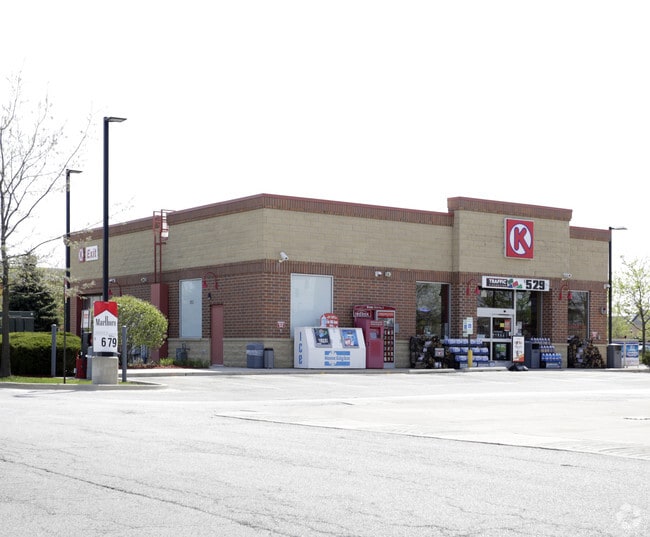
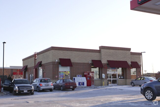
Property Record
2832 S Route 59, Naperville, IL 60564
NEARBY LISTINGS FOR SALE OR LEASE
Property Detail
2832 S Route 59
Chicago-Naperville-Elgin, IL-IN-WI
Commercial
07-01-03-306-001
LOT 2 IN BAILEY SATCHEL'S SUB, BEING A SUB OF PRT OF THE W1/2 OF THE SW1/4 OF SEC. 3, T37N-R9E, (EX THAT PRT TAKEN FOR ROAD
Commercialnec
Will
X
Illinois
17197C0030G
2
2024
0.86 AC
2024
Joliet/Central Will
880307
Chicago
37,287 SF
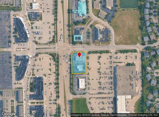
DEMOGRAPHICS near 2832 S Route 59
1 Mile
3 Mile
5 Mile
2024 Total Population
12,032
85,651
222,033
2029 Population
11,929
84,816
221,721
Pop Growth 2024-2029
(0.86%)
(0.97%)
(0.14%)
Average Age
40
37
38
2024 Total Households
4,327
27,760
74,535
HH Growth 2024-2029
(0.74%)
(1.01%)
(0.20%)
Median Household Inc
$131,557
$137,817
$123,801
Avg Household Size
2.70
3.00
2.90
2024 Avg HH Vehicles
2.00
2.00
2.00
Median Home Value
$551,552
$410,108
$364,627
Median Year Built
1998
1995
1994
Nearby Places
Map Layers
Map Styles
 Street
 Aerial
- Restaurants
- Banks
- Shops
- Fitness
- Groceries
PUBLIC TRANSPORTATION
COMMUTER RAIL
Route 59 Station (Burlington Northern-Santa Fe Railway Line - Northeast Illinois Regional Commuter Railroad (Metra))
DRIVE
WALK
Distance
Route 59 Station (Burlington Northern-Santa Fe Railway Line - Northeast Illinois Regional Commuter Railroad (Metra))
11 min
5.4 mi
Naperville Station (Burlington Northern-Santa Fe Railway Line - Northeast Illinois Regional Commuter Railroad (Metra))
DRIVE
WALK
Distance
Naperville Station (Burlington Northern-Santa Fe Railway Line - Northeast Illinois Regional Commuter Railroad (Metra))
16 min
7.8 mi
AIRPORT
Chicago Midway International
DRIVE
WALK
Distance
Chicago Midway International
45 min
27.6 mi
Chicago O'Hare International
DRIVE
WALK
Distance
Chicago O'Hare International
53 min
35.4 mi
Freight Ports
Port Milwaukee
DRIVE
WALK
Distance
Port Milwaukee
134 min
107.1 mi
Nearby Properties
Address
Land Use
TOTAL SIZE
Lot Size
Zoning
Address
Land Use
TOTAL SIZE
Lot Size
Zoning
916,143 SF
32.66 AC
Address
Land Use
TOTAL SIZE
Lot Size
Zoning
19.92 AC
C
Address
Land Use
TOTAL SIZE
Lot Size
Zoning
22.35 AC
Address
Land Use
TOTAL SIZE
Lot Size
Zoning
24.91 AC
Address
Land Use
TOTAL SIZE
Lot Size
Zoning
13.71 AC
Address
Land Use
TOTAL SIZE
Lot Size
Zoning
11.02 AC
M
Address
Land Use
TOTAL SIZE
Lot Size
Zoning
9.83 AC
C
Address
Land Use
TOTAL SIZE
Lot Size
Zoning
10 AC
C
Address
Land Use
TOTAL SIZE
Lot Size
Zoning
342,257 SF
31.05 AC
C
Address
Land Use
TOTAL SIZE
Lot Size
Zoning
133,779 SF
9.77 AC
C
Address
Land Use
TOTAL SIZE
Lot Size
Zoning
252,909 SF
5.81 AC
Address
Land Use
TOTAL SIZE
Lot Size
Zoning
189,289 SF
18.56 AC
Address
Land Use
TOTAL SIZE
Lot Size
Zoning
242,949 SF
26.73 AC
C
Address
Land Use
TOTAL SIZE
Lot Size
Zoning
155,459 SF
16.81 AC
C
Address
Land Use
TOTAL SIZE
Lot Size
Zoning
338,220 SF
37.91 AC
C
Address
Land Use
TOTAL SIZE
Lot Size
Zoning
250,712 SF
10.60 AC
I
Address
Land Use
TOTAL SIZE
Lot Size
Zoning
6.31 AC
M
Address
Land Use
TOTAL SIZE
Lot Size
Zoning
416,129 SF
9.55 AC
Address
Land Use
TOTAL SIZE
Lot Size
Zoning
53,644 SF
6.29 AC
C
Address
Land Use
TOTAL SIZE
Lot Size
Zoning
72,141 SF
12.13 AC
Address
Land Use
TOTAL SIZE
Lot Size
Zoning
409,695 SF
9.41 AC
Address
Land Use
TOTAL SIZE
Lot Size
Zoning
91,256 SF
3.03 AC
Address
Land Use
TOTAL SIZE
Lot Size
Zoning
12.44 AC
Address
Land Use
TOTAL SIZE
Lot Size
Zoning
3.46 AC
M
Address
Land Use
TOTAL SIZE
Lot Size
Zoning
120,950 SF
5.74 AC
I
Address
Land Use
TOTAL SIZE
Lot Size
Zoning
47,641 SF
4.52 AC
C
Address
Land Use
TOTAL SIZE
Lot Size
Zoning
39,306 SF
7.80 AC
C
Address
Land Use
TOTAL SIZE
Lot Size
Zoning
445,837 SF
10.24 AC
Address
Land Use
TOTAL SIZE
Lot Size
Zoning
406,938 SF
9.34 AC
Address
Land Use
TOTAL SIZE
Lot Size
Zoning
50,931 SF
3.79 AC
C
The World's #1 Commercial Real Estate Marketplace
Connect with us
© 2025 CoStar Group
The information above has been obtained from sources believed reliable. While we do not doubt its accuracy we have not verified it and make no guarantee, warranty or representation about it. It is your responsibility to independently confirm its accuracy and completeness. Any projections, opinions, assumptions, or estimates used are for example only and do not represent the current or future performance of the property. The value of this transaction to you depends on tax and other factors which should be evaluated by your tax, financial, and legal advisors. You and your advisors should conduct a careful, independent investigation of the property to determine to your satisfaction the suitability of the property for your needs.