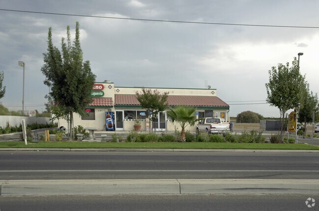
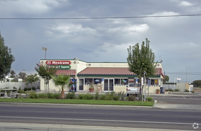
Property Record
2833 E Manning Ave, Fowler, CA 93625


Current Lease Availabilities
Property Detail
2833 E Manning Ave
345-180-18
1.94 AC LYG S & W OF STATE HWY SEC 23 T15R21
Restaurantbuilding
Fresno
C3
California
B and X Area of moderate flood hazard, usually the area between the limits of the 100-year and 500-year floods.
1.94 AC
2025
Fowler/Selma
2025
Fresno
001700
Fresno, CA
3,116 SF
NEARBY LISTINGS FOR SALE OR LEASE
DEMOGRAPHICS near 2833 E Manning Ave
1 mile
3 mile
5 mile
2025 Total Population
340
17,938
40,020
2030 Population
348
18,201
40,448
Pop Growth 2025-2030
+ 2.35%
+ 1.47%
+ 1.07%
Average Age
37
37
36
2025 Total Households
102
5,267
11,553
HH Growth 2025-2030
+ 1.96%
+ 1.44%
+ 1.01%
Median Household Inc
$68,249
$61,544
$57,896
Avg Household Size
3.40
3.40
3.40
2025 Avg HH Vehicles
2.00
2.00
2.00
Median Home Value
$427,272
$358,926
$357,854
Median Year Built
1986
1982
1980
Nearby Places
Map Layers
Map Styles
 Street
 Aerial
Transit
 Traffic
 Biking
Places
Listings with unknown addresses are not visible on the map
- Restaurants
- Banks
- Shops
- Fitness
- Groceries
PUBLIC TRANSPORTATION
AIRPORT
Fresno Yosemite International
Drive
Walk
Distance
Fresno Yosemite International
22 min
13.8 mi
Freight Ports
Port of Stockton
Drive
Walk
Distance
Port of Stockton
162 min
138.9 mi
Nearby Properties
Address
Land Use
TOTAL SIZE
Lot Size
Zoning
Address
Land Use
TOTAL SIZE
Lot Size
Zoning
725,468 SF
25 AC
MI
Address
Land Use
TOTAL SIZE
Lot Size
Zoning
242,970 SF
30.43 AC
Address
Land Use
TOTAL SIZE
Lot Size
Zoning
270,292 SF
23.86 AC
M1
Address
Land Use
TOTAL SIZE
Lot Size
Zoning
272,338 SF
25.80 AC
M2
Address
Land Use
TOTAL SIZE
Lot Size
Zoning
104,516 SF
11.30 AC
C3*TWR
Address
Land Use
TOTAL SIZE
Lot Size
Zoning
106,112 SF
12.78 AC
AE20
Address
Land Use
TOTAL SIZE
Lot Size
Zoning
166,390 SF
32.58 AC
M3
Address
Land Use
TOTAL SIZE
Lot Size
Zoning
52,725 SF
2.04 AC
CR
Address
Land Use
TOTAL SIZE
Lot Size
Zoning
58,560 SF
6.46 AC
C3P
Address
Land Use
TOTAL SIZE
Lot Size
Zoning
48,639 SF
6.50 AC
CR
Address
Land Use
TOTAL SIZE
Lot Size
Zoning
37,081 SF
4.40 AC
C2
Address
Land Use
TOTAL SIZE
Lot Size
Zoning
140,609 SF
84.02 AC
M2
Address
Land Use
TOTAL SIZE
Lot Size
Zoning
67,162 SF
3.91 AC
RM3
Address
Land Use
TOTAL SIZE
Lot Size
Zoning
195,223 SF
10.66 AC
M3
Address
Land Use
TOTAL SIZE
Lot Size
Zoning
58,473 SF
0.77 AC
C3
Address
Land Use
TOTAL SIZE
Lot Size
Zoning
127,130 SF
9.78 AC
AE20
Address
Land Use
TOTAL SIZE
Lot Size
Zoning
246,464 SF
39.73 AC
M3
Address
Land Use
TOTAL SIZE
Lot Size
Zoning
10,800 SF
1.52 AC
CZP
Address
Land Use
TOTAL SIZE
Lot Size
Zoning
41,400 SF
0.97 AC
CH
Address
Land Use
TOTAL SIZE
Lot Size
Zoning
62,534 SF
12.45 AC
C3
Address
Land Use
TOTAL SIZE
Lot Size
Zoning
21,510 SF
2.92 AC
C2
Address
Land Use
TOTAL SIZE
Lot Size
Zoning
51,886 SF
3.35 AC
C2
Address
Land Use
TOTAL SIZE
Lot Size
Zoning
14,550 SF
1.68 AC
C3
Address
Land Use
TOTAL SIZE
Lot Size
Zoning
17,780 SF
1.25 AC
C3
Address
Land Use
TOTAL SIZE
Lot Size
Zoning
17,500 SF
3.86 AC
C3
Address
Land Use
TOTAL SIZE
Lot Size
Zoning
2,131 SF
148.88 AC
AE20
Address
Land Use
TOTAL SIZE
Lot Size
Zoning
35,504 SF
3.77 AC
C3
Address
Land Use
TOTAL SIZE
Lot Size
Zoning
172,176 SF
12.11 AC
M3
The World's #1 Commercial Real Estate Marketplace
Connect with us
© 2026 CoStar Group
The information above has been obtained from sources believed reliable. While we do not doubt its accuracy we have not verified it and make no guarantee, warranty or representation about it. It is your responsibility to independently confirm its accuracy and completeness. Any projections, opinions, assumptions, or estimates used are for example only and do not represent the current or future performance of the property. The value of this transaction to you depends on tax and other factors which should be evaluated by your tax, financial, and legal advisors. You and your advisors should conduct a careful, independent investigation of the property to determine to your satisfaction the suitability of the property for your needs.