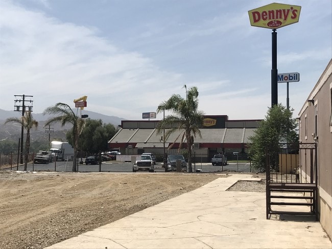
Property Record
28368 Sand Canyon Rd, Canyon Country, CA 91387

NEARBY LISTINGS FOR SALE OR LEASE
Property Detail
28368 Sand Canyon Rd
2840-008-031
FOR DESC SEE ASSESSORS MAPS*POR OF NE 1/4 OF SEC 23 T 4N R 15W
Restaurantdrivein
Los Angeles
AE
California
06037C0845G
23
2024
1.24 AC
2025
Santa Clarita Valley
910809
Los Angeles
2,930 SF
Los Angeles-Long Beach-Glendale, CA
DEMOGRAPHICS near 28368 Sand Canyon Rd
1 Mile
3 Mile
5 Mile
2024 Total Population
7,376
60,190
101,730
2029 Population
6,957
57,975
97,896
Pop Growth 2024-2029
(5.68%)
(3.68%)
(3.77%)
Average Age
38
38
39
2024 Total Households
2,235
19,046
32,835
HH Growth 2024-2029
(5.86%)
(3.95%)
(3.93%)
Median Household Inc
$116,952
$97,253
$101,044
Avg Household Size
3.20
3.10
3.00
2024 Avg HH Vehicles
3.00
2.00
2.00
Median Home Value
$721,087
$668,235
$671,424
Median Year Built
1986
1987
1987
Nearby Places
Map Layers
Map Styles
 Street
 Aerial
- Restaurants
- Banks
- Shops
- Fitness
- Groceries
PUBLIC TRANSPORTATION
COMMUTER RAIL
DRIVE
WALK
Distance
4 min
1.3 mi
Via Princessa (Antelope Valley Line - Southern California Regional Rail Authority (Metrolink))
DRIVE
WALK
Distance
Via Princessa (Antelope Valley Line - Southern California Regional Rail Authority (Metrolink))
7 min
4.0 mi
AIRPORT
Bob Hope
DRIVE
WALK
Distance
Bob Hope
30 min
22.5 mi
Los Angeles International
DRIVE
WALK
Distance
Los Angeles International
51 min
39.6 mi
Freight Ports
Port of Long Beach
DRIVE
WALK
Distance
Port of Long Beach
73 min
59.1 mi
SALE & LEASE HISTORY
LISTING DATE
SALE/LEASE

Mar 04, 2020
For Lease
Feb 27, 2019
For Lease
Aug 22, 2018
For Lease
Nearby Properties
Address
Land Use
TOTAL SIZE
Lot Size
Zoning
Address
Land Use
TOTAL SIZE
Lot Size
Zoning
163,685 SF
9.83 AC
SCSP
Address
Land Use
TOTAL SIZE
Lot Size
Zoning
255,744 SF
8.33 AC
SCUR3
Address
Land Use
TOTAL SIZE
Lot Size
Zoning
147,856 SF
2.96 AC
SCSP
Address
Land Use
TOTAL SIZE
Lot Size
Zoning
97,780 SF
14.98 AC
SCUR3
Address
Land Use
TOTAL SIZE
Lot Size
Zoning
272,382 SF
35.44 AC
SCUR5
Address
Land Use
TOTAL SIZE
Lot Size
Zoning
241,112 SF
10.98 AC
SCUR5
Address
Land Use
TOTAL SIZE
Lot Size
Zoning
137,834 SF
8.78 AC
SCSP
Address
Land Use
TOTAL SIZE
Lot Size
Zoning
74,176 SF
6.89 AC
SCUR3
Address
Land Use
TOTAL SIZE
Lot Size
Zoning
347,378 SF
14.11 AC
SCCP
Address
Land Use
TOTAL SIZE
Lot Size
Zoning
134,837 SF
12.52 AC
SCCR
Address
Land Use
TOTAL SIZE
Lot Size
Zoning
235,426 SF
5.50 AC
SCSP
Address
Land Use
TOTAL SIZE
Lot Size
Zoning
169,848 SF
9 AC
SCSP
Address
Land Use
TOTAL SIZE
Lot Size
Zoning
70,408 SF
8.69 AC
SCCP
Address
Land Use
TOTAL SIZE
Lot Size
Zoning
151,452 SF
5.63 AC
SCUR5
Address
Land Use
TOTAL SIZE
Lot Size
Zoning
144,240 SF
5.51 AC
SCUR5
Address
Land Use
TOTAL SIZE
Lot Size
Zoning
53,342 SF
1.37 AC
SCCC
Address
Land Use
TOTAL SIZE
Lot Size
Zoning
50,908 SF
1.42 AC
SCSP
Address
Land Use
TOTAL SIZE
Lot Size
Zoning
137,018 SF
5.52 AC
SCUR5
Address
Land Use
TOTAL SIZE
Lot Size
Zoning
55,719 SF
0.61 AC
SCSP
Address
Land Use
TOTAL SIZE
Lot Size
Zoning
37,260 SF
0.97 AC
SCCC
Address
Land Use
TOTAL SIZE
Lot Size
Zoning
120,186 SF
12.31 AC
SCCC
Address
Land Use
TOTAL SIZE
Lot Size
Zoning
115,392 SF
4.75 AC
SCUR5
Address
Land Use
TOTAL SIZE
Lot Size
Zoning
38,308 SF
2.04 AC
SCCC
Address
Land Use
TOTAL SIZE
Lot Size
Zoning
149,166 SF
5.64 AC
SCUR5
Address
Land Use
TOTAL SIZE
Lot Size
Zoning
100,968 SF
3.65 AC
SCUR5
Address
Land Use
TOTAL SIZE
Lot Size
Zoning
136,971 SF
5.35 AC
SCUR5
Address
Land Use
TOTAL SIZE
Lot Size
Zoning
60,252 SF
2.20 AC
SCUR5
Address
Land Use
TOTAL SIZE
Lot Size
Zoning
60,252 SF
2.39 AC
SCUR5
Address
Land Use
TOTAL SIZE
Lot Size
Zoning
126,676 SF
3.37 AC
SCSP
Address
Land Use
TOTAL SIZE
Lot Size
Zoning
25,382 SF
2.24 AC
SCCC
The World's #1 Commercial Real Estate Marketplace
Connect with us
© 2026 CoStar Group
The information above has been obtained from sources believed reliable. While we do not doubt its accuracy we have not verified it and make no guarantee, warranty or representation about it. It is your responsibility to independently confirm its accuracy and completeness. Any projections, opinions, assumptions, or estimates used are for example only and do not represent the current or future performance of the property. The value of this transaction to you depends on tax and other factors which should be evaluated by your tax, financial, and legal advisors. You and your advisors should conduct a careful, independent investigation of the property to determine to your satisfaction the suitability of the property for your needs.