Property Record
2837 Scruggs Rd, Moneta, VA 24121

Current Lease Availabilities
NEARBY LISTINGS FOR SALE OR LEASE
Property Detail
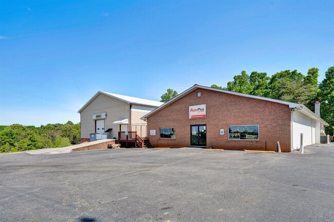
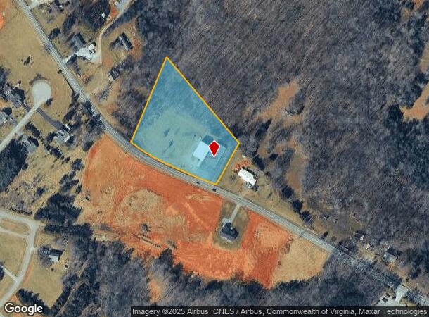
2837 Scruggs Rd
0330002101
Park Ridge West
Storebuilding
ROAD 616
X
Franklin
51019C0550D
Virginia
2024
2.97 AC
2024
North Franklin County
020104
Roanoke
4,800 SF
Roanoke, VA
DEMOGRAPHICS near 2837 Scruggs Rd
1 Mile
3 Mile
5 Mile
2024 Total Population
431
4,794
13,340
2029 Population
456
5,112
14,243
Pop Growth 2024-2029
+ 5.80%
+ 6.63%
+ 6.77%
Average Age
49
53
52
2024 Total Households
181
2,196
6,052
HH Growth 2024-2029
+ 6.08%
+ 6.65%
+ 6.79%
Median Household Inc
$84,895
$90,925
$86,576
Avg Household Size
2.10
2.10
2.10
2024 Avg HH Vehicles
2.00
2.00
2.00
Median Home Value
$411,538
$461,572
$458,996
Median Year Built
1990
1988
1991
Nearby Places
Map Layers
Map Styles
 Street
 Aerial
- Restaurants
- Banks
- Shops
- Fitness
- Groceries
PUBLIC TRANSPORTATION
AIRPORT
Roanoke/Blacksburg Regional (Woodrum Field)
DRIVE
WALK
Distance
Roanoke/Blacksburg Regional (Woodrum Field)
48 min
30.7 mi
Lynchburg Regional/Preston Glenn Field
DRIVE
WALK
Distance
Lynchburg Regional/Preston Glenn Field
63 min
42.9 mi
Nearby Properties
Address
Land Use
TOTAL SIZE
Lot Size
Zoning
Address
Land Use
TOTAL SIZE
Lot Size
Zoning
37,702 SF
3.90 AC
PCD
Address
Land Use
TOTAL SIZE
Lot Size
Zoning
40,454 SF
16.22 AC
SM
Address
Land Use
TOTAL SIZE
Lot Size
Zoning
69,458 SF
5.12 AC
PCD
Address
Land Use
TOTAL SIZE
Lot Size
Zoning
588.45 AC
SM
Address
Land Use
TOTAL SIZE
Lot Size
Zoning
46,034 SF
5.99 AC
PCD
Address
Land Use
TOTAL SIZE
Lot Size
Zoning
41,054 SF
12.91 AC
B2
Address
Land Use
TOTAL SIZE
Lot Size
Zoning
18,044 SF
2.63 AC
PCD
Address
Land Use
TOTAL SIZE
Lot Size
Zoning
43,707 SF
4.37 AC
B2
Address
Land Use
TOTAL SIZE
Lot Size
Zoning
10,272 SF
19.60 AC
PCD
Address
Land Use
TOTAL SIZE
Lot Size
Zoning
15,000 SF
7.72 AC
B2
Address
Land Use
TOTAL SIZE
Lot Size
Zoning
56.62 AC
PCD
Address
Land Use
TOTAL SIZE
Lot Size
Zoning
21,360 SF
3.76 AC
PCD
Address
Land Use
TOTAL SIZE
Lot Size
Zoning
45,064 SF
3.02 AC
PCD
Address
Land Use
TOTAL SIZE
Lot Size
Zoning
11,016 SF
1.73 AC
B2
Address
Land Use
TOTAL SIZE
Lot Size
Zoning
19,676 SF
4.01 AC
PCD
Address
Land Use
TOTAL SIZE
Lot Size
Zoning
21,120 SF
1.55 AC
B2
Address
Land Use
TOTAL SIZE
Lot Size
Zoning
57,250 SF
19.63 AC
B2
Address
Land Use
TOTAL SIZE
Lot Size
Zoning
19,102 SF
1.44 AC
B2
Address
Land Use
TOTAL SIZE
Lot Size
Zoning
8,860 SF
3.67 AC
B2
Address
Land Use
TOTAL SIZE
Lot Size
Zoning
13,830 SF
106 AC
RPD
Address
Land Use
TOTAL SIZE
Lot Size
Zoning
4,450 SF
5.76 AC
RPD
Address
Land Use
TOTAL SIZE
Lot Size
Zoning
2,948 SF
1.84 AC
B2
Address
Land Use
TOTAL SIZE
Lot Size
Zoning
17,300 SF
1.42 AC
B2
Address
Land Use
TOTAL SIZE
Lot Size
Zoning
3,750 SF
1.08 AC
PCD
Address
Land Use
TOTAL SIZE
Lot Size
Zoning
4,708 SF
1.16 AC
B2
Address
Land Use
TOTAL SIZE
Lot Size
Zoning
6,300 SF
4.86 AC
B2
Address
Land Use
TOTAL SIZE
Lot Size
Zoning
5,154 SF
5 AC
A1
Address
Land Use
TOTAL SIZE
Lot Size
Zoning
29.16 AC
B2
Address
Land Use
TOTAL SIZE
Lot Size
Zoning
6,091 SF
1.70 AC
B2
The World's #1 Commercial Real Estate Marketplace
Connect with us
© 2026 CoStar Group
The information above has been obtained from sources believed reliable. While we do not doubt its accuracy we have not verified it and make no guarantee, warranty or representation about it. It is your responsibility to independently confirm its accuracy and completeness. Any projections, opinions, assumptions, or estimates used are for example only and do not represent the current or future performance of the property. The value of this transaction to you depends on tax and other factors which should be evaluated by your tax, financial, and legal advisors. You and your advisors should conduct a careful, independent investigation of the property to determine to your satisfaction the suitability of the property for your needs.