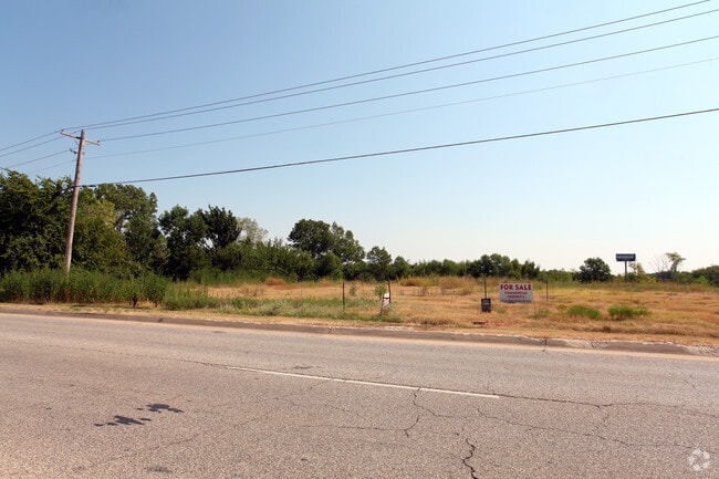
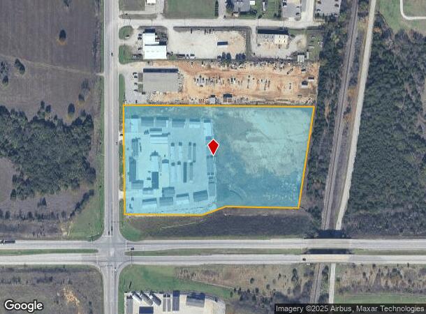
Property Record
2838 S Commerce St, Ardmore, OK 73401
NEARBY LISTINGS FOR SALE OR LEASE
-
-
View all Ardmore listings for sale on LoopNet.com
Property Detail
2838 S Commerce St
Ardmore, OK
Ardmore City Tracts
1990-07-05S-02E-2-002-00
A TRACT OF LAND LYING W/2 NW: FROM SW/C OF SAID W/2 NW; N89.5553E 50; N00.3629W 1180 TO POB; N00.3629W 509.14; N89.5659E 889.07; S7.4057W 478.84; S89.3730W 348.54; S78.1930W 153; S89.3730W 321.20 TO POB- 07 05S 02E
Farmsupplyequipmentretail
Carter
X
Oklahoma
40019C0445C
2e
2024
9.62 AC
2025
Oklahoma East Area
893100
Other Market Areas
1,200 SF
DEMOGRAPHICS near 2838 S Commerce St
1 Mile
3 Mile
5 Mile
2024 Total Population
458
15,781
29,075
2029 Population
469
16,288
29,963
Pop Growth 2024-2029
+ 2.40%
+ 3.21%
+ 3.05%
Average Age
40
40
41
2024 Total Households
164
6,187
11,568
HH Growth 2024-2029
+ 3.05%
+ 3.20%
+ 3.03%
Median Household Inc
$68,942
$46,542
$49,567
Avg Household Size
2.70
2.40
2.40
2024 Avg HH Vehicles
2.00
2.00
2.00
Median Home Value
$211,364
$145,244
$149,095
Median Year Built
1979
1965
1971
Nearby Places
Map Layers
Map Styles
 Street
 Aerial
- Restaurants
- Banks
- Shops
- Fitness
- Groceries
PUBLIC TRANSPORTATION
COMMUTER RAIL
Ardmore Amtrak Station (Heartland Flyer - Amtrak)
DRIVE
WALK
Distance
Ardmore Amtrak Station (Heartland Flyer - Amtrak)
6 min
3.6 mi
Freight Ports
Tulsa Port of Inola
DRIVE
WALK
Distance
Tulsa Port of Inola
240 min
207.6 mi
Nearby Properties
Address
Land Use
TOTAL SIZE
Lot Size
Zoning
Address
Land Use
TOTAL SIZE
Lot Size
Zoning
1,020 SF
34.64 AC
C1
Address
Land Use
TOTAL SIZE
Lot Size
Zoning
828 SF
12.24 AC
C1
Address
Land Use
TOTAL SIZE
Lot Size
Zoning
3,188 SF
2.75 AC
C1
Address
Land Use
TOTAL SIZE
Lot Size
Zoning
1,479 SF
2.33 AC
C1
Address
Land Use
TOTAL SIZE
Lot Size
Zoning
7,560 SF
7.26 AC
C1
Address
Land Use
TOTAL SIZE
Lot Size
Zoning
3,078 SF
1.53 AC
C1
Address
Land Use
TOTAL SIZE
Lot Size
Zoning
11,664 SF
11.46 AC
C1
Address
Land Use
TOTAL SIZE
Lot Size
Zoning
5,889 SF
2.62 AC
C1
Address
Land Use
TOTAL SIZE
Lot Size
Zoning
3,150 SF
0.92 AC
C1
Address
Land Use
TOTAL SIZE
Lot Size
Zoning
23,980 SF
16.77 AC
Address
Land Use
TOTAL SIZE
Lot Size
Zoning
7,168 SF
2.40 AC
C1
Address
Land Use
TOTAL SIZE
Lot Size
Zoning
36,800 SF
1.10 AC
C1
Address
Land Use
TOTAL SIZE
Lot Size
Zoning
444 SF
12.92 AC
C1
Address
Land Use
TOTAL SIZE
Lot Size
Zoning
3,294 SF
5.38 AC
C1
Address
Land Use
TOTAL SIZE
Lot Size
Zoning
3,125 SF
10 AC
C1
Address
Land Use
TOTAL SIZE
Lot Size
Zoning
1,000 SF
1.63 AC
C1
Address
Land Use
TOTAL SIZE
Lot Size
Zoning
6,118 SF
1.80 AC
C1
Address
Land Use
TOTAL SIZE
Lot Size
Zoning
2,500 SF
10 AC
C1
Address
Land Use
TOTAL SIZE
Lot Size
Zoning
8,099 SF
0.82 AC
C1
Address
Land Use
TOTAL SIZE
Lot Size
Zoning
3,800 SF
8.06 AC
C1
Address
Land Use
TOTAL SIZE
Lot Size
Zoning
6,664 SF
0.15 AC
C1
Address
Land Use
TOTAL SIZE
Lot Size
Zoning
5,588 SF
7.25 AC
C1
Address
Land Use
TOTAL SIZE
Lot Size
Zoning
4,073 SF
2.84 AC
C1
Address
Land Use
TOTAL SIZE
Lot Size
Zoning
3,985 SF
10 AC
C1
Address
Land Use
TOTAL SIZE
Lot Size
Zoning
336 SF
0.34 AC
C1
Address
Land Use
TOTAL SIZE
Lot Size
Zoning
5,840 SF
0.41 AC
C1
Address
Land Use
TOTAL SIZE
Lot Size
Zoning
55,440 SF
10.01 AC
C1
Address
Land Use
TOTAL SIZE
Lot Size
Zoning
2,300 SF
2.16 AC
C1
Address
Land Use
TOTAL SIZE
Lot Size
Zoning
3,972 SF
1.13 AC
C1
Address
Land Use
TOTAL SIZE
Lot Size
Zoning
2,282 SF
5 AC
R1
The World's #1 Commercial Real Estate Marketplace
Connect with us
© 2025 CoStar Group
The information above has been obtained from sources believed reliable. While we do not doubt its accuracy we have not verified it and make no guarantee, warranty or representation about it. It is your responsibility to independently confirm its accuracy and completeness. Any projections, opinions, assumptions, or estimates used are for example only and do not represent the current or future performance of the property. The value of this transaction to you depends on tax and other factors which should be evaluated by your tax, financial, and legal advisors. You and your advisors should conduct a careful, independent investigation of the property to determine to your satisfaction the suitability of the property for your needs.