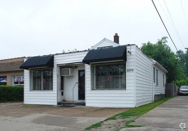
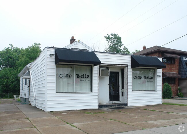
Property Record
2839 Elmwood Ave, Buffalo, NY 14217
NEARBY LISTINGS FOR SALE OR LEASE
Property Detail
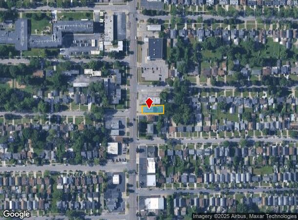
2839 Elmwood Ave
Buffalo-Cheektowaga-Niagara Falls, NY
Holland Land Companys Survey
146489-066-530-0004-019-000
146 N TULANE RD 1200 57 PT 58 45 X 127
Storesoffices
Erie
X
New York
36029C0182H
19.000
2025
0.13 AC
2024
North
008202
Buffalo/Niagara Falls
1,620 SF
DEMOGRAPHICS near 2839 Elmwood Ave
1 Mile
3 Mile
5 Mile
2024 Total Population
19,251
128,001
309,527
2029 Population
18,951
125,583
304,384
Pop Growth 2024-2029
(1.56%)
(1.89%)
(1.66%)
Average Age
42
40
39
2024 Total Households
8,876
57,160
132,600
HH Growth 2024-2029
(1.67%)
(1.95%)
(1.71%)
Median Household Inc
$61,810
$59,223
$55,613
Avg Household Size
2.10
2.20
2.20
2024 Avg HH Vehicles
1.00
1.00
1.00
Median Home Value
$165,923
$166,321
$174,469
Median Year Built
1948
1949
1948
Nearby Places
- Restaurants
- Banks
- Shops
- Fitness
- Groceries
PUBLIC TRANSPORTATION
COMMUTER RAIL
DRIVE
WALK
Distance
18 min
9.0 mi
AIRPORT
Buffalo Niagara International
DRIVE
WALK
Distance
Buffalo Niagara International
20 min
9.8 mi
Niagara Falls International
DRIVE
WALK
Distance
Niagara Falls International
22 min
10.9 mi
SALE & LEASE HISTORY
LISTING DATE
SALE/LEASE

Sep 24, 2016
For Sale
Feb 24, 2017
For Sale
Nearby Properties
Address
Land Use
TOTAL SIZE
Lot Size
Zoning
Address
Land Use
TOTAL SIZE
Lot Size
Zoning
139,224 SF
13.72 AC
WID
Address
Land Use
TOTAL SIZE
Lot Size
Zoning
80,927 SF
28.20 AC
WID
Address
Land Use
TOTAL SIZE
Lot Size
Zoning
121,015 SF
92.60 AC
D-E
Address
Land Use
TOTAL SIZE
Lot Size
Zoning
239,735 SF
17.73 AC
TND
Address
Land Use
TOTAL SIZE
Lot Size
Zoning
100,737 SF
21.10 AC
CTR-5
Address
Land Use
TOTAL SIZE
Lot Size
Zoning
94,680 SF
175.90 AC
D-OG
Address
Land Use
TOTAL SIZE
Lot Size
Zoning
3,456 SF
6.90 AC
MFR-5
Address
Land Use
TOTAL SIZE
Lot Size
Zoning
650,000 SF
42.15 AC
G-1
Address
Land Use
TOTAL SIZE
Lot Size
Zoning
61,327 SF
175 AC
D-OG
Address
Land Use
TOTAL SIZE
Lot Size
Zoning
67,666 SF
17.43 AC
G-1
Address
Land Use
TOTAL SIZE
Lot Size
Zoning
3.20 AC
G-1
Address
Land Use
TOTAL SIZE
Lot Size
Zoning
11,808 SF
11.93 AC
N-3R
Address
Land Use
TOTAL SIZE
Lot Size
Zoning
2,474 SF
24.84 AC
Address
Land Use
TOTAL SIZE
Lot Size
Zoning
120,954 SF
9.74 AC
D-S
Address
Land Use
TOTAL SIZE
Lot Size
Zoning
6,862 SF
14.28 AC
CTR-5
Address
Land Use
TOTAL SIZE
Lot Size
Zoning
356,891 SF
21.33 AC
B
Address
Land Use
TOTAL SIZE
Lot Size
Zoning
16 AC
G-1
Address
Land Use
TOTAL SIZE
Lot Size
Zoning
151,641 SF
1.53 AC
N-1S
Address
Land Use
TOTAL SIZE
Lot Size
Zoning
107,490 SF
3.55 AC
Address
Land Use
TOTAL SIZE
Lot Size
Zoning
33,970 SF
9.70 AC
Address
Land Use
TOTAL SIZE
Lot Size
Zoning
135,140 SF
25.60 AC
Address
Land Use
TOTAL SIZE
Lot Size
Zoning
138,000 SF
7.30 AC
P-S
Address
Land Use
TOTAL SIZE
Lot Size
Zoning
97,298 SF
15.28 AC
D-S
Address
Land Use
TOTAL SIZE
Lot Size
Zoning
Address
Land Use
TOTAL SIZE
Lot Size
Zoning
3,840 SF
11.80 AC
D-R
Address
Land Use
TOTAL SIZE
Lot Size
Zoning
13,836 SF
7.70 AC
D-R
Address
Land Use
TOTAL SIZE
Lot Size
Zoning
62,169 SF
29.44 AC
N-3R
Address
Land Use
TOTAL SIZE
Lot Size
Zoning
265,850 SF
19.35 AC
Address
Land Use
TOTAL SIZE
Lot Size
Zoning
Address
Land Use
TOTAL SIZE
Lot Size
Zoning
259,454 SF
7.66 AC
N-3R
The World's #1 Commercial Real Estate Marketplace
Connect with us
© 2025 CoStar Group
The information above has been obtained from sources believed reliable. While we do not doubt its accuracy we have not verified it and make no guarantee, warranty or representation about it. It is your responsibility to independently confirm its accuracy and completeness. Any projections, opinions, assumptions, or estimates used are for example only and do not represent the current or future performance of the property. The value of this transaction to you depends on tax and other factors which should be evaluated by your tax, financial, and legal advisors. You and your advisors should conduct a careful, independent investigation of the property to determine to your satisfaction the suitability of the property for your needs.