Property Record
2840 Black Lake Blvd Sw, Tumwater, WA 98512

NEARBY LISTINGS FOR SALE OR LEASE
Property Detail
2840 Black Lake Blvd Sw
12829130201
Boundary Line #Bla03-7453
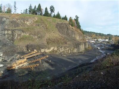
Miningfacilityoilgasmineralpreciousmetals
SECTION 29 TOWNSHIP 18 RANGE 2W QUARTER SW NE BLA037453TW TR A DOCUMENT 3593259
X
Thurston
53067C0164F
Washington
2024
9.10 AC
2024
Outlying Thurston County
011000
Olympia
864 SF
Olympia-Tumwater, WA
DEMOGRAPHICS near 2840 Black Lake Blvd Sw
1 Mile
3 Mile
5 Mile
2024 Total Population
821
39,682
86,708
2029 Population
859
41,966
91,610
Pop Growth 2024-2029
+ 4.63%
+ 5.76%
+ 5.65%
Average Age
46
40
41
2024 Total Households
334
17,073
37,023
HH Growth 2024-2029
+ 4.49%
+ 5.80%
+ 5.80%
Median Household Inc
$101,515
$65,842
$77,367
Avg Household Size
2.40
2.20
2.30
2024 Avg HH Vehicles
2.00
2.00
2.00
Median Home Value
$434,146
$401,086
$424,321
Median Year Built
1978
1990
1985
Nearby Places
Map Layers
Map Styles
 Street
 Aerial
- Restaurants
- Banks
- Shops
- Fitness
- Groceries
SALE & LEASE HISTORY
LISTING DATE
SALE/LEASE

Sep 21, 2022
For Lease
May 02, 2022
For Lease
Nearby Properties
Address
Land Use
TOTAL SIZE
Lot Size
Zoning
Address
Land Use
TOTAL SIZE
Lot Size
Zoning
830,626 SF
21.53 AC
CAP
Address
Land Use
TOTAL SIZE
Lot Size
Zoning
523,407 SF
86.49 AC
R-4-8
Address
Land Use
TOTAL SIZE
Lot Size
Zoning
288,270 SF
11.88 AC
CAP
Address
Land Use
TOTAL SIZE
Lot Size
Zoning
353,503 SF
36.94 AC
MFM
Address
Land Use
TOTAL SIZE
Lot Size
Zoning
184,887 SF
41 AC
SFM1
Address
Land Use
TOTAL SIZE
Lot Size
Zoning
602,509 SF
49.48 AC
HDC-4
Address
Land Use
TOTAL SIZE
Lot Size
Zoning
151,657 SF
2.62 AC
MS
Address
Land Use
TOTAL SIZE
Lot Size
Zoning
235,042 SF
17.16 AC
MFM
Address
Land Use
TOTAL SIZE
Lot Size
Zoning
175,178 SF
36.69 AC
R-4-8
Address
Land Use
TOTAL SIZE
Lot Size
Zoning
243,845 SF
12.58 AC
RM-24
Address
Land Use
TOTAL SIZE
Lot Size
Zoning
273,091 SF
17.87 AC
PO/RM
Address
Land Use
TOTAL SIZE
Lot Size
Zoning
217,366 SF
10.88 AC
RM-24
Address
Land Use
TOTAL SIZE
Lot Size
Zoning
102,698 SF
14.81 AC
LI
Address
Land Use
TOTAL SIZE
Lot Size
Zoning
147,418 SF
11.74 AC
MFH
Address
Land Use
TOTAL SIZE
Lot Size
Zoning
241,689 SF
10.75 AC
RM-24
Address
Land Use
TOTAL SIZE
Lot Size
Zoning
175,938 SF
13 AC
MFM
Address
Land Use
TOTAL SIZE
Lot Size
Zoning
161,002 SF
8.66 AC
PO/RM
Address
Land Use
TOTAL SIZE
Lot Size
Zoning
80,956 SF
20.97 AC
SFL
Address
Land Use
TOTAL SIZE
Lot Size
Zoning
140,850 SF
5.73 AC
MFH
Address
Land Use
TOTAL SIZE
Lot Size
Zoning
133,336 SF
5.88 AC
RM-24
Address
Land Use
TOTAL SIZE
Lot Size
Zoning
109,072 SF
2.57 AC
R-6-12
Address
Land Use
TOTAL SIZE
Lot Size
Zoning
112,020 SF
5.91 AC
MFH
Address
Land Use
TOTAL SIZE
Lot Size
Zoning
96,853 SF
20.40 AC
PUD
Address
Land Use
TOTAL SIZE
Lot Size
Zoning
178,997 SF
21.67 AC
HDC-4
Address
Land Use
TOTAL SIZE
Lot Size
Zoning
172,092 SF
8.88 AC
RM-24
Address
Land Use
TOTAL SIZE
Lot Size
Zoning
248,879 SF
11.16 AC
LI
Address
Land Use
TOTAL SIZE
Lot Size
Zoning
176,932 SF
9.39 AC
RM-18
Address
Land Use
TOTAL SIZE
Lot Size
Zoning
166,511 SF
8.93 AC
RM-24
Address
Land Use
TOTAL SIZE
Lot Size
Zoning
99,736 SF
6.76 AC
GC
Address
Land Use
TOTAL SIZE
Lot Size
Zoning
143,378 SF
15.95 AC
HDC-4
The World's #1 Commercial Real Estate Marketplace
Connect with us
© 2025 CoStar Group
The information above has been obtained from sources believed reliable. While we do not doubt its accuracy we have not verified it and make no guarantee, warranty or representation about it. It is your responsibility to independently confirm its accuracy and completeness. Any projections, opinions, assumptions, or estimates used are for example only and do not represent the current or future performance of the property. The value of this transaction to you depends on tax and other factors which should be evaluated by your tax, financial, and legal advisors. You and your advisors should conduct a careful, independent investigation of the property to determine to your satisfaction the suitability of the property for your needs.