Property Record
8328 Lemont Rd, Darien, IL 60561
NEARBY LISTINGS FOR SALE OR LEASE
Property Detail
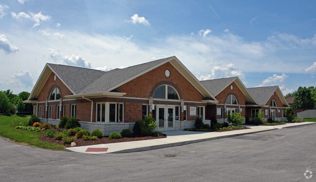
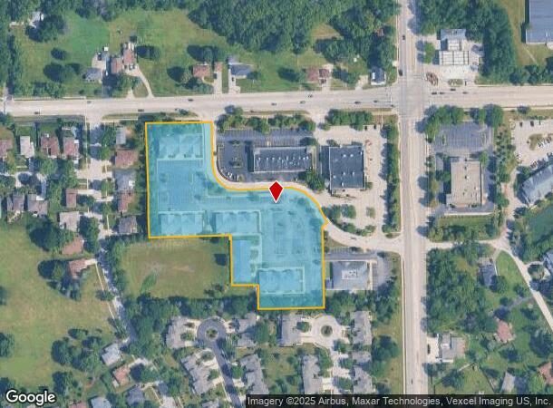
8328 Lemont Rd
Chicago-Naperville-Elgin, IL-IN-WI
Crossroads Of Darien Condos
09-31-415-007
CROSSROADS OF DARIEN CONDOS UNIT E4 12.23 PERCENT COM INT 8.27 PERCENT FOR 2007 12.23 PERCENT FOR 2008
Commercialnec
DuPage
X
Illinois
17043C0257J
3
2024
4.42 AC
2024
Western East/West Corr
845809
Chicago
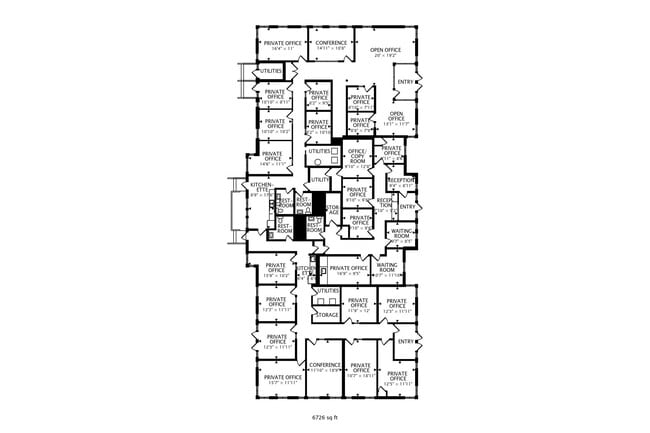
1,998 SF
DEMOGRAPHICS near 8328 Lemont Rd
1 Mile
3 Mile
5 Mile
2024 Total Population
7,295
87,284
220,777
2029 Population
7,163
86,195
218,161
Pop Growth 2024-2029
(1.81%)
(1.25%)
(1.18%)
Average Age
44
42
42
2024 Total Households
2,764
34,243
86,862
HH Growth 2024-2029
(1.95%)
(1.28%)
(1.24%)
Median Household Inc
$117,357
$91,108
$94,930
Avg Household Size
2.60
2.50
2.50
2024 Avg HH Vehicles
2.00
2.00
2.00
Median Home Value
$391,701
$331,863
$348,927
Median Year Built
1984
1977
1977
Nearby Places
Map Layers
Map Styles
 Street
 Aerial
- Restaurants
- Banks
- Shops
- Fitness
- Groceries
PUBLIC TRANSPORTATION
COMMUTER RAIL
Downers Grove Main Street Station (Burlington Northern-Santa Fe Railway Line - Northeast Illinois Regional Commuter Railroad (Metra))
DRIVE
WALK
Distance
Downers Grove Main Street Station (Burlington Northern-Santa Fe Railway Line - Northeast Illinois Regional Commuter Railroad (Metra))
9 min
4.5 mi
Downers Grove Fairview Avenue Station (Burlington Northern-Santa Fe Railway Line - Northeast Illinois Regional Commuter Railroad (Metra))
DRIVE
WALK
Distance
Downers Grove Fairview Avenue Station (Burlington Northern-Santa Fe Railway Line - Northeast Illinois Regional Commuter Railroad (Metra))
10 min
5.2 mi
AIRPORT
Chicago Midway International
DRIVE
WALK
Distance
Chicago Midway International
24 min
16.8 mi
Chicago O'Hare International
DRIVE
WALK
Distance
Chicago O'Hare International
40 min
25.8 mi
Freight Ports
Port Milwaukee
DRIVE
WALK
Distance
Port Milwaukee
121 min
97.6 mi
SALE & LEASE HISTORY
LISTING DATE
SALE/LEASE

Mar 21, 2023
For Sale
Nearby Properties
Address
Land Use
TOTAL SIZE
Lot Size
Zoning
Address
Land Use
TOTAL SIZE
Lot Size
Zoning
439,070 SF
38.77 AC
C
Address
Land Use
TOTAL SIZE
Lot Size
Zoning
22.17 AC
M
Address
Land Use
TOTAL SIZE
Lot Size
Zoning
21,520 SF
32.67 AC
Address
Land Use
TOTAL SIZE
Lot Size
Zoning
13.53 AC
M
Address
Land Use
TOTAL SIZE
Lot Size
Zoning
373,827 SF
21.30 AC
Address
Land Use
TOTAL SIZE
Lot Size
Zoning
21.12 AC
Address
Land Use
TOTAL SIZE
Lot Size
Zoning
18.23 AC
M
Address
Land Use
TOTAL SIZE
Lot Size
Zoning
315,708 SF
21.95 AC
M
Address
Land Use
TOTAL SIZE
Lot Size
Zoning
368,233 SF
16.12 AC
Address
Land Use
TOTAL SIZE
Lot Size
Zoning
19.02 AC
M
Address
Land Use
TOTAL SIZE
Lot Size
Zoning
388,561 SF
12.77 AC
Address
Land Use
TOTAL SIZE
Lot Size
Zoning
14.98 AC
M
Address
Land Use
TOTAL SIZE
Lot Size
Zoning
308,196 SF
17.65 AC
M
Address
Land Use
TOTAL SIZE
Lot Size
Zoning
334,656 SF
17.72 AC
I
Address
Land Use
TOTAL SIZE
Lot Size
Zoning
9.58 AC
M
Address
Land Use
TOTAL SIZE
Lot Size
Zoning
353,286 SF
19.84 AC
Address
Land Use
TOTAL SIZE
Lot Size
Zoning
28.89 AC
Address
Land Use
TOTAL SIZE
Lot Size
Zoning
173,098 SF
16.32 AC
R-6
Address
Land Use
TOTAL SIZE
Lot Size
Zoning
264,310 SF
12.21 AC
I
Address
Land Use
TOTAL SIZE
Lot Size
Zoning
173,459 SF
14.58 AC
C
Address
Land Use
TOTAL SIZE
Lot Size
Zoning
513,805 SF
23.84 AC
Address
Land Use
TOTAL SIZE
Lot Size
Zoning
126,165 SF
20.34 AC
Address
Land Use
TOTAL SIZE
Lot Size
Zoning
9.97 AC
M
Address
Land Use
TOTAL SIZE
Lot Size
Zoning
13.42 AC
Address
Land Use
TOTAL SIZE
Lot Size
Zoning
351,257 SF
16.39 AC
I
Address
Land Use
TOTAL SIZE
Lot Size
Zoning
396,546 SF
20.33 AC
I
Address
Land Use
TOTAL SIZE
Lot Size
Zoning
13.46 AC
M
Address
Land Use
TOTAL SIZE
Lot Size
Zoning
367,990 SF
17.32 AC
I
Address
Land Use
TOTAL SIZE
Lot Size
Zoning
268,566 SF
15.24 AC
M
Address
Land Use
TOTAL SIZE
Lot Size
Zoning
314,196 SF
21.08 AC
The World's #1 Commercial Real Estate Marketplace
Connect with us
© 2025 CoStar Group
The information above has been obtained from sources believed reliable. While we do not doubt its accuracy we have not verified it and make no guarantee, warranty or representation about it. It is your responsibility to independently confirm its accuracy and completeness. Any projections, opinions, assumptions, or estimates used are for example only and do not represent the current or future performance of the property. The value of this transaction to you depends on tax and other factors which should be evaluated by your tax, financial, and legal advisors. You and your advisors should conduct a careful, independent investigation of the property to determine to your satisfaction the suitability of the property for your needs.