Property Record
2841 Greenbriar Pkwy Sw, Atlanta, GA 30331

NEARBY LISTINGS FOR SALE OR LEASE
Property Detail
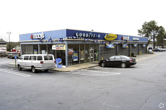
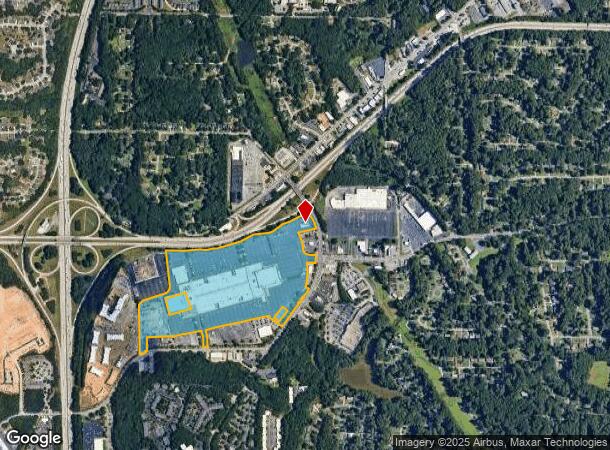
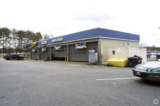
2841 Greenbriar Pkwy Sw
14-0229-LL-067-6
Greenbriar
Regionalshoppingcenterormallwithanchorstore
GREENBRIAR MALL F/C 11/24, SEVERAL STORES CLOSED CB26 TO CHECK FOR NEW TENTANTS AND OVERRIDE UPDATE PHOTOS
X
Fulton
13121C0353F
Georgia
2024
51.57 AC
2025
College Park/SW Atl
007705
Atlanta
764,659 SF
Atlanta-Sandy Springs-Roswell, GA
DEMOGRAPHICS near 2841 Greenbriar Pkwy Sw
1 Mile
3 Mile
5 Mile
2024 Total Population
7,936
72,036
169,442
2029 Population
8,138
74,372
175,904
Pop Growth 2024-2029
+ 2.55%
+ 3.24%
+ 3.81%
Average Age
43
39
39
2024 Total Households
3,682
30,641
70,489
HH Growth 2024-2029
+ 2.99%
+ 3.29%
+ 3.85%
Median Household Inc
$47,523
$51,230
$51,733
Avg Household Size
2.10
2.30
2.30
2024 Avg HH Vehicles
1.00
1.00
1.00
Median Home Value
$231,278
$242,582
$253,117
Median Year Built
1976
1972
1971
Nearby Places
Map Layers
Map Styles
 Street
 Aerial
- Restaurants
- Banks
- Shops
- Fitness
- Groceries
PUBLIC TRANSPORTATION
AIRPORT
Hartsfield - Jackson Atlanta International
DRIVE
WALK
Distance
Hartsfield - Jackson Atlanta International
18 min
8.9 mi
Freight Ports
Georgia Ports - Savannah
DRIVE
WALK
Distance
Georgia Ports - Savannah
281 min
249.8 mi
Nearby Properties
Address
Land Use
TOTAL SIZE
Lot Size
Zoning
Address
Land Use
TOTAL SIZE
Lot Size
Zoning
196,294 SF
0.49 AC
R1
Address
Land Use
TOTAL SIZE
Lot Size
Zoning
356,458 SF
18.72 AC
PDMU
Address
Land Use
TOTAL SIZE
Lot Size
Zoning
802,908 SF
18.26 AC
RG3
Address
Land Use
TOTAL SIZE
Lot Size
Zoning
4,455,803 SF
16.39 AC
C2
Address
Land Use
TOTAL SIZE
Lot Size
Zoning
6,069,632 SF
26.42 AC
R4
Address
Land Use
TOTAL SIZE
Lot Size
Zoning
330,838 SF
13.71 AC
PDMU
Address
Land Use
TOTAL SIZE
Lot Size
Zoning
5,459 SF
12.97 AC
C1
Address
Land Use
TOTAL SIZE
Lot Size
Zoning
3,411,710 SF
25.97 AC
RG3
Address
Land Use
TOTAL SIZE
Lot Size
Zoning
282,610 SF
11.20 AC
C1
Address
Land Use
TOTAL SIZE
Lot Size
Zoning
235,301 SF
27.20 AC
C2MC
Address
Land Use
TOTAL SIZE
Lot Size
Zoning
213,314 SF
16.48 AC
C2C
Address
Land Use
TOTAL SIZE
Lot Size
Zoning
2,057,484 SF
14.78 AC
R4
Address
Land Use
TOTAL SIZE
Lot Size
Zoning
274,442 SF
20.33 AC
RG2
Address
Land Use
TOTAL SIZE
Lot Size
Zoning
3,268,352 SF
23.31 AC
RG2
Address
Land Use
TOTAL SIZE
Lot Size
Zoning
135,211 SF
51.76 AC
OI
Address
Land Use
TOTAL SIZE
Lot Size
Zoning
563,256 SF
22.69 AC
I1
Address
Land Use
TOTAL SIZE
Lot Size
Zoning
634,503 SF
19.94 AC
R3
Address
Land Use
TOTAL SIZE
Lot Size
Zoning
3,289,702 SF
16.23 AC
C1C
Address
Land Use
TOTAL SIZE
Lot Size
Zoning
395,218 SF
21.61 AC
A1
Address
Land Use
TOTAL SIZE
Lot Size
Zoning
602,694 SF
9.32 AC
C1
Address
Land Use
TOTAL SIZE
Lot Size
Zoning
28.58 AC
Address
Land Use
TOTAL SIZE
Lot Size
Zoning
4.25 AC
R3
Address
Land Use
TOTAL SIZE
Lot Size
Zoning
6,834,480 SF
9.85 AC
RG3
Address
Land Use
TOTAL SIZE
Lot Size
Zoning
274,563 SF
65.24 AC
C2
Address
Land Use
TOTAL SIZE
Lot Size
Zoning
2,002,026 SF
17.51 AC
RLC
Address
Land Use
TOTAL SIZE
Lot Size
Zoning
2,963,779 SF
10.07 AC
C1
Address
Land Use
TOTAL SIZE
Lot Size
Zoning
612,164 SF
34.83 AC
Address
Land Use
TOTAL SIZE
Lot Size
Zoning
9,590,784 SF
27.23 AC
RG3
Address
Land Use
TOTAL SIZE
Lot Size
Zoning
5,238,150 SF
24.10 AC
R3C
The World's #1 Commercial Real Estate Marketplace
Connect with us
© 2025 CoStar Group
The information above has been obtained from sources believed reliable. While we do not doubt its accuracy we have not verified it and make no guarantee, warranty or representation about it. It is your responsibility to independently confirm its accuracy and completeness. Any projections, opinions, assumptions, or estimates used are for example only and do not represent the current or future performance of the property. The value of this transaction to you depends on tax and other factors which should be evaluated by your tax, financial, and legal advisors. You and your advisors should conduct a careful, independent investigation of the property to determine to your satisfaction the suitability of the property for your needs.