Property Record
2845 E Mary Ingles Hwy E, Augusta, KY 41002
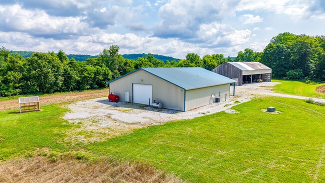

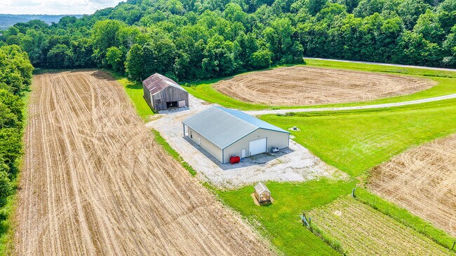
This Property Is For Sale
Property Detail
2845 E Mary Ingles Hwy E
Cincinnati, OH-KY-IN
BUILDING W/LIVING QUARTERS & 112 AC
57-05A
BRACKEN
Agriculturalland
Kentucky
AE The base floodplain where base flood elevations are provided. AE Zones are now used on new format FIRMs instead of A1-A30 Zones.
112 AC
2025
Bracken County
2025
Cincinnati/Dayton
950100
NEARBY LISTINGS FOR SALE OR LEASE
-
-
View all Augusta listings for sale on LoopNet.com
DEMOGRAPHICS near 2845 E Mary Ingles Hwy E
1 mile
3 mile
5 mile
2025 Total Population
116
1,885
3,798
2030 Population
116
1,900
3,825
Pop Growth 2025-2030
0.00%
+ 0.80%
+ 0.71%
Average Age
43
43
43
2025 Total Households
45
792
1,565
HH Growth 2025-2030
0.00%
+ 0.76%
+ 0.70%
Median Household Inc
$63,750
$55,312
$57,654
Avg Household Size
2.40
2.40
2.40
2025 Avg HH Vehicles
2.00
2.00
2.00
Median Home Value
$176,922
$159,782
$164,123
Median Year Built
1988
1953
1970
Nearby Places
Map Layers
Map Styles
 Street
 Aerial
Layers
 Traffic
 Biking
Places
Listings with unknown addresses are not visible on the map
- Restaurants
- Banks
- Shops
- Fitness
- Groceries
Nearby Properties
Address
Land Use
TOTAL SIZE
Lot Size
Zoning
Address
Land Use
TOTAL SIZE
Lot Size
Zoning
88,877 SF
1.30 AC
Address
Land Use
TOTAL SIZE
Lot Size
Zoning
310,000 SF
1.83 AC
Address
Land Use
TOTAL SIZE
Lot Size
Zoning
9.78 AC
Address
Land Use
TOTAL SIZE
Lot Size
Zoning
Address
Land Use
TOTAL SIZE
Lot Size
Zoning
7,780 SF
0.31 AC
Address
Land Use
TOTAL SIZE
Lot Size
Zoning
3,504 SF
44 AC
Address
Land Use
TOTAL SIZE
Lot Size
Zoning
Address
Land Use
TOTAL SIZE
Lot Size
Zoning
2,056 SF
47.20 AC
Address
Land Use
TOTAL SIZE
Lot Size
Zoning
2,400 SF
0.08 AC
Address
Land Use
TOTAL SIZE
Lot Size
Zoning
0.11 AC
Address
Land Use
TOTAL SIZE
Lot Size
Zoning
1,398 SF
214.51 AC
Address
Land Use
TOTAL SIZE
Lot Size
Zoning
3,360 SF
16.29 AC
Address
Land Use
TOTAL SIZE
Lot Size
Zoning
Address
Land Use
TOTAL SIZE
Lot Size
Zoning
1.21 AC
Address
Land Use
TOTAL SIZE
Lot Size
Zoning
6,154 SF
19.58 AC
Address
Land Use
TOTAL SIZE
Lot Size
Zoning
1,196 SF
0.64 AC
Address
Land Use
TOTAL SIZE
Lot Size
Zoning
21.47 AC
Address
Land Use
TOTAL SIZE
Lot Size
Zoning
2,848 SF
0.18 AC
Address
Land Use
TOTAL SIZE
Lot Size
Zoning
0.12 AC
Address
Land Use
TOTAL SIZE
Lot Size
Zoning
184.37 AC
Address
Land Use
TOTAL SIZE
Lot Size
Zoning
0.13 AC
Address
Land Use
TOTAL SIZE
Lot Size
Zoning
7,089 SF
0.31 AC
Address
Land Use
TOTAL SIZE
Lot Size
Zoning
188.10 AC
Address
Land Use
TOTAL SIZE
Lot Size
Zoning
Address
Land Use
TOTAL SIZE
Lot Size
Zoning
253.60 AC
Address
Land Use
TOTAL SIZE
Lot Size
Zoning
Address
Land Use
TOTAL SIZE
Lot Size
Zoning
5,040 SF
14.74 AC
Address
Land Use
TOTAL SIZE
Lot Size
Zoning
4,155 SF
0.66 AC
Address
Land Use
TOTAL SIZE
Lot Size
Zoning
15.51 AC
Address
Land Use
TOTAL SIZE
Lot Size
Zoning
93.76 AC
The World's #1 Commercial Real Estate Marketplace
Connect with us
© 2026 CoStar Group
The information above has been obtained from sources believed reliable. While we do not doubt its accuracy we have not verified it and make no guarantee, warranty or representation about it. It is your responsibility to independently confirm its accuracy and completeness. Any projections, opinions, assumptions, or estimates used are for example only and do not represent the current or future performance of the property. The value of this transaction to you depends on tax and other factors which should be evaluated by your tax, financial, and legal advisors. You and your advisors should conduct a careful, independent investigation of the property to determine to your satisfaction the suitability of the property for your needs.