No Photo
Property Record
2845 W State Road 66, Rockport, IN 47635

NEARBY LISTINGS FOR SALE OR LEASE
-
-
View all Rockport listings for sale on LoopNet.com
Property Detail
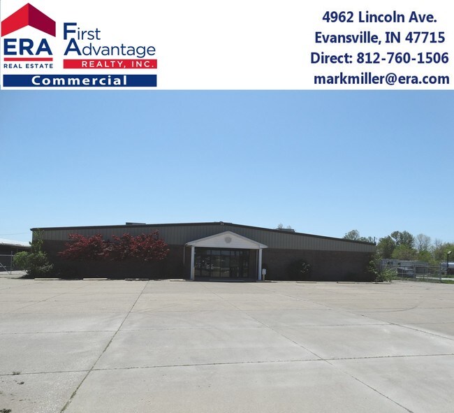
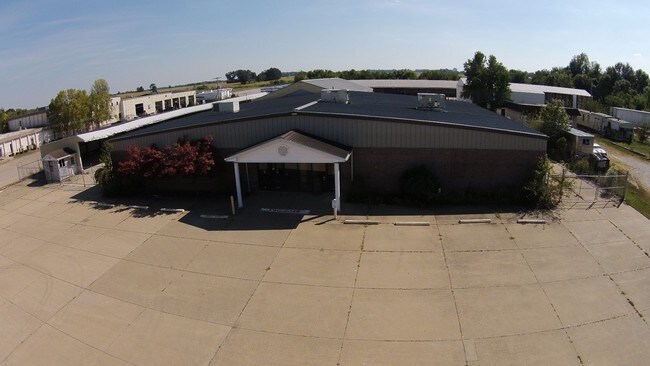
2845 W State Road 66
Storebuilding
PT NW NW 20-7-6. 8.29 A.
X
Spencer
18147C0240C
Indiana
2024
8.29 AC
2024
Other Market Areas
953000
74-15-20-200-006.000-017
10,212 SF
DEMOGRAPHICS near 2845 W State Road 66
1 Mile
3 Mile
5 Mile
2024 Total Population
664
2,106
6,017
2029 Population
674
2,154
6,184
Pop Growth 2024-2029
+ 1.51%
+ 2.28%
+ 2.78%
Average Age
43
42
43
2024 Total Households
272
878
2,512
HH Growth 2024-2029
+ 1.10%
+ 2.28%
+ 2.79%
Median Household Inc
$57,856
$55,660
$52,285
Avg Household Size
2.40
2.40
2.30
2024 Avg HH Vehicles
3.00
2.00
2.00
Median Home Value
$180,356
$167,665
$157,309
Median Year Built
1982
1976
1974
Nearby Places
Map Layers
Map Styles
 Street
 Aerial
- Restaurants
- Banks
- Shops
- Fitness
- Groceries
PUBLIC TRANSPORTATION
AIRPORT
Evansville Regional
DRIVE
WALK
Distance
Evansville Regional
48 min
30.6 mi
Freight Ports
Port of Toledo
DRIVE
WALK
Distance
Port of Toledo
463 min
402.1 mi
SALE & LEASE HISTORY
LISTING DATE
SALE/LEASE

Sep 23, 2016
For Sale
Nov 10, 2017
For Sale
Nearby Properties
Address
Land Use
TOTAL SIZE
Lot Size
Zoning
Address
Land Use
TOTAL SIZE
Lot Size
Zoning
11,288 SF
17.14 AC
B3
Address
Land Use
TOTAL SIZE
Lot Size
Zoning
2,621 SF
22.18 AC
B3
Address
Land Use
TOTAL SIZE
Lot Size
Zoning
9,100 SF
1.06 AC
B3
Address
Land Use
TOTAL SIZE
Lot Size
Zoning
10,160 SF
5 AC
B3
Address
Land Use
TOTAL SIZE
Lot Size
Zoning
12,876 SF
7.82 AC
BP3
Address
Land Use
TOTAL SIZE
Lot Size
Zoning
8,400 SF
1.03 AC
B3
Address
Land Use
TOTAL SIZE
Lot Size
Zoning
81.35 AC
I-2
Address
Land Use
TOTAL SIZE
Lot Size
Zoning
26,059 SF
4.29 AC
Address
Land Use
TOTAL SIZE
Lot Size
Zoning
3,540 SF
4.29 AC
I1
Address
Land Use
TOTAL SIZE
Lot Size
Zoning
6,650 SF
0.53 AC
B3
Address
Land Use
TOTAL SIZE
Lot Size
Zoning
14,925 SF
6.16 AC
I1
Address
Land Use
TOTAL SIZE
Lot Size
Zoning
5,200 SF
1.39 AC
I1
Address
Land Use
TOTAL SIZE
Lot Size
Zoning
6,574 SF
2.36 AC
R1
Address
Land Use
TOTAL SIZE
Lot Size
Zoning
3,190 SF
2.43 AC
B3
Address
Land Use
TOTAL SIZE
Lot Size
Zoning
5,823 SF
5.61 AC
R1
Address
Land Use
TOTAL SIZE
Lot Size
Zoning
19,632 SF
13.55 AC
B3
Address
Land Use
TOTAL SIZE
Lot Size
Zoning
4,040 SF
0.95 AC
I1
Address
Land Use
TOTAL SIZE
Lot Size
Zoning
156.23 AC
R1
Address
Land Use
TOTAL SIZE
Lot Size
Zoning
13,330 SF
1.48 AC
BP3
Address
Land Use
TOTAL SIZE
Lot Size
Zoning
175.48 AC
Address
Land Use
TOTAL SIZE
Lot Size
Zoning
7,600 SF
6.72 AC
BP3
Address
Land Use
TOTAL SIZE
Lot Size
Zoning
22.15 AC
B3
Address
Land Use
TOTAL SIZE
Lot Size
Zoning
3,680 SF
14.55 AC
R1
Address
Land Use
TOTAL SIZE
Lot Size
Zoning
159 AC
R1
Address
Land Use
TOTAL SIZE
Lot Size
Zoning
4,756 SF
3 AC
R1
Address
Land Use
TOTAL SIZE
Lot Size
Zoning
4,870 SF
0.55 AC
Address
Land Use
TOTAL SIZE
Lot Size
Zoning
151.60 AC
A
Address
Land Use
TOTAL SIZE
Lot Size
Zoning
4,000 SF
2.29 AC
B3
Address
Land Use
TOTAL SIZE
Lot Size
Zoning
159.28 AC
A
The World's #1 Commercial Real Estate Marketplace
Connect with us
© 2025 CoStar Group
The information above has been obtained from sources believed reliable. While we do not doubt its accuracy we have not verified it and make no guarantee, warranty or representation about it. It is your responsibility to independently confirm its accuracy and completeness. Any projections, opinions, assumptions, or estimates used are for example only and do not represent the current or future performance of the property. The value of this transaction to you depends on tax and other factors which should be evaluated by your tax, financial, and legal advisors. You and your advisors should conduct a careful, independent investigation of the property to determine to your satisfaction the suitability of the property for your needs.