Property Record
28450 S Tamiami Trl, Bonita Springs, FL 34134
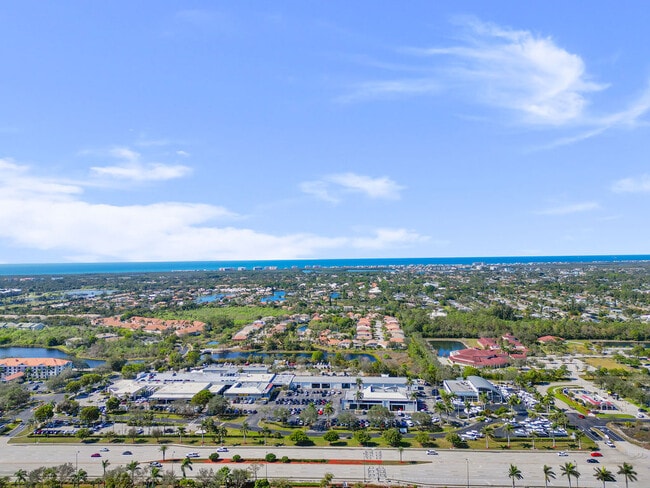
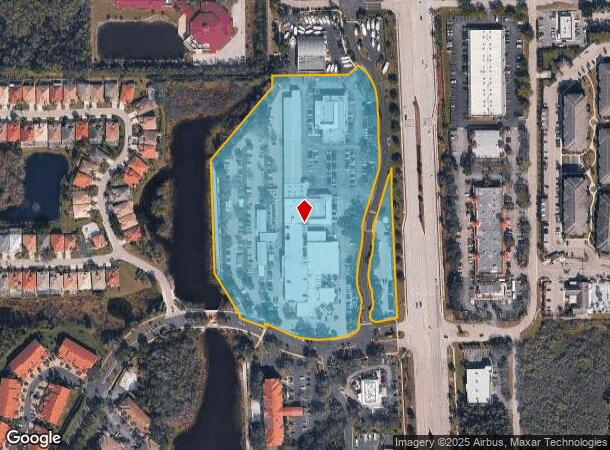
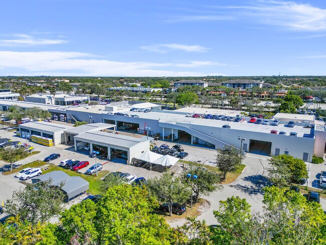
This Property Is For Sale
NEARBY LISTINGS FOR SALE OR LEASE
Property Detail
28450 S Tamiami Trl
Cape Coral-Fort Myers, FL
Woods Edge S/D
04-48-25-B3-0180B.0010
WOODS EDGE S/D PB49PGS53+54 PT TR B DESC OR2720/644 COM/LD + OR 2990/1182 + LOT 5 LESS 2012000054432
Vehiclerentalsvehiclesales
Lee
X
Florida
12021C0183J
5
2024
11.07 AC
2025
Bonita Springs
050601
Southwest Florida
125,641 SF
DEMOGRAPHICS near 28450 S Tamiami Trl
1 Mile
3 Mile
5 Mile
2024 Total Population
7,100
51,380
108,289
2029 Population
8,411
60,463
127,218
Pop Growth 2024-2029
+ 18.46%
+ 17.68%
+ 17.48%
Average Age
55
54
55
2024 Total Households
3,521
23,912
50,813
HH Growth 2024-2029
+ 18.03%
+ 17.34%
+ 17.29%
Median Household Inc
$72,640
$75,201
$83,680
Avg Household Size
1.90
2.10
2.00
2024 Avg HH Vehicles
2.00
2.00
2.00
Median Home Value
$407,991
$414,572
$450,870
Median Year Built
1995
1994
1995
Nearby Places
- Restaurants
- Banks
- Shops
- Fitness
- Groceries
PUBLIC TRANSPORTATION
AIRPORT
Southwest Florida International
DRIVE
WALK
Distance
Southwest Florida International
32 min
22.9 mi
Freight Ports
Port Manatee
DRIVE
WALK
Distance
Port Manatee
141 min
122.6 mi
Nearby Properties
Address
Land Use
TOTAL SIZE
Lot Size
Zoning
Address
Land Use
TOTAL SIZE
Lot Size
Zoning
993,493 SF
86.10 AC
PUD
Address
Land Use
TOTAL SIZE
Lot Size
Zoning
313,544 SF
60 AC
A
Address
Land Use
TOTAL SIZE
Lot Size
Zoning
406,601 SF
19.88 AC
RPD
Address
Land Use
TOTAL SIZE
Lot Size
Zoning
311,416 SF
17.06 AC
Address
Land Use
TOTAL SIZE
Lot Size
Zoning
331,056 SF
8 AC
CPD
Address
Land Use
TOTAL SIZE
Lot Size
Zoning
252,506 SF
36.27 AC
PUD
Address
Land Use
TOTAL SIZE
Lot Size
Zoning
435,724 SF
64.61 AC
PUD
Address
Land Use
TOTAL SIZE
Lot Size
Zoning
227,264 SF
8.72 AC
A
Address
Land Use
TOTAL SIZE
Lot Size
Zoning
181,774 SF
6.19 AC
PUD
Address
Land Use
TOTAL SIZE
Lot Size
Zoning
366,884 SF
30.65 AC
RM-2
Address
Land Use
TOTAL SIZE
Lot Size
Zoning
253,108 SF
32.47 AC
PUD
Address
Land Use
TOTAL SIZE
Lot Size
Zoning
230,920 SF
7.80 AC
C-4
Address
Land Use
TOTAL SIZE
Lot Size
Zoning
286,416 SF
28.78 AC
CG
Address
Land Use
TOTAL SIZE
Lot Size
Zoning
214,836 SF
24.50 AC
CPD
Address
Land Use
TOTAL SIZE
Lot Size
Zoning
112,623 SF
13.10 AC
PUD
Address
Land Use
TOTAL SIZE
Lot Size
Zoning
464,234 SF
22.53 AC
CPD
Address
Land Use
TOTAL SIZE
Lot Size
Zoning
106,929 SF
23.05 AC
A
Address
Land Use
TOTAL SIZE
Lot Size
Zoning
57,867 SF
60.86 AC
PUD
Address
Land Use
TOTAL SIZE
Lot Size
Zoning
182,802 SF
18.08 AC
CC
Address
Land Use
TOTAL SIZE
Lot Size
Zoning
63,235 SF
22.36 AC
PUD
Address
Land Use
TOTAL SIZE
Lot Size
Zoning
133,571 SF
18.86 AC
C-4
Address
Land Use
TOTAL SIZE
Lot Size
Zoning
144,993 SF
8.73 AC
PUD
Address
Land Use
TOTAL SIZE
Lot Size
Zoning
4,772 SF
3.31 AC
CF-3
Address
Land Use
TOTAL SIZE
Lot Size
Zoning
Address
Land Use
TOTAL SIZE
Lot Size
Zoning
63,768 SF
8.73 AC
Address
Land Use
TOTAL SIZE
Lot Size
Zoning
52,150 SF
136.13 AC
PUD
Address
Land Use
TOTAL SIZE
Lot Size
Zoning
1.50 AC
RPD
Address
Land Use
TOTAL SIZE
Lot Size
Zoning
96,875 SF
5.52 AC
I
Address
Land Use
TOTAL SIZE
Lot Size
Zoning
111,478 SF
15.76 AC
AG-2
Address
Land Use
TOTAL SIZE
Lot Size
Zoning
117,766 SF
4.48 AC
RPD
The World's #1 Commercial Real Estate Marketplace
Connect with us
© 2025 CoStar Group
The information above has been obtained from sources believed reliable. While we do not doubt its accuracy we have not verified it and make no guarantee, warranty or representation about it. It is your responsibility to independently confirm its accuracy and completeness. Any projections, opinions, assumptions, or estimates used are for example only and do not represent the current or future performance of the property. The value of this transaction to you depends on tax and other factors which should be evaluated by your tax, financial, and legal advisors. You and your advisors should conduct a careful, independent investigation of the property to determine to your satisfaction the suitability of the property for your needs.