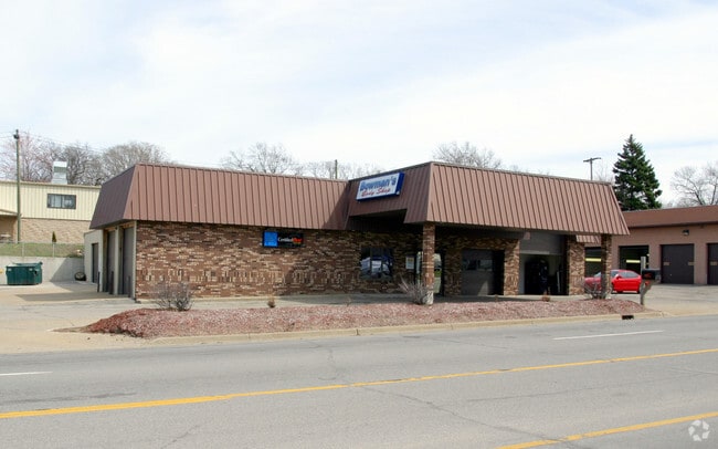
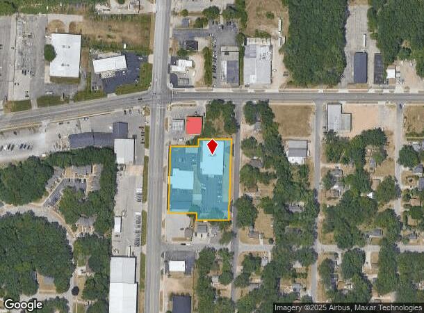
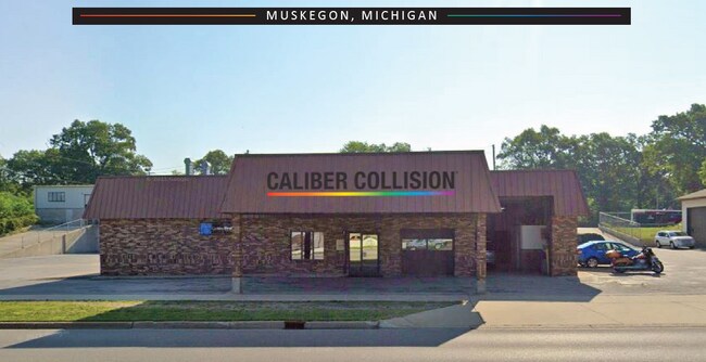
Property Record
2846 S Getty St, Norton Shores, MI 49444

NEARBY LISTINGS FOR SALE OR LEASE
Property Detail
2846 S Getty St
Muskegon, MI
Park View Terrace
27-700-001-0028-00
CITY OF NORTON SHORES PARK VIEW TERRACE LOTS 10 THRU 20 ALSO E 1/2 VAC ALLEY ADJ TO SD LOTS ALSO LOTS 28 THRU 36 ALSO W
Commercialnec
Muskegon
X
Michigan
26121C0278E
10-20
2024
1.77 AC
2025
Muskegon Heights
002601
West Michigan
20,199 SF
DEMOGRAPHICS near 2846 S Getty St
1 Mile
3 Mile
5 Mile
2024 Total Population
9,270
63,935
103,758
2029 Population
9,481
64,620
104,537
Pop Growth 2024-2029
+ 2.28%
+ 1.07%
+ 0.75%
Average Age
38
39
40
2024 Total Households
3,020
24,468
40,995
HH Growth 2024-2029
+ 2.68%
+ 1.06%
+ 0.73%
Median Household Inc
$32,426
$42,300
$49,731
Avg Household Size
2.40
2.30
2.30
2024 Avg HH Vehicles
1.00
1.00
2.00
Median Home Value
$69,509
$108,711
$140,006
Median Year Built
1959
1955
1961
Nearby Places
Map Layers
Map Styles
 Street
 Aerial
- Restaurants
- Banks
- Shops
- Fitness
- Groceries
SALE & LEASE HISTORY
LISTING DATE
SALE/LEASE

Apr 06, 2022
For Sale
Nearby Properties
Address
Land Use
TOTAL SIZE
Lot Size
Zoning
Address
Land Use
TOTAL SIZE
Lot Size
Zoning
490,693 SF
22.70 AC
Address
Land Use
TOTAL SIZE
Lot Size
Zoning
82,643 SF
5.20 AC
MC
Address
Land Use
TOTAL SIZE
Lot Size
Zoning
350,077 SF
41.42 AC
PUD
Address
Land Use
TOTAL SIZE
Lot Size
Zoning
129,264 SF
R
Address
Land Use
TOTAL SIZE
Lot Size
Zoning
84,452 SF
6.82 AC
PUD
Address
Land Use
TOTAL SIZE
Lot Size
Zoning
249,032 SF
19.18 AC
MFR
Address
Land Use
TOTAL SIZE
Lot Size
Zoning
223,802 SF
22.02 AC
SC-1
Address
Land Use
TOTAL SIZE
Lot Size
Zoning
79,321 SF
4.28 AC
B-3
Address
Land Use
TOTAL SIZE
Lot Size
Zoning
184,130 SF
3.16 AC
FBC-MS
Address
Land Use
TOTAL SIZE
Lot Size
Zoning
41,382 SF
6.20 AC
PUD
Address
Land Use
TOTAL SIZE
Lot Size
Zoning
271,435 SF
13.80 AC
I-2
Address
Land Use
TOTAL SIZE
Lot Size
Zoning
116,657 SF
1.60 AC
FBC-UR
Address
Land Use
TOTAL SIZE
Lot Size
Zoning
219,341 SF
18.55 AC
C-SE
Address
Land Use
TOTAL SIZE
Lot Size
Zoning
79,321 SF
5 AC
FBC-MS
Address
Land Use
TOTAL SIZE
Lot Size
Zoning
80,572 SF
12.98 AC
I-1
Address
Land Use
TOTAL SIZE
Lot Size
Zoning
194,708 SF
15.59 AC
C-2
Address
Land Use
TOTAL SIZE
Lot Size
Zoning
142,000 SF
1.60 AC
FBC-DT
Address
Land Use
TOTAL SIZE
Lot Size
Zoning
19,171 SF
6.55 AC
MC
Address
Land Use
TOTAL SIZE
Lot Size
Zoning
71,329 SF
I-2
Address
Land Use
TOTAL SIZE
Lot Size
Zoning
2,044 SF
4.10 AC
RT
Address
Land Use
TOTAL SIZE
Lot Size
Zoning
184,786 SF
24.10 AC
SUD
Address
Land Use
TOTAL SIZE
Lot Size
Zoning
125,059 SF
10.47 AC
PUD
Address
Land Use
TOTAL SIZE
Lot Size
Zoning
82,895 SF
13.09 AC
SC-1
Address
Land Use
TOTAL SIZE
Lot Size
Zoning
85,577 SF
8.72 AC
PUD
Address
Land Use
TOTAL SIZE
Lot Size
Zoning
33,750 SF
R
Address
Land Use
TOTAL SIZE
Lot Size
Zoning
241,589 SF
14.60 AC
I-2
Address
Land Use
TOTAL SIZE
Lot Size
Zoning
180,144 SF
3.29 AC
RM-1
Address
Land Use
TOTAL SIZE
Lot Size
Zoning
68,782 SF
10.52 AC
C-2
Address
Land Use
TOTAL SIZE
Lot Size
Zoning
121,466 SF
11.65 AC
SC-1
Address
Land Use
TOTAL SIZE
Lot Size
Zoning
143,193 SF
13.82 AC
SC-1
The World's #1 Commercial Real Estate Marketplace
Connect with us
© 2025 CoStar Group
The information above has been obtained from sources believed reliable. While we do not doubt its accuracy we have not verified it and make no guarantee, warranty or representation about it. It is your responsibility to independently confirm its accuracy and completeness. Any projections, opinions, assumptions, or estimates used are for example only and do not represent the current or future performance of the property. The value of this transaction to you depends on tax and other factors which should be evaluated by your tax, financial, and legal advisors. You and your advisors should conduct a careful, independent investigation of the property to determine to your satisfaction the suitability of the property for your needs.