Property Record
28475 Owens Branch Rd, Salisbury, MD 21801
NEARBY LISTINGS FOR SALE OR LEASE
Property Detail
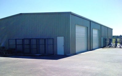
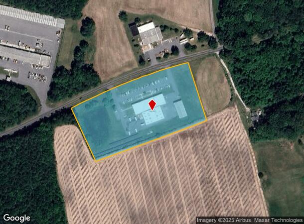
28475 Owens Branch Rd
09-072578
Property Survey For Wicomico Count Maryl
Manufacturinglight
6.311AC PAR A & C 28475 OWENS BRANCH RD SE OF HEBRON
X
Wicomico
24045C0095E
Maryland
2025
a c
2025
6.31 AC
010300
Other Market Areas
22,600 SF
Salisbury, MD-DE
DEMOGRAPHICS near 28475 Owens Branch Rd
1 Mile
3 Mile
5 Mile
2024 Total Population
3,147
36,264
75,820
2029 Population
3,188
36,785
77,298
Pop Growth 2024-2029
+ 1.30%
+ 1.44%
+ 1.95%
Average Age
38
37
38
2024 Total Households
1,220
13,202
29,101
HH Growth 2024-2029
+ 1.31%
+ 1.48%
+ 2.03%
Median Household Inc
$42,666
$54,177
$60,133
Avg Household Size
2.40
2.50
2.40
2024 Avg HH Vehicles
1.00
2.00
2.00
Median Home Value
$124,193
$218,363
$216,212
Median Year Built
1982
1973
1982
Nearby Places
Map Layers
Map Styles
 Street
 Aerial
- Restaurants
- Banks
- Shops
- Fitness
- Groceries
PUBLIC TRANSPORTATION
AIRPORT
Salisbury-Ocean City Wicomico Regional
DRIVE
WALK
Distance
Salisbury-Ocean City Wicomico Regional
19 min
9.3 mi
Nearby Properties
Address
Land Use
TOTAL SIZE
Lot Size
Zoning
Address
Land Use
TOTAL SIZE
Lot Size
Zoning
1,792 SF
76.32 AC
R20
Address
Land Use
TOTAL SIZE
Lot Size
Zoning
602,336 SF
22.69 AC
H
Address
Land Use
TOTAL SIZE
Lot Size
Zoning
25,000 SF
23.46 AC
I-2
Address
Land Use
TOTAL SIZE
Lot Size
Zoning
118,330 SF
1.99 AC
CBD
Address
Land Use
TOTAL SIZE
Lot Size
Zoning
103,992 SF
0.59 AC
CBD
Address
Land Use
TOTAL SIZE
Lot Size
Zoning
105,626 SF
53.26 AC
R-8
Address
Land Use
TOTAL SIZE
Lot Size
Zoning
6,136 SF
52.49 AC
R-10
Address
Land Use
TOTAL SIZE
Lot Size
Zoning
40,690 SF
9.02 AC
PDD
Address
Land Use
TOTAL SIZE
Lot Size
Zoning
3,408 SF
69.67 AC
I
Address
Land Use
TOTAL SIZE
Lot Size
Zoning
76,999 SF
7.72 AC
R-8
Address
Land Use
TOTAL SIZE
Lot Size
Zoning
60,949 SF
14.13 AC
R-8
Address
Land Use
TOTAL SIZE
Lot Size
Zoning
58,528 SF
15.05 AC
R8
Address
Land Use
TOTAL SIZE
Lot Size
Zoning
1,034 SF
18.79 AC
R-8A
Address
Land Use
TOTAL SIZE
Lot Size
Zoning
41,473 SF
1.20 AC
CBD
Address
Land Use
TOTAL SIZE
Lot Size
Zoning
195,541 SF
51.98 AC
Address
Land Use
TOTAL SIZE
Lot Size
Zoning
43,164 SF
1.83 AC
CBD
Address
Land Use
TOTAL SIZE
Lot Size
Zoning
37,198 SF
6.15 AC
LI
Address
Land Use
TOTAL SIZE
Lot Size
Zoning
15,260 SF
13.52 AC
R5A
Address
Land Use
TOTAL SIZE
Lot Size
Zoning
38,485 SF
24.09 AC
R-20
Address
Land Use
TOTAL SIZE
Lot Size
Zoning
1,804 SF
99.10 AC
R-20
Address
Land Use
TOTAL SIZE
Lot Size
Zoning
48,270 SF
2.30 AC
GC
Address
Land Use
TOTAL SIZE
Lot Size
Zoning
53,979 SF
4.92 AC
GC
Address
Land Use
TOTAL SIZE
Lot Size
Zoning
37,645 SF
16.43 AC
IP
Address
Land Use
TOTAL SIZE
Lot Size
Zoning
49,068 SF
2.92 AC
PRD
Address
Land Use
TOTAL SIZE
Lot Size
Zoning
135,750 SF
13.75 AC
R8
Address
Land Use
TOTAL SIZE
Lot Size
Zoning
36,177 SF
1.58 AC
GC
Address
Land Use
TOTAL SIZE
Lot Size
Zoning
20,970 SF
3.52 AC
Address
Land Use
TOTAL SIZE
Lot Size
Zoning
74,641 SF
7.10 AC
GC
Address
Land Use
TOTAL SIZE
Lot Size
Zoning
34,200 SF
15.95 AC
R-5A
Address
Land Use
TOTAL SIZE
Lot Size
Zoning
171,072 SF
15.19 AC
R-8A
The World's #1 Commercial Real Estate Marketplace
Connect with us
© 2026 CoStar Group
The information above has been obtained from sources believed reliable. While we do not doubt its accuracy we have not verified it and make no guarantee, warranty or representation about it. It is your responsibility to independently confirm its accuracy and completeness. Any projections, opinions, assumptions, or estimates used are for example only and do not represent the current or future performance of the property. The value of this transaction to you depends on tax and other factors which should be evaluated by your tax, financial, and legal advisors. You and your advisors should conduct a careful, independent investigation of the property to determine to your satisfaction the suitability of the property for your needs.