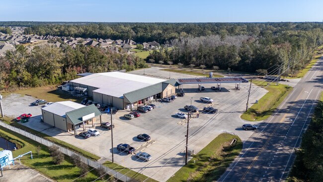
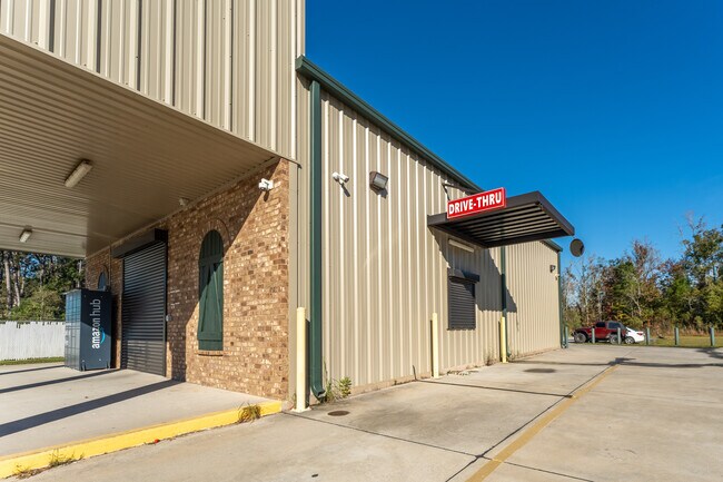
Property Record
28477 Highway 22, Ponchatoula, LA 70454

NEARBY LISTINGS FOR SALE OR LEASE
-
-
View all Ponchatoula listings for lease on LoopNet.com
Property Detail
28477 Highway 22
06416691
3.85A BEING TRACT Y-1 OF MADISONVILLE INVESTMENTS MINOR PARTITION OF TRACT Y VILLAGES AT BOCAGE PH I IN SEC 13 T7SR9E B1400 P
Commercialnec
Tangipahoa
A
Louisiana
22105C0500F
3.85 AC
2024
Louisiana South Area
2024
Other Market Areas
954602
Hammond, LA
17,158 SF
DEMOGRAPHICS near 28477 Highway 22
1 Mile
3 Mile
5 Mile
2024 Total Population
3,506
14,562
25,844
2029 Population
3,860
15,857
28,162
Pop Growth 2024-2029
+ 10.10%
+ 8.89%
+ 8.97%
Average Age
35
35
36
2024 Total Households
1,218
4,975
8,963
HH Growth 2024-2029
+ 10.18%
+ 9.03%
+ 9.06%
Median Household Inc
$82,477
$104,266
$102,741
Avg Household Size
2.80
2.90
2.80
2024 Avg HH Vehicles
2.00
2.00
2.00
Median Home Value
$247,065
$272,838
$276,015
Median Year Built
2010
2010
2008
Nearby Places
Map Layers
Map Styles
 Street
 Aerial
- Restaurants
- Banks
- Shops
- Fitness
- Groceries
SALE & LEASE HISTORY
LISTING DATE
SALE/LEASE

Dec 11, 2024
For Lease
Nearby Properties
Address
Land Use
TOTAL SIZE
Lot Size
Zoning
Address
Land Use
TOTAL SIZE
Lot Size
Zoning
114,192 SF
12.62 AC
Address
Land Use
TOTAL SIZE
Lot Size
Zoning
56,928 SF
12.20 AC
Address
Land Use
TOTAL SIZE
Lot Size
Zoning
34,200 SF
3.02 AC
Address
Land Use
TOTAL SIZE
Lot Size
Zoning
9,999 SF
1.14 AC
Address
Land Use
TOTAL SIZE
Lot Size
Zoning
9,083 SF
10.30 AC
Address
Land Use
TOTAL SIZE
Lot Size
Zoning
5,949 SF
2.30 AC
Address
Land Use
TOTAL SIZE
Lot Size
Zoning
13,645 SF
2.49 AC
Address
Land Use
TOTAL SIZE
Lot Size
Zoning
6,501 SF
1.07 AC
Address
Land Use
TOTAL SIZE
Lot Size
Zoning
4,438 SF
4.48 AC
Address
Land Use
TOTAL SIZE
Lot Size
Zoning
6,978 SF
1.51 AC
Address
Land Use
TOTAL SIZE
Lot Size
Zoning
3,969 SF
0.59 AC
Address
Land Use
TOTAL SIZE
Lot Size
Zoning
3,849 SF
Address
Land Use
TOTAL SIZE
Lot Size
Zoning
4,222 SF
4.99 AC
Address
Land Use
TOTAL SIZE
Lot Size
Zoning
8,995 SF
1.21 AC
Address
Land Use
TOTAL SIZE
Lot Size
Zoning
3,120 SF
0.61 AC
Address
Land Use
TOTAL SIZE
Lot Size
Zoning
3,849 SF
Address
Land Use
TOTAL SIZE
Lot Size
Zoning
3,087 SF
0.68 AC
Address
Land Use
TOTAL SIZE
Lot Size
Zoning
9,100 SF
3.26 AC
Address
Land Use
TOTAL SIZE
Lot Size
Zoning
9,100 SF
0.72 AC
Address
Land Use
TOTAL SIZE
Lot Size
Zoning
7,610 SF
4 AC
Address
Land Use
TOTAL SIZE
Lot Size
Zoning
3,204 SF
0.60 AC
Address
Land Use
TOTAL SIZE
Lot Size
Zoning
3,246 SF
Address
Land Use
TOTAL SIZE
Lot Size
Zoning
2,744 SF
Address
Land Use
TOTAL SIZE
Lot Size
Zoning
Address
Land Use
TOTAL SIZE
Lot Size
Zoning
2,982 SF
Address
Land Use
TOTAL SIZE
Lot Size
Zoning
2,676 SF
Address
Land Use
TOTAL SIZE
Lot Size
Zoning
3,095 SF
0.39 AC
Address
Land Use
TOTAL SIZE
Lot Size
Zoning
3,009 SF
0.41 AC
Address
Land Use
TOTAL SIZE
Lot Size
Zoning
2,938 SF
0.31 AC
The World's #1 Commercial Real Estate Marketplace
Connect with us
© 2026 CoStar Group
The information above has been obtained from sources believed reliable. While we do not doubt its accuracy we have not verified it and make no guarantee, warranty or representation about it. It is your responsibility to independently confirm its accuracy and completeness. Any projections, opinions, assumptions, or estimates used are for example only and do not represent the current or future performance of the property. The value of this transaction to you depends on tax and other factors which should be evaluated by your tax, financial, and legal advisors. You and your advisors should conduct a careful, independent investigation of the property to determine to your satisfaction the suitability of the property for your needs.